Why is Florence Stalling and moving South?
The recent development of Florence stalling at landfall versus inland is a pretty big change in terms of the overall impact to the insurance industry and, frankly, I think the NHC best summed it up in their 5:00 p.m. forecast discussion Number 50 yesterday.
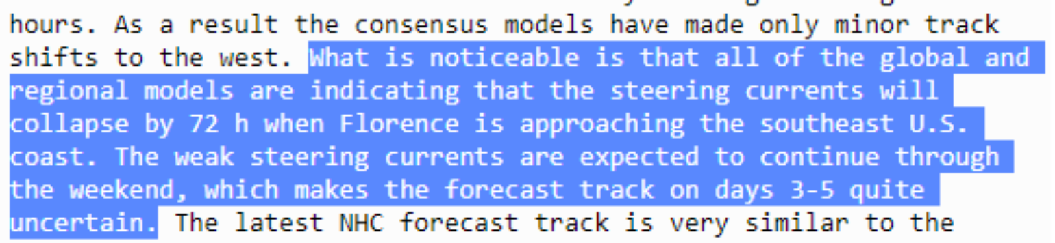
The steering currents have collapsed and could exacerbate any and all effects along hundreds of miles of coastline. This is not something the insurance industry wants to hear. It seems counterintuitive, and it is an unusual scenario. Florence will have nowhere else to go but south or along the coastline into South Carolina this weekend.
The best technical description might be from Doug Simonian, a meteorologist at www.nymetroweather.com.
A quick analysis of the 12z Euro today vs the 12z Euro yesterday, both valid 06z Friday. The NW Atlantic shortwave that @antmasiello has mentioned provides N to S flow, which cancels out the S to N flow along the periphery of the W Atlantic ridge, causing #Florence to stall. pic.twitter.com/nhLWkzST1w
— Doug Simonian (@snowmonian) September 11, 2018
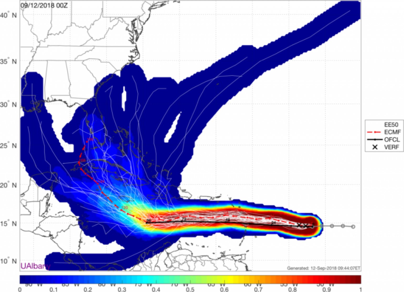
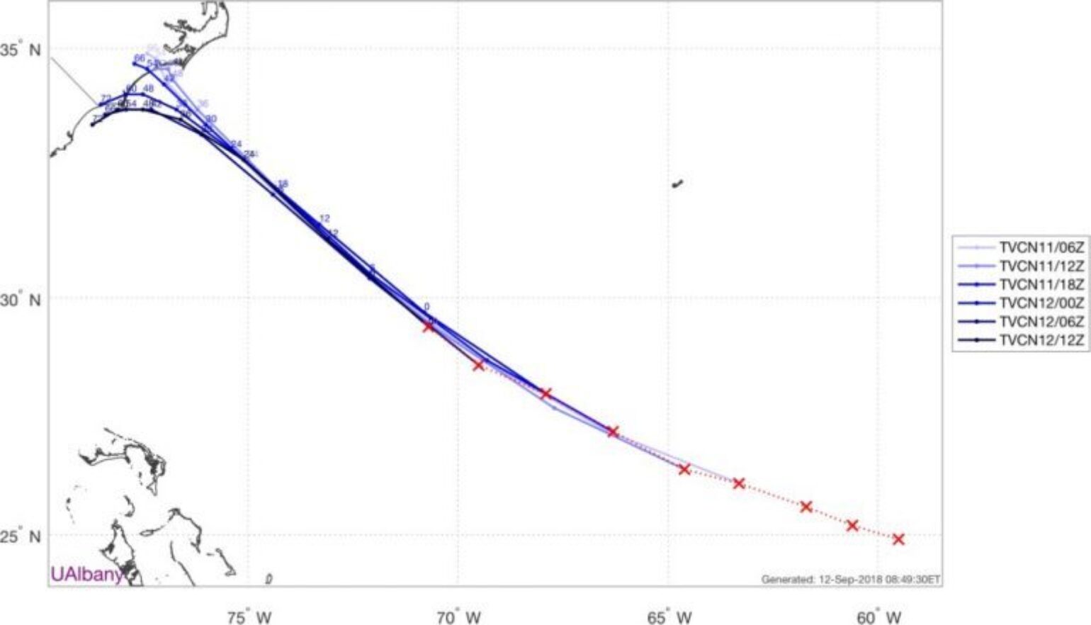
So, what does this all mean? The 500mb layer, which is roughly 18,000 feet in altitude and known as our midlayer, is often used to look for steering currents that drive hurricane direction. This has bridged the steering currents to the north, which means Florence has nowhere to go but stall or move southwest. In the short term, it still seems like it is certain that Florence will touch the North Carolina coast near Cape Fear, NC and then drop south. After 72 hours, however, it’s anyone’s guess as to what direction Florence will go, which is why the NHC cone of uncertainty continues to balloon along the coastline.
The Good: Based on this forecasted track change, the overall inland impact from heavy rains and tropical storm-force winds has diminished greatly for North Carolina. Another potential outcome is that as the storm slows towards the coastline it will create upwelling, causing the storm to weaken and, therefore, unlikely to stay a major hurricane any time after Friday morning when it is near the North Carolina coastline. However, if Florence can stay over water, it will maintain its hurricane structure and could still be at Category 1 or 2 hurricane strength for another day or so. If it moves inland, expect Florence to quickly be downgraded to a tropical storm. Finally, another positive note of a slower moving storm towards landfall or along the coastline is that it would likely draw in dry continental air, thus weakening the storm as it stalls. There are still signs that stronger wind shear will also help weaken the storm as it nears the coastline.
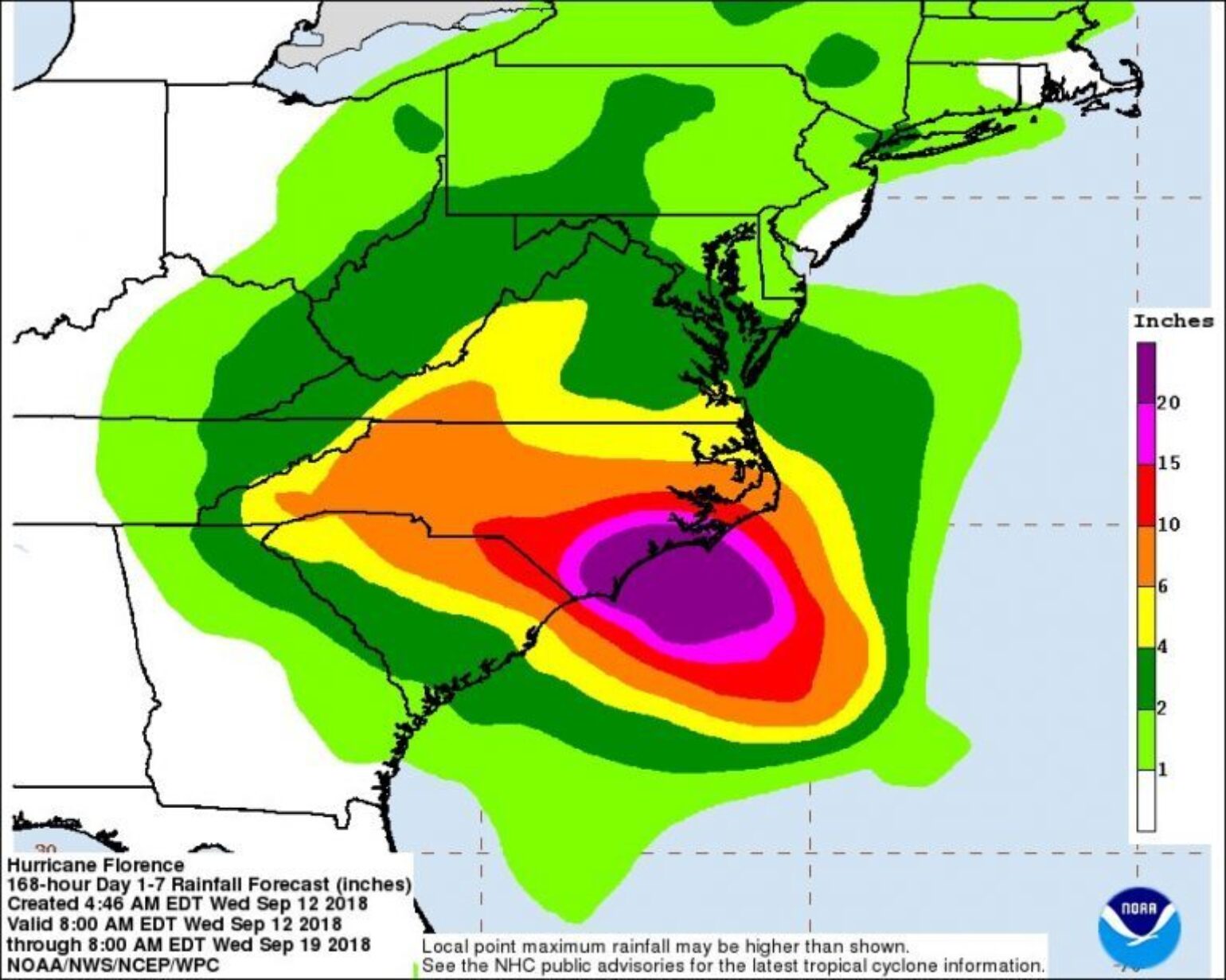
The Bad: The overall winds will still be strong right along the coastline near southern North Carolina and, if the storm tracks along the coastline, it would just put that much more property exposure at risk to hurricane-force winds. The fact that hour upon hours of hurricane force winds could occur can be just as destructive as a short period of higher wind speeds. This also shifts the heaviest rain and flooding along the entire coastline, and major flooding is still expected along the coastal inland areas, with heavier rains now forecasted over South Carolina and maybe even into Georgia.
Population Changes Along The CoastlineThe insurance industry is well aware of the exponential growth that has occurred along the coastal areas of the U.S. The graphic below illustrates the population growth between Myrtle Beach, SC and Wilmington, NC in 1940, 1990 and 2018. This rapid increase in the coastal population will increase potential insured losses from both wind and storm surge if Florence decides to track along the South Carolina coastline this weekend versus moving inland as a weaker tropical storm. It should be noted that a large portion of the population in this region has not experienced a hurricane of this magnitude since Hugo in 1989, and very few likely lived in the area during Hazel in 1954, the most recent Category 4 hurricane to impact the region. Thankfully, these analogs are no longer relevant to Florence’s forecast.
Storm Surge
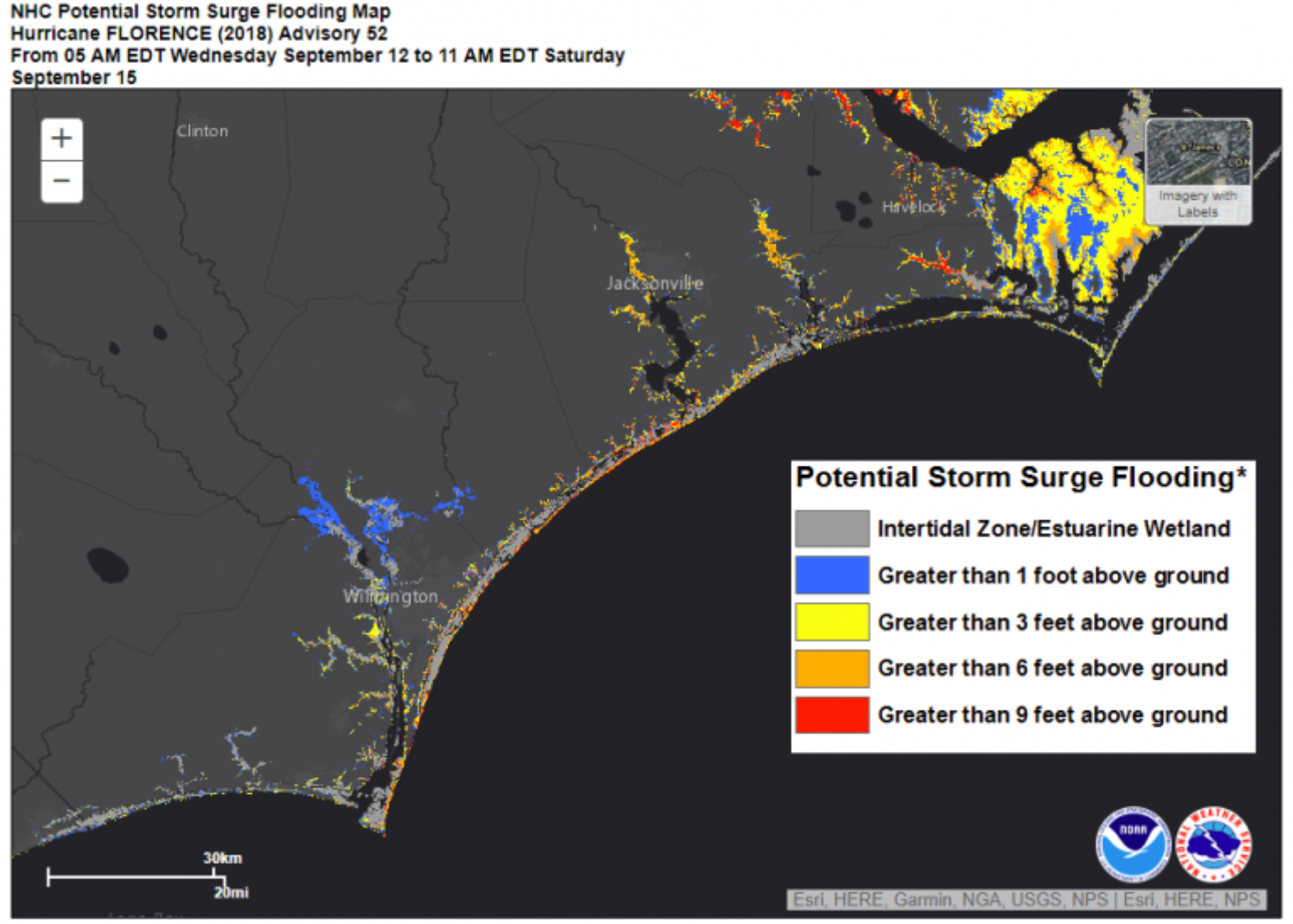
There are known impacts of storm surge which are well modeled in the NHC Potential Storm Surge Flooding Maps, the best resource at this time. There is really no good news in this scenario, and the scenarios only get worse. Initially, the storm surge scenario still plays out with the concave shape of the North Carolina coast being a significant contributor to storm surge, which allows water to pool while being directed inland. Therefore, at this time, the worst of the storm surge will likely occur along the southern South Carolina coastline. If Florence stays along the coast, it means hours of onshore winds over multiple tide cycles creating even bigger problems, and if the storm moves down along the South Carolina coast, it will see some even higher water heights. But, the storm surge impacts are highly dependent on the final track.
To better understand the impacts upwelling might have on Florence’s intensity as it stalls near the coastline, data from Air Launched Autonomous Micro Observer (ALAMO) can be used. These floats are launched out ahead of the storm by hurricane hunters to get observation of the thermal energy in the ocean, which is a prime driver for hurricane strength. As the hurricane passes, the data is collected in real time. Last night, Florence went right over ALAMO floater #9136, which showed substantial vertical mixing of the water column with the water going from 29 degree c to 27.5 degree c. It is this same vertical mixing that will likely weaken Florence along the coastline.
Tornado Risk
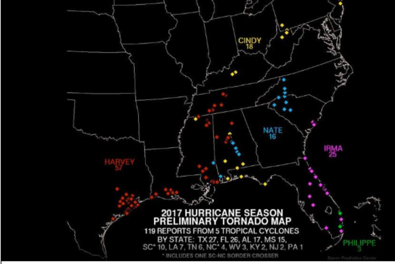
There has been very little discussion around the tornado risk from a landfalling hurricane. Currently, the Storm Prediction Center is not indicating any increase in tornado potential. Just last year, five named storms were responsible for 119 reported tornadoes across the U.S. Hurricane Harvey had the largest number of tornado reports with 57, mostly clustered near the southeastern Texas coast as it stalled out. This could potentially happen as Florence stalls near the coastline over the next few days.
Insurance Loss Guidance
Given the change in forecast, any initial loss guidance has to be thrown out and new events need to be pulled as Florence will likely be a weaker storm. With the forecasted movement along the coastline, it will be challenging to find a scenario that would match a stochastic event out of catastrophe models. There might be events that moved slowly along the coastline in a northeast direction or even stalled like Hurricane Diana in 1984. However, those types of storms are entirely different than a storm that stalls and moves to the southwest along the coastline leaving the strongest winds along the coast versus the weaker winds, which would typically be observed in a northeast moving hurricane.
Other Tropical Troubles
A sneaky tropical storm is likely to be spinning up right before landfall near the southern Texas coastline. This Texas threat is not being well advised at this point, as all eyes are now on Florence. The NHC currently gives this tropical wave a 60% chance for genesis over the next 5 days. Its name would be Joyce if development does occur. At this time, I don’t expect it to become a hurricane prior to landfall, and it should mostly just be a rain event for coastal Texas. However, it’s important to watch.
Now Tropical Storm Isaac, which is currently a tropical storm 450 miles from Martinique, also needs to be watched. Although the NHC does not currently have this as a hurricane, some models are suggesting that Isaac could become a hurricane over the Caribbean. These models also show a risk for it to track into the Gulf of Mexico. This is something to watch moving forward and will depend on Florence’s final movements.