Twenty-one days ago, I made mention that the Atlantic Hurricane Season was not done yet and, overall, the tropical troubles in the Atlantic Ocean would be shutting down for a few weeks. This has been the case for the most part, with very few of the named storms since Florence resulting in any meaningful ACE (Accumulated Cyclone Energy). Really, named storm Leslie has been the only system to have had any significant ACE accumulate in the North Atlantic. However, all of that is about to change. I previously made mention that the next burst of upward motion would be back over the Atlantic during the first week of October and, like clockwork, on October 2 the National Hurricane Center (NHC) began monitoring a broad area of low pressure that had developed over the southwestern Caribbean Sea. After taking most of last week to get organized, this system is now known as Hurricane Michael and is currently located 50 miles south of the western tip of Cuba.
Michael has already caused significant flooding across Central America with at least nine fatalities across several countries. Unfortunately, the forecast suggests that more damage is expected over the next few days as Michael moves north over the warm waters of the Western Caribbean. In fact, these warm waters will be key to Michael’s final intensity at landfall as it tracks toward the Big Bend area along the Florida Gulf Coast.
Storm Fuel
Sea surface temperatures (SSTs) are average to slightly below-average, (29°-30° C or 84°-86° F) in the Western Caribbean and Eastern Gulf, but it is still plenty of fuel to feed Michael as it heads northward.
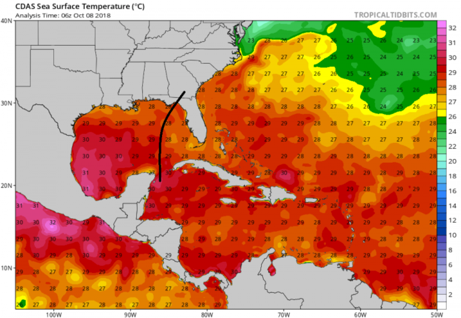
Another factor that might be at play in terms of potential fuel for Michael as it tracks north is how much it will churn up deep, colder water, which might put the brakes on any major rapid intensification. But, when unusually warm ocean waters extend to depths 100 meters or more below the surface, the hurricane’s winds simply stir up more warm water and allow dangerous and rapid intensification to occur if wind shear is low.
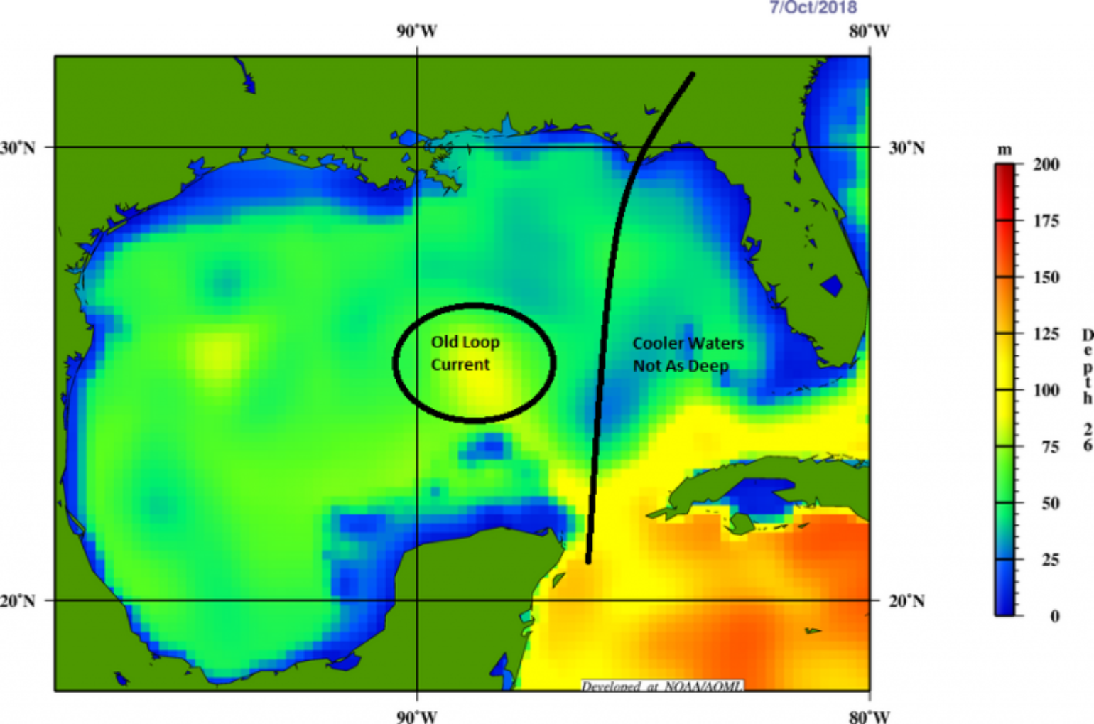
Michael will be tracking right over the deepest warm water, which is often referred to as the Loop Current -- an ocean current that transports warm Caribbean water through the Yucatan Channel between Cuba and Mexico. The current flows northward into the Gulf of Mexico, then loops southeastward just south of the Florida Keys (where it is called the Florida Current), and then goes west of the Bahamas as the Gulf Stream Current. Often, the Loop Current bulges into the northern Gulf of Mexico and sometimes will shed a clockwise rotating ring of warm water that separates from the main current. When this occurs, it can add even more fuel to passing storms.
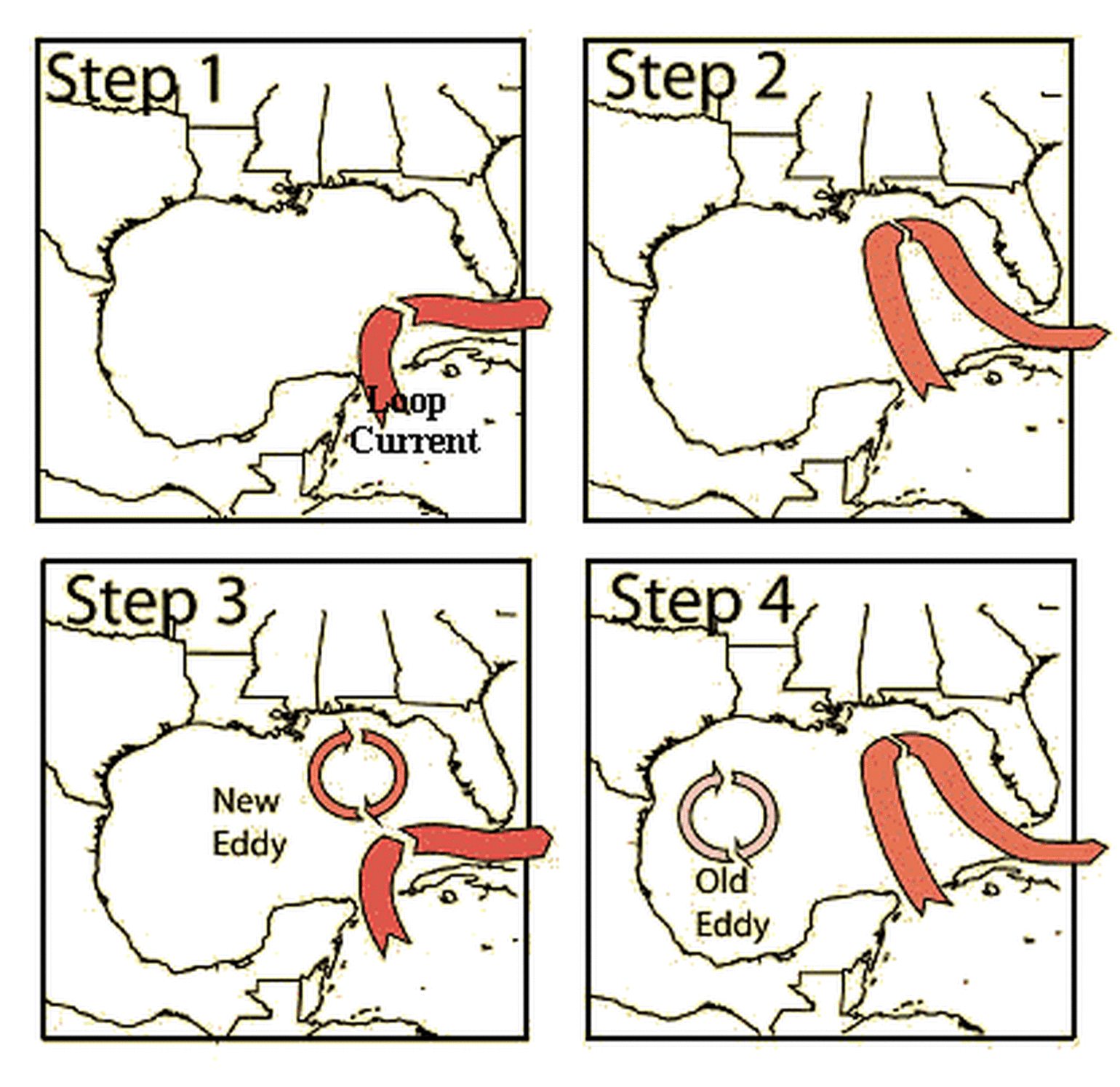
The good news is that it appears Michael will pass to the east of the last Loop Current eddy, which will limit some fuel for Michael as it tracks northward. But, this doesn’t mean that Michael won’t reach Category 3. It just indicates that the top-end intensity will be limited, as was observed with Katrina or even Harvey last year, which was fueled by an old Loop Current eddy.
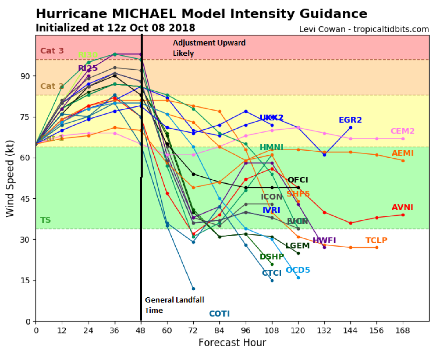
The other factor to consider that may limit intensity is the westerly shear near the storm as it tracks northward toward the Florida Big Bend Gulf Coast. However, despite 30 knots of wind shear, Michael has still managed to strengthen over the last 24 hours and has already had an impressive 982 mb central pressure. If wind shear weakens, Michael could continue to strengthen and potentially make landfall as a weak Category 3 hurricane.
No Stranger To Named Storm Activity
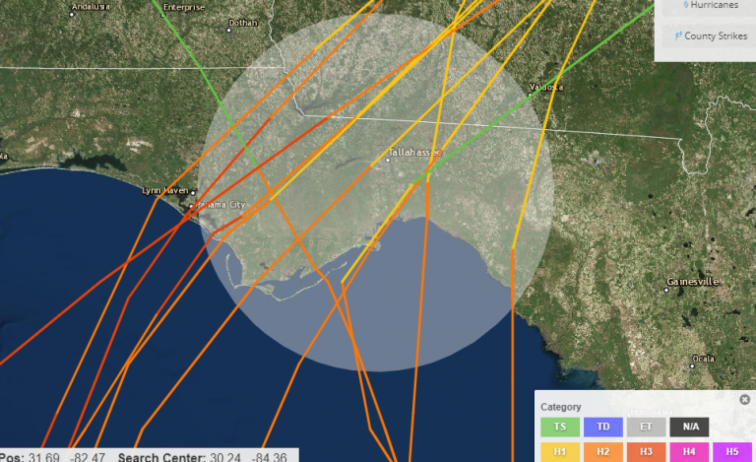
The Florida Panhandle has been no stranger to hurricane activity over the last three years. In fact, since 1850, 11 category 2 and 3 hurricanes have made landfall in the location under watch from Michael. The most recent being Hurricane Kate 1985 which today would result in close to one billion of industry loss. Subtropical Storm Alberto and Tropical Storm Gordon have already caused $168M of loss this year to the insurance industry to in the Gulf Coast States. The often forgotten Hurricane Nate in last year’s busy U.S. landfall season impacted the same general area with similar insured loss. In 2016, just over $200M in insured losses resulted from Tropical Storm Colin and Hurricane Hermine, which, as mentioned, might be the best overall analog for the industry at this time. In Florida, Hermine’s impact was enhanced by the natural bend in the coastline and abnormally high tides, with heavy precipitation along the Gulf Coast causing significant damage. In Citrus County, FL, one of the worst affected areas, 2,694 homes were damaged, of which 531 experienced severe damage. If you recall, the Big Bend area has a high tree density which, during Hermine, resulted in large number of power outages that stretched for weeks in locations all the way to the Tallahassee area, which was hit particularly hard with tree fall.
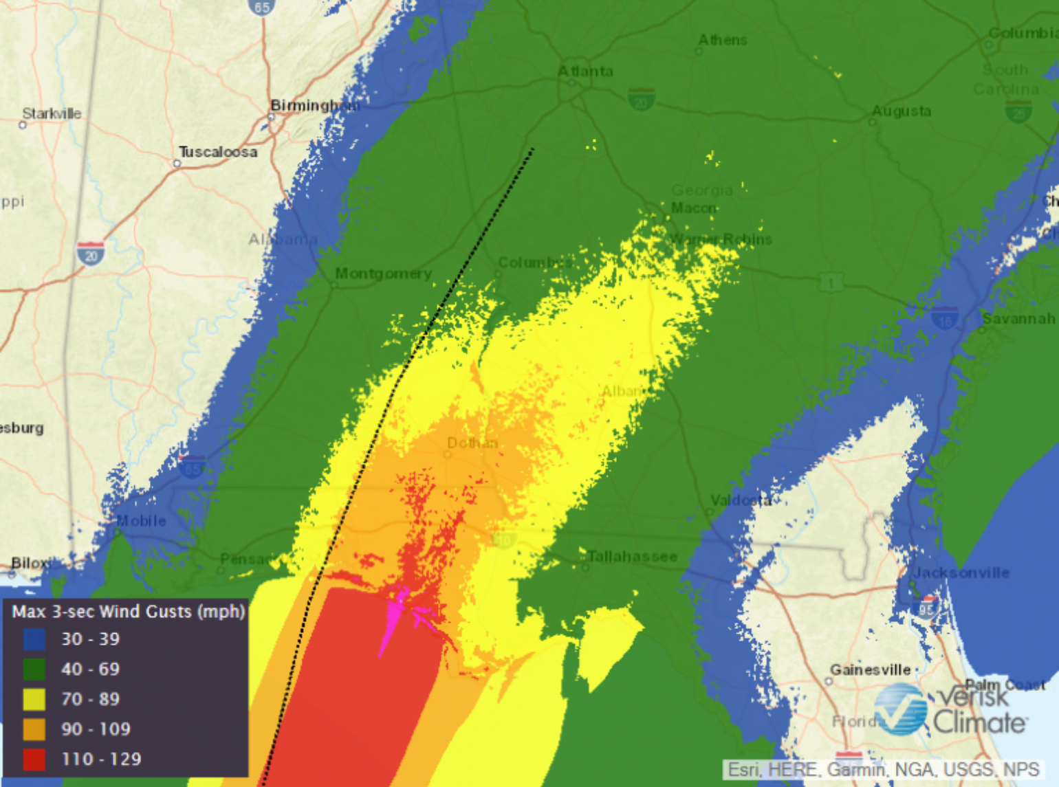
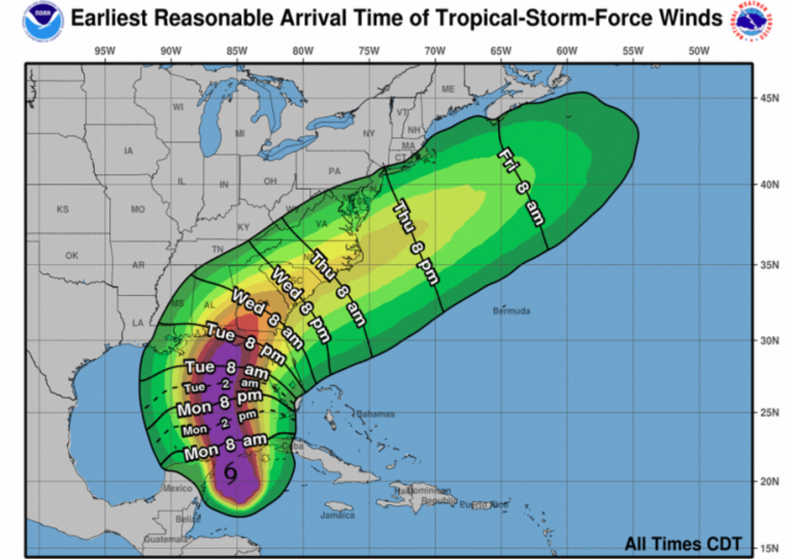
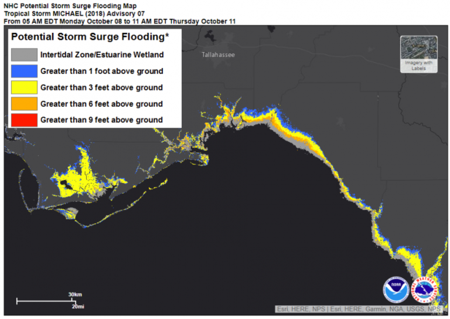
Michael’s impacts could be multiplied here since it is expected to be a major hurricane at landfall. The current model guidance suggests a landfall location between Miramar Beach to Apalachicola, FL, with the American GFS model suggesting a faster storm making landfall on Wednesday afternoon, while the European ECMWF model is predicting Thursday morning. However, regardless of timing, the insurance industry impact could be significant. The U.S. coastline between Indian Pass to Crystal River is one of the most vulnerable locations to storm surge. The current forecast suggests up to 11 feet of storm surge in this area, which could go even higher as Michael intensifies so don't be surprised if values above 11 feet start to show up in the forecast.
Unlike Florence, Michael will not linger and will move rapidly to the northeast across Central Georgia and southern South Carolina. There will be a swath of 4-8 inches of heavy rain just along and to the northwest of the center of the storm.
With a delayed autumn, all the leaves are still on the trees across a large portion of the southeast, which will exacerbate power outages. The highest wind gusts are expected along the coast from Destin, FL to Tayler and Wakulla counties and, as with Hermine, strong winds will have a big impact all the way into Tallahassee, which has the largest population area of the locations under threat, with the rest of the coastline being fairly rural.