Predicting a hurricane season is risky business, and a few egos may have taken blows this past season. That is, at least until April when the majority of 2019 Atlantic Named Storm forecasts will be made and the 2018 Atlantic season becomes a distant memory.
Almost all hurricane predictions from spring (including mine) failed, as they called for normal to below normal Atlantic Named Storm activity. Even the early August forecasts, which account for a good chunk of the hurricane season, failed to deliver.
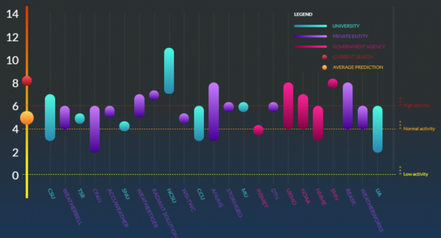
In total, there have been 15 Named Storms (30-year average is 12.1 Named Storms) – 8 hurricanes (6.4) and 2 major hurricanes (2.7). Accumulated Cyclone Energy (ACE) was about 124% of average seasonal activity. With four Named Storms resulting in nearly 10 billion dollars of insured loss so far, it was no doubt a costly season. When also considering the human toll along with too many broken meteorological records to mention, this season will be remembered for decades to come.
So what happened?
It appears that there are three leading reasons for this forecast bust, two residing in the oceans and one in the upper atmosphere.
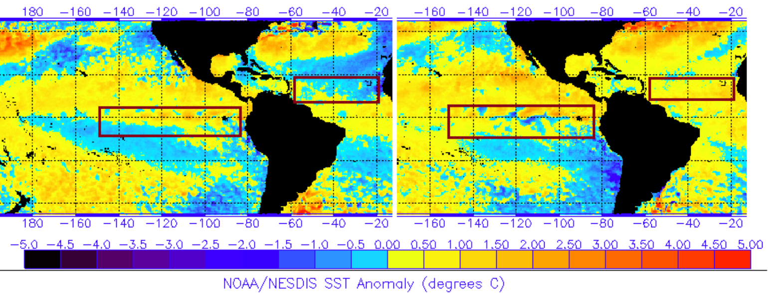
If you recall, there was a lot of talk about how cold the sea surface temperatures (SST) were across the Atlantic Ocean, particularly in the Main Development Region (MDR), from April through July. A lot of the seasonal forecasts believed that these notably cooler than average ocean waters in the tropical Atlantic would be likely to persist into the heart of hurricane season and keep the Cape Verde named storm activity in check, resulting in lower named storm counts overall. Instead, Atlantic SSTs warmed suddenly back to near normal in August. While still nowhere near as favorable as conditions in 2017 or 2005, this warming gave just enough lift to peak-season African easterly waves like the one that spawned Florence.
I would say the next reason would be on the failure for El Niño to fully develop in the central Pacific Ocean. If a stronger El Niño had developed, it would have helped increase the vertical shear over the Gulf and Caribbean. However, the SST stayed in neutral territory before lurching suddenly towards El Niño in early fall, which was a few weeks too late to spare the Florida Panhandle the worst of Hurricane Michael’s fury as it strengthened right up until landfall.
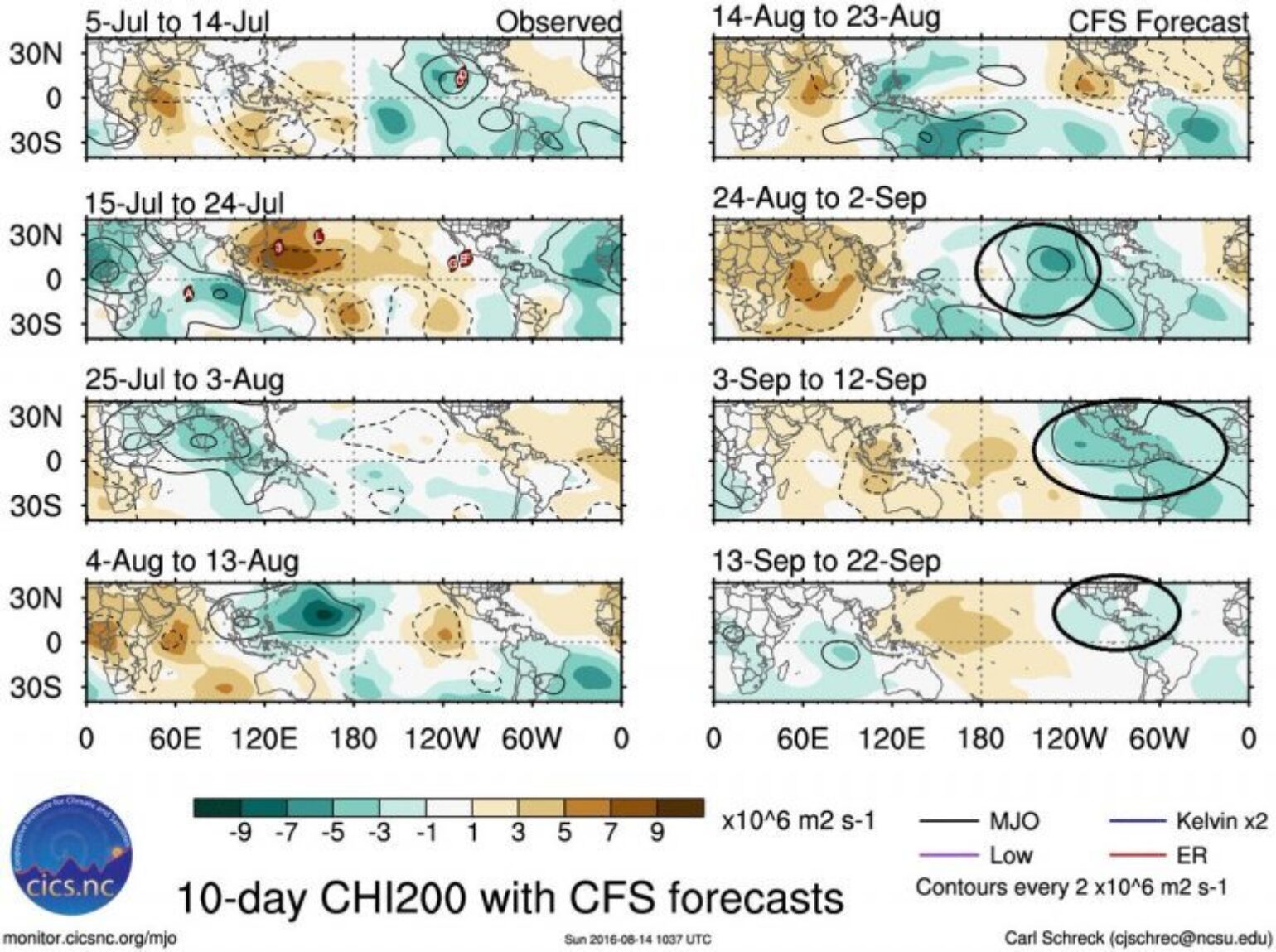
Lastly, looking back at the BMS Tropical Outlooks that were issued this past spring, they really pushed the fact that the Madden-Julian Oscillation (MJO) would be the key to the season, and pulses of activity would be key to new Named Storm development. It seems that the final factor contributing to the poor forecasting season would have to be the bad luck the MJO played in the timing of the overall Atlantic basin pattern. One of these strong MJO pulses coincided with both the primary climatological peak of hurricane season in early September and the secondary historical peak in early and mid-October. These MJO pulses explain why the 2018 season felt so “lumpy,” with long quiet periods punctuated by dizzying, multi-storm bursts of activity.
Lessons Learned:
There are many lessons to learn from the 2018 Atlantic Hurricane Season. One that might tie in well with the forecast bust is that there can be incredible variability during a hurricane season, which is why there needs to be less focus on the seasonal forecast numbers and more focus on interseasonal forecast, which can capture variables like the MJO and help define where storms may track when the activity starts. These interseasonal forecasts are performing well on a three-week time frame and can provide the insurance industry with insight on whether the period will be busy or quiet.
Speaking of forecasting, this past season was a great example that even the best forecaster in the world can’t nail down hurricane intensity even in a short-term forecast. Hurricane Florence and Hurricane Michael showed hurricane intensity forecasting has a long way to come. Three days before Florence made landfall, it was forecasted to be a gigantic Category 3 hurricane but ended up being a large slow-moving Category 1. Michael was only a tropical depression three days before landfall, and at the time was only forecasted to be a weak Category 1 hurricane. That's a long way from the storm that ensued, which was one of the strongest on record.
However, maybe all of this focus on the category of a storm should be another lesson to learn, as we experience time and time again that this focus can be too narrow. Insured impacts don’t revolve around the Saffir-Simpson Hurricane Wind Scale (SSHWS). As the name indicates, the familiar category scale is based only on a hurricane’s maximum wind speed, and thus sometimes fails to capture the true danger of large, slow-moving storms. When Florence dropped to Category 1 on its approach to North Carolina, some residents took the storm less seriously as a result, despite no decrease in flood risks. Alternatives to the SSHWS have been proposed, but in my opinion, all attempts to compress a hurricane down to a single number will have problems with oversimplification. Rather than discarding the venerable SSHWS, the answer could be as simple as expanding the role for overall hurricane threat and impact forecasts, which is the general purpose of the many BMS Tropical Updates provided before a storm makes landfall. The BMS Tropical Updates often try to break down the insured impacts of wind, surge, rain, and tornado risks that, with any hurricane, can range from minimal to extreme.
Another thing to remember and consider is that the forecast of a below normal or an above normal season doesn’t necessarily map to low or high chances of a hurricane landfall. With four named storms making landfall this past season, the insurance industry needs to keep its sights on the overall risk of named storm impacts. The catastrophe models are an important gauge to the overall risk during any given season. Seasonal hurricane prediction is an inexact science, and likely always will be. No matter what the numbers say for 2019, you need to look at the long-term risk and make slight risk management adjustments during the interseasonal forecast periods.
Resources:
Summary of 2018 Atlantic Tropical Cyclone Activity by Colorado State University
https://tropical.colostate.edu/media/sites/111/2018/11/2018-11.pdf
Hurricane Michael Damage Assessment
http://windhazard.davidoprevatt.com/hurricane-micheal-10-oct-2018-preliminary-assessment-by-steer/10/2018/
Hurricane Florence Damage Assessment
http://windhazard.davidoprevatt.com/steer-early-access-recon-report-hurricane-florence/09/2018/
Good Tweet Thread on the end of of the hurricane season by Michael Lowr
https://twitter.com/MichaelRLowry/status/1068491282027347968