With the peak of hurricane season just 12 days away, the tropical Atlantic is awakening right on cue. As we received the final advisory on Tropical Storm Chantal in the North Atlantic a few days ago, Tropical Storm Dorian was taking shape roughly 1,500 miles to the south in the deep tropics. Dorian is currently the only tropical system that should be of concern to the North American insurance industry, as recently named Tropical Storm Erin will be short-lived off the eastern coast of the U.S. and have minimal impact on the Canadian Maritimes.
The Bottom Line
The forecast models for Dorian are now showing Dorian will intensify as it travels east of the Bahamas. This is due to a much better environment which contains less dry air, lower wind shear, and warmer sea surface temperatures. The insurance industry should anticipate a stronger storm east of the Bahamas, as well as the possibility of Dorian making a Florida landfall as a major hurricane. However, it should be noted that the uncertainty in the forecast at this time is high with a mixed bag of possible outcomes, ranging from a weaker category 1 east of Bahamas to a major hurricane. While uncertainty is high, wind and rain impacts are possible in Florida later this weekend.
Dorian Forecast Details
In its long trek across the Atlantic, Dorian hasn’t been able to strengthen much because of dry air intrusion. Dorian has featured pulses of convection from time to time, but that convection hasn’t really been able to surround the center of the storm. Although Dorian will be passing over very warm water, the dry environment and a bit of wind shear could keep it in check over the next 48 hours.
There are several variables that will determine Dorian’s fate, but it seems that there are two critical periods. The first will be Wednesday night when Dorian will be in the vicinity of Puerto Rico. If Dorian passes over too much of Puerto Rico, it will interact with high mountains that could rip it apart. Restrengthening will take more time. However, if it just skims Puerto Rico, it has a better chance for survival downstream and will take less time to restrengthen.
The next critical period, sometime around Friday night, will be when Dorian moves into an environment which is more favorable for development as Dorian gets steered towards the east coast of Florida around an upper-level ridge. Some models indicate that there will be a broad upper-level trough to the west. Whether or not that hinders Dorian’s intensity with increased wind shear is a big source of uncertainty at this time and one of the only factors limiting the intensity forecast.
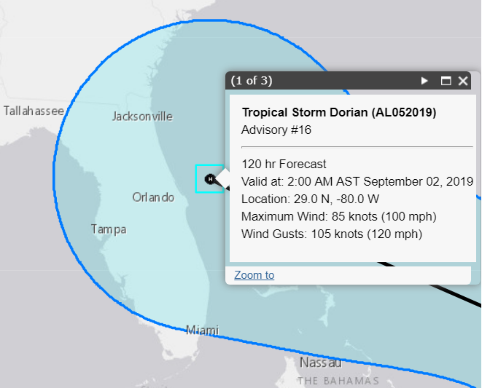
It’s really too early to be confident about a track forecast, so the current forecast by the National Hurricane Center is as good as any. That being said, the “cone of uncertainty” is over 400 miles wide at 120 hours, which is roughly the forecasted lead time for a potential Florida landfall. Also, the distance from Jacksonville to Miami is 347 miles, so a large section of the Florida coastline could potentially experience Dorian.
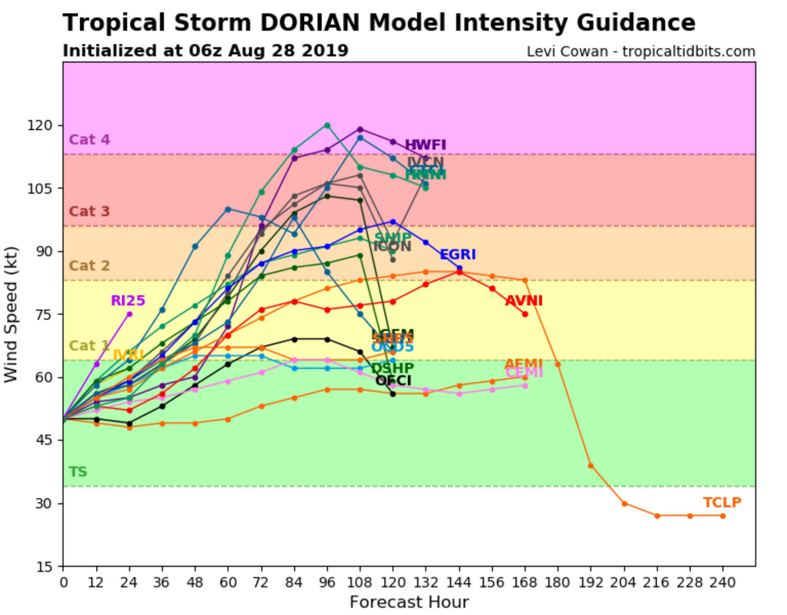
Intensity forecasts are tricky, and it’s much too early to speculate. Dorian could be an anywhere from a weak category 1 hurricane, with just heavy rain and minimal wind threat, up to a major hurricane. However, with the warm sea surface temperatures over the Bahamas and lower wind shear, a stronger storm should be expected and the trend in intensity forecasts over the last 12 hours suggests this.
Things To Consider At This Time
Although a Florida landfall has the highest probability (65%), the angle of landfall can make a big difference in impact. The angle will impact everything from storm surge to the wind along the coastline. Although much of Florida recently saw some sort of impact from Hurricanes Michael and Irma, not all areas experienced high winds. The angle of these high winds can create different outcomes, which is why the angle of impact is important. Of course, this will all depend on the strength of Dorian at landfall, which is unknown at this time.
Soil moisture could also be a factor. Coastal locations south of Cape Canaveral have been fairly wet, while points to the north have been dry over the last 30 days. We could see increased treefall if the higher winds occur where the soil is saturated, but the rainfall could actually be welcome news for points to the north.
With a new Super Moon occurring on August 30th, current tides will be running higher than normal which could increase coastal flooding and increase aspects of any storm surge that might occur.
With Dorian potentially making landfall over a holiday weekend, the amount of lost revenue from hotel and restaurants has the potential to be higher, which could increase business interruption in some cases.