Forecast Uncertainty and Verification
Let’s for a minute take a step back and think about when Dorian first became a tropical storm 725 miles southeast of Barbados. At that time the long-range five-day forecast from the National Hurricane Center (NHC) suggested Dorian would track over the Dominican Republic. As the NHC forecast advisories were issued, the forecast kept shifting north and east. As we know now, not only did Dorian miss the island of Hispaniola, but it missed Puerto Rico to the east and will now completely miss the southern Bahamas as well. When retrospectively looking back from when Dorian first became a tropical storm, its final track position was still within the far upper right part of the cone of uncertainty.
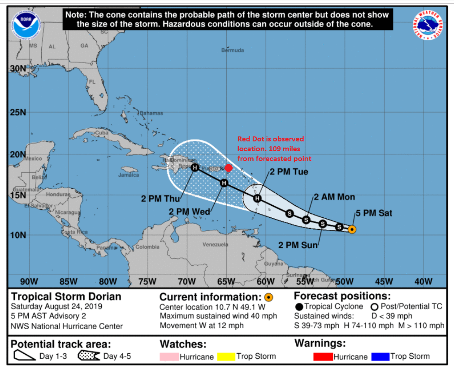
Over the last several days, the intensity forecasts issued by the NHC have been constantly revised upward and are only now starting to level off in intensity as a category 3 hurricane as Dorian approaches the Florida East Coast.
ToolsTo Help With Forecast Uncertainty
Because there seems to be a wealth of information flowing around Dorian, I want to share some publicly available tools to help determine what may be the best forecast models to help the insurance industry best narrow down the potential impacts from Dorian.
First, the NHC is historically one of the hardest forecast beat in both forecast track and intensity. The average track error from past storms makes up the cone of uncertainty they provide.
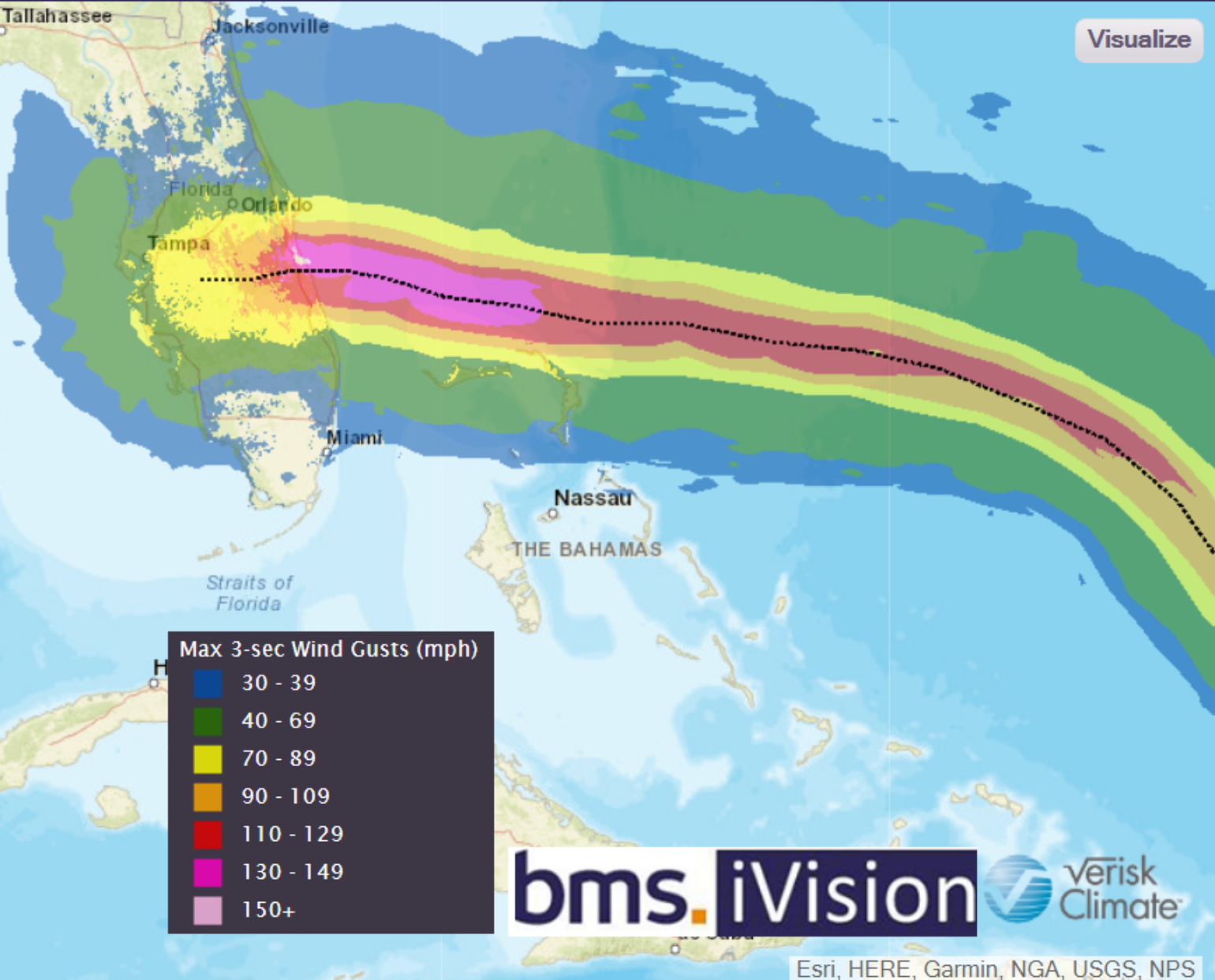
Second, with so many weather models in existence, it can become quite difficult to select which one to use. It seems each large government has its own forecasting model. There are also universities that run their own models and in some cases private companies run their own models as well (the latter is what Verisk Weather Solutions does, and what is used in our BMS iVision product which offers clients another view they might not be able to obtain from public sources). Even some reinsurance companies have at times run their own weather models, so there is no shortage of named storm track and intensity guidance.
All of these models offer up different paths and intensity forecasts which really adds to the overall uncertainty in an overall named storm forecast. Historically the European Center for Medium-Range Weather Forecast (ECMWF) has been one of the better long-range forecast models in terms of accuracy.
Third, some of these models actually run ensembles which are formed by taking slightly different initial conditions and/or model physics and integrating each of these ensemble members to generate a spread of possible outcomes. Since the atmosphere is a chaotic system, small initial differences can have profound impacts on the tracks and intensities of tropical cyclones at a future time. These differences will result in different model results. The ECMWF runs an ensemble that has 51 different members. That is a lot of different forecasts from just one model; therefore when using an ensemble it is best to pick the model consensus.
Fourth, Brian Tang, an associate professor of atmospheric science at the University at Albany, has developed some tools to help limit the uncertainty in named storm forecast by looking at model forecast skill in real-time. Professor Tang looks at various forecast lead times for forecast intensity and tracks. The tools may be found here.

Dorian Impacts
It is still too early to determine all of the impacts of Dorian. As highlighted yesterday, there are somethings to think about that are already known factors:
- The forecast is suggesting an increased confidence that a Florida landfall will be perpendicular to the coastline. This notion will be important in relation to the storm surge impacts and may result in higher inland wind impacts; however, it could perhaps result in an overall narrower area of impact to the insurance industry if the storm crosses the Florida peninsula.
- There is a chance the storm stalls over Florida, or moves much slower, which could enhance the wind and flooding aspects of Dorian.
- Soil moisture is already high across much of the state which could increase tree fall and power outages.
- With a new Super Moon occurring on August 30th, current tides will be running higher than normal which could increase coastal flooding and increase aspects of any storm surge that might occur.
- With Dorian potentially making landfall over a holiday weekend, the amount of lost revenue from hotel and restaurants has the potential to be higher, which could increase business interruption in some cases.