Miles Still Matter
As you read this insight this morning, think about the following fact: a Category 5 Hurricane Dorian, with winds of 165 mph, is stalled just 120 miles east of a population of around 4.6 million people. If you have ever had doubt that a storm capable of producing $200 billion in insured loss can't happen, this is a prime example that it can, as Mother Nature has no issue creating such a strong storm near the southern Florida coastline.
Sunrise #Dorian pic.twitter.com/hBkKLABfIc
— Greg Diamond (@gdimeweather) September 2, 2019
Similar to Hurricanes Matthew in 2016 and Irma in 2017, the insurance concentration of southeast Florida appears to have once again escaped catastrophic damage. However, that has not been the case for the Bahamas as the devastation will likely continue for the next 24 hours as Dorian is stalled over the area.
More videos coming from the Abaco Islands from the devastations by Hurricane Dorian....this is complete heartbreak. Prayers to all. 😥🙏🏽 #hurricane #hurricanedorian #Bahamas #242 pic.twitter.com/lfvM4dzQtv
— 🇧🇸James Julmis🇧🇸 (@julmisjames) September 1, 2019
Dorian is setting all sorts of records. There are too many to mention here, but if you are interested, have a look at the twitter feed of Philip Klotzbach from Colorado State University where he lists such records and other facts about this storm. One of the most impressive facts about Dorian is that its winds are the strongest (185 mph) this far north (26.6 degrees N) in the Atlantic ever recorded.
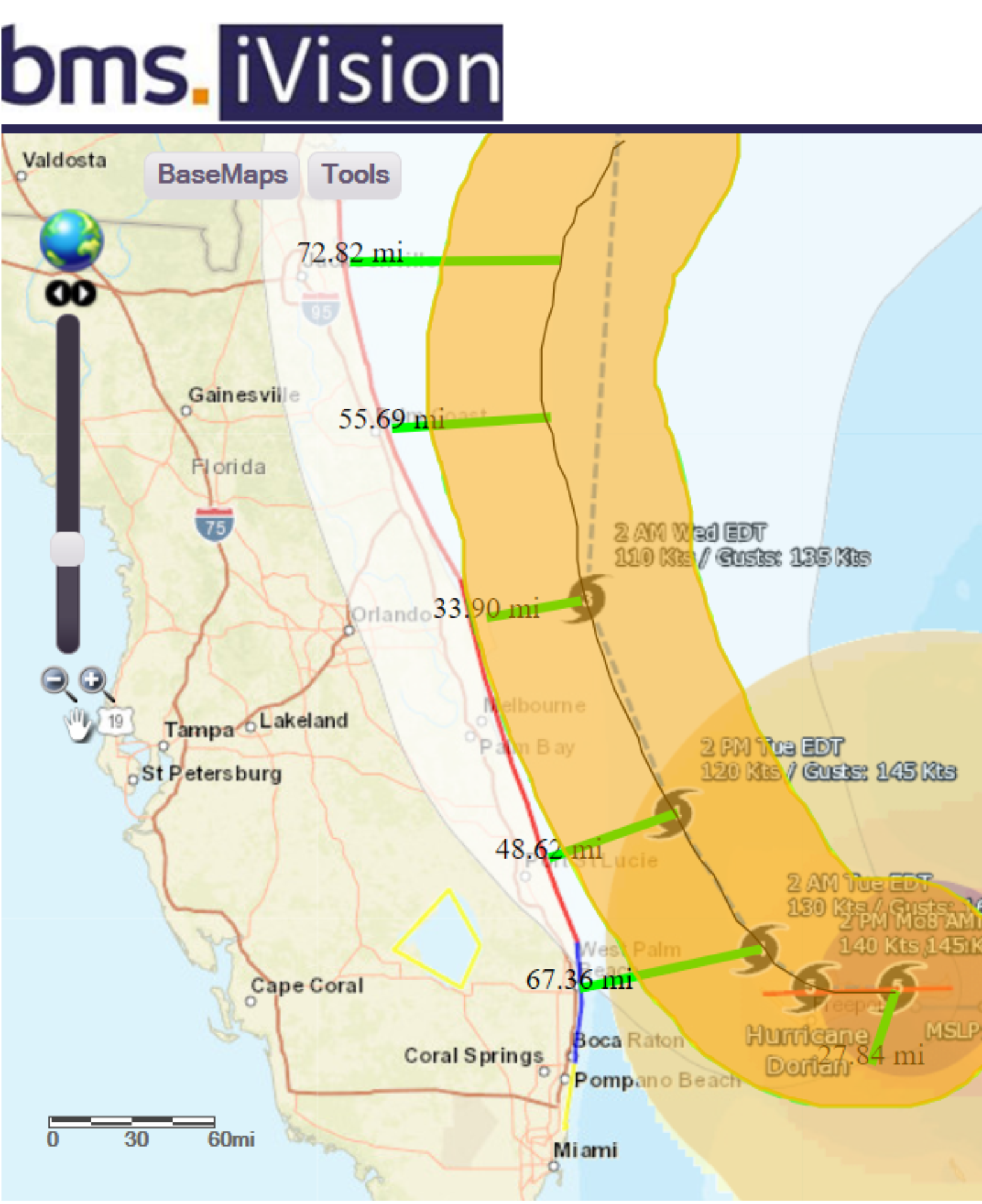
As forecasted over the last several days, Dorian has all but stopped its westward motion overGrand Bahama Island. Very little movement is expected today before Dorian starts to move north-northwest. The sharpness of this turn north remains a huge question and will ultimately decide how much of Florida and the southeast coast of the U.S. experience hurricane conditions.
Currently, Dorian’s maximum speed winds are eight miles north-northeast of the center of the storm. But with hurricane-force winds only extending out from the center of the storm on its southwest side to about 27 miles, Dorian continues to be a small storm. As Dorian turns north it is expected that a few eye-wall replacement cycles could occur. That means that the overall maximum wind would come down a bit, but the wind field will expand in size; but by how much is unknown. The strongest winds of an Atlantic hurricane are generally on its right (east) side; the winds on the left (west) side of a hurricane are almost always weaker and have less extent from the center. Therefore, as mentioned over the last few tropical updates, the distance from the coastline that Dorian tracks will matter.
A Break Down Of Dorian Impacts
Wind
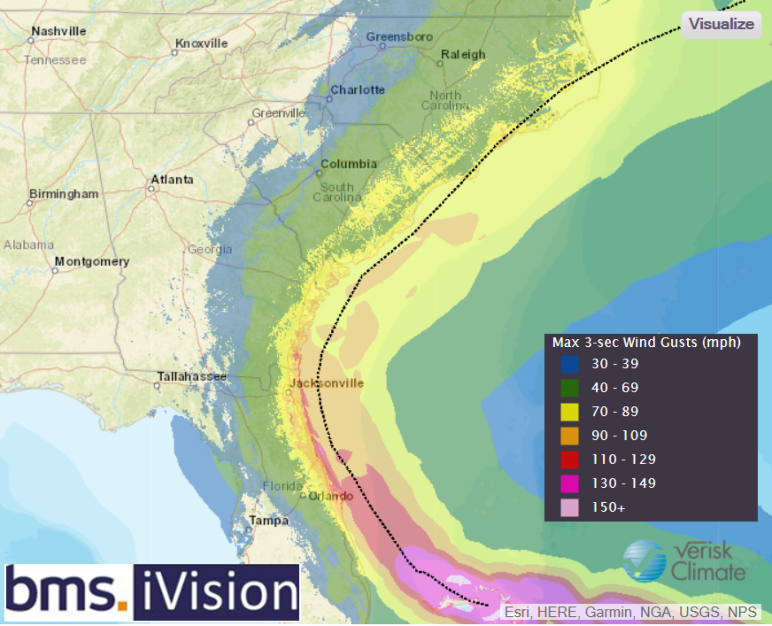
Once Dorian starts it north-northwest movement up along the Florida coastline its forward speed will likely continue to be slow, which could increase insured loss as prolonged high wind speed can also increase damage. However, hopefully homes along the coast are also built to higher standards.
Tornado
The U.S. has had an above-normal tornado year and I expect some tornadoes to occur with Dorian to add to this total count. The area where tornadoes often form in a hurricane is in its northeast quadrant, but it does not mean they can’t form on the west side of a hurricane. How severe the tornado threat is will again depend how close Dorian tracks to the coastline.
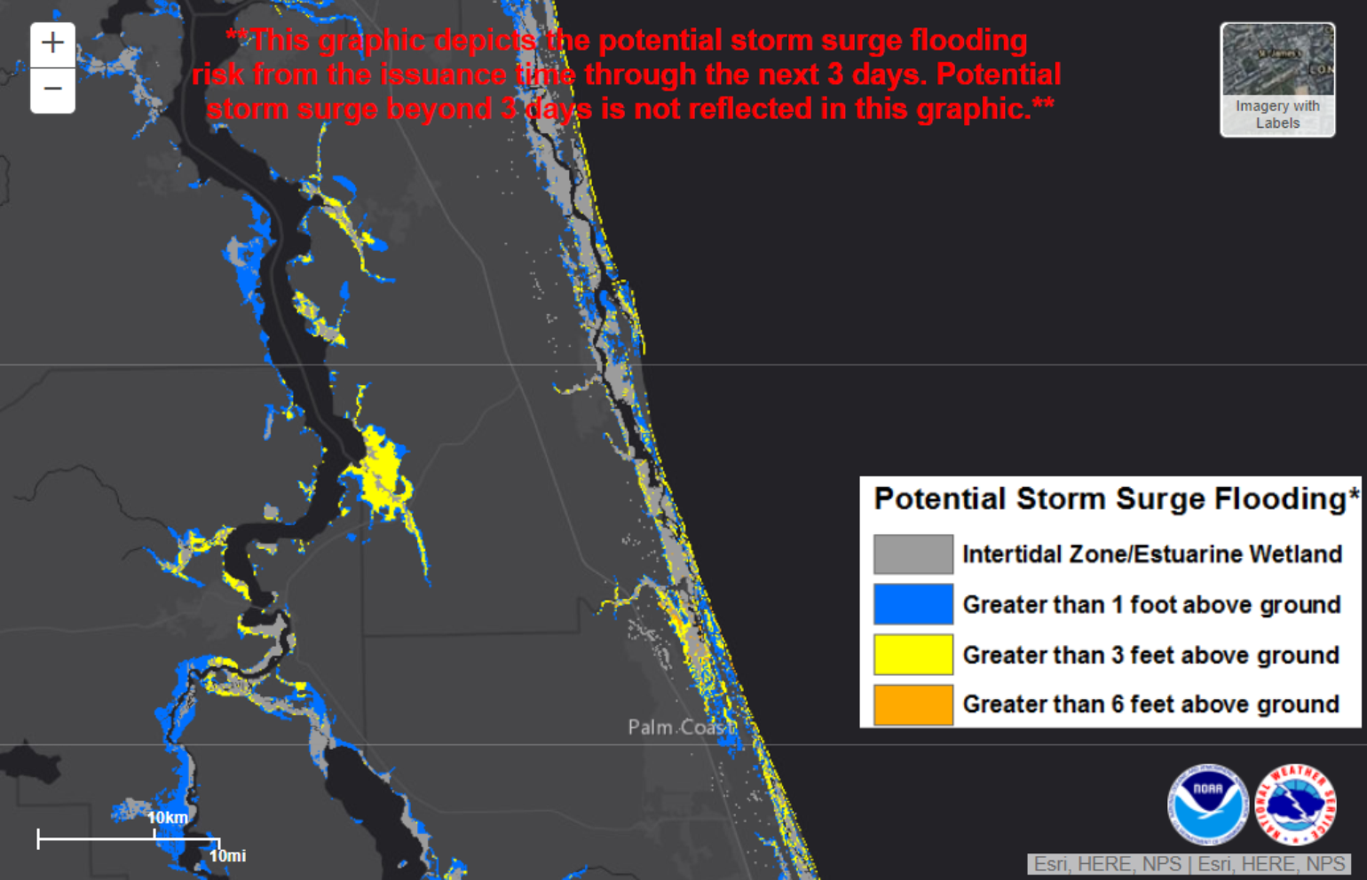
Storm Surge
The east coast of Florida is, for the most part, not as susceptible to storm surge as the west coast of Florida. However, there are many inland waterways along the east coast that will have an increased risk of storm surge, but since Dorian is not forecasted to push inland perpendicular to the Florida coastline the risk is mitigated to some extent. The NHC has now started issuing high-resolution storm surge flooding inundation maps that represent the storm surge flooding over the next few days. The current forecast shows the most significant flooding concern in these waterways resulting from the very high waves that are expected over the next several days as the storm produces intense swells in excess of 30 feet as it moves north and then northeast. These waves will likely also produce dangerous surf along ocean-facing beaches, beach erosion, and potential coastal flooding given the extremely high tides this weekend.
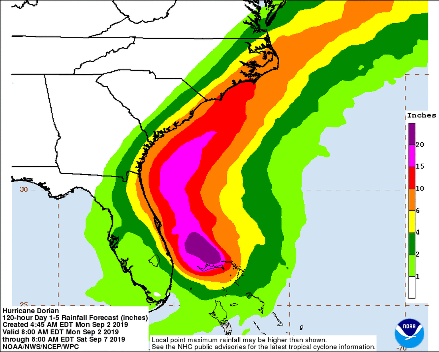
Flood
Dorian is expected to produce very heavy rainfall, with some locations across the Bahamas seeing more than three feet of rain due to the stalling nature of the storm. Across the U.S., some locations could see six or more inches of rain where Dorian tracks closest to land. Given the uncertainty in the track, it is still unknown which areas would receive higher amounts of rain. If Dorian tracks very close to shore or makes landfall, more significant rain could occur across the Florida peninsula and along the Southeast of the country. However, if Dorian remains further offshore, most of the heaviest rain would remain away from land.
Long Range Forecast
There is much more certainty in the long-range forecast now. Dorian will likely not make U.S. landfall and should track along Georgia, South Carolina, and North Carolina coastline. By Wednesday, the storm will be approaching the latitude of Jacksonville, Florida and will probably begin turning to the northeast in response to an advancing mid-latitude trough. This turn will likely bring the storm very close to Georgia, South Carolina, and North Carolina. On Friday morning, the storm will be departing the area close to North Carolina and heading to the northeast as it transitions into a powerful extratropical cyclone in the North Atlantic. The storm may pass close to the outer banks of North Carolina and up to Cape Cod, Massachusetts, but it’s far too early to tell what the extent of those impacts might be until we see how close the storm will track to the U.S. coast.