The Official Start to Atlantic Hurricane Season?
In theory, the Atlantic hurricane season started late last week with the naming of subtropical storm Alberto. However, interestingly, prior to 2002, subtropical storms were not given names, even though the National Hurricane Center would issue forecasts and warnings for them. Since 2002, such storms have been given names from the tropical cyclone list (Gustav in 2002 was the first). Taking that into consideration, and since no tropical storm days and no Accumulated Cyclone Energy (ACE) have been recorded yet this year, the season, perhaps, has not quite begun.Regardless, June 1 is the official start of the season and, therefore, providing a bit more detail in regard to expectations for the 2018 Atlantic hurricane season and its impact on the insurance industry is timely. As I mentioned in the closing of the last BMS Tropical Update, there is no relationship between the date of the first Atlantic named storm formation and overall Atlantic seasonal hurricane activity.
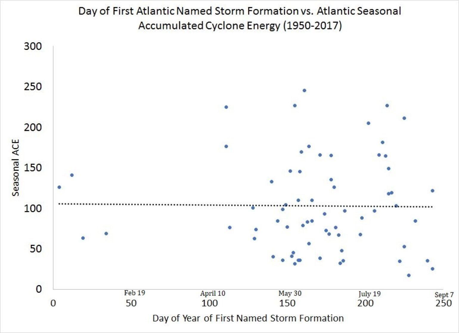
Since 1950, there is no relationship between date of first Atlantic named storm formation and overall Atlantic seasonal hurricane activity. Source: CSU
Over 18 different companies and organizations produce seasonal forecasts for the Atlantic hurricane season and are tracked by the Barcelona Super Computing Center. Just last week, NOAA issued its outlook for the season, with a wide range of a 70% likelihood of 10-16 named storms for the 2018 season. When reviewing the historical record, 55% of all hurricane seasons fall into this range, however, which doesn’t provide much informational value to the insurance industry.Seasonal hurricane forecasts generally come in one of two methodologies: statistical/dynamical models vs. educated guesses from people interpreting the models that produce analog years. The models can be trained and tested against previous years to provide either uncertainty or confidence. The educated guessing is prone to human bias, rules of thumb and big wins or losses. Although there is a general correlation between the greater number of named storms that occur in the Atlantic Basin and the higher chance of landfall, very few forecasts go beyond producing Basin-wide activity to predicting specific impacts or landfall forecasts. To illustrate this point, even if 16 hurricanes were to develop in a season, but none ever hit land, the hurricane season would be classified as above-average, but one that costs the insurance industry nothing in paid losses. Conversely, if three hurricanes develop and all hit land, it’s a below-average hurricane season that could cost the insurance industry millions. I believe there needs to be some attempt to connect the basin activity with landfalls in order to increase the value of utilizing such forecasts.
Where could storms track this season?
One of the most common climate forcers used for seasonal Atlantic Hurricane activity is the El Niño Southern Oscillation (ENSO) and, this year, there appears to be agreement that a weak El Niño event will take hold during the summer, which historically suppresses hurricane activity in the Main Development Region (MDR) of the Atlantic Basin due to higher wind shear. If the El Niño is weak, it could shift development of named storms further north and into the western part of the Atlantic basin near the U.S. East Coast thus increasing landfall chances. Historically El Niño, has little to do with activity in the Western Caribbean / Gulf of Mexico, and any activity in this region increases the chances of U.S. landfall.
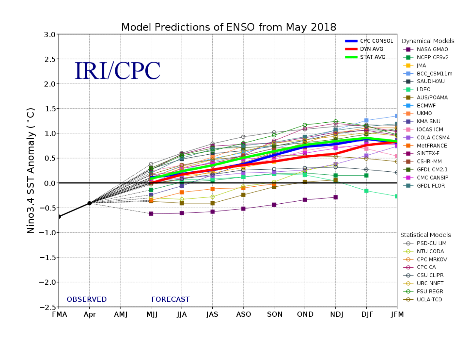
Various models from IRI and NOAA CPC on the SST prediction in the Central Pacific ENSO region 3.4. Notice the ASO forecast suggest a weak El Niño should be developed with SST anomaly at 0.5C.
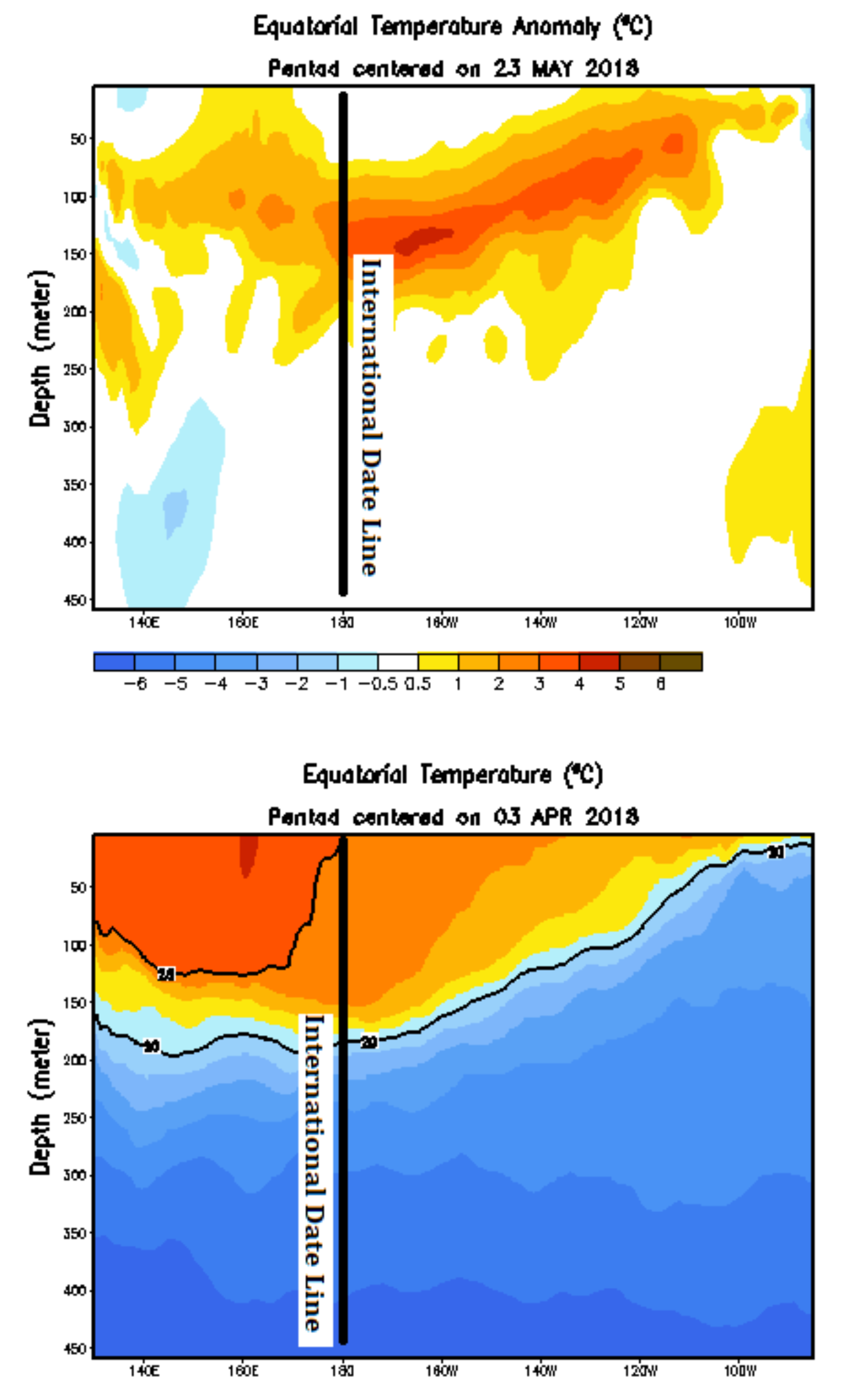
View from NOAA CPC ENSO analysis of subsurface temperature anomalies across the Central Pacific showing overall anomaly below the surface at 150m. This warm water should rise to the surface over the next few months building the chances of an El Niño during the season.
The subsurface water temperature anomalies across the Central Pacific are warm, suggesting a developing El Niño similar to a Modoki-like Niño, which also points to higher landfall chances during a hurricane season.Yet another climate forcer taking center stage in early season hurricane forecasts is the cool Atlantic Sea Surface Temperature (SST). In fact, the current North Atlantic SST anomaly pattern looks to be the opposite of an SST pattern which, historically, would be associated with an active Atlantic hurricane season, and could potentially be the coldest since the summer of 2015. However, in the plot below, the warmest SST relative to the average temperature is observed above 30 degrees north latitude and warms closer to the eastern coast of the U.S. This type of pattern suggests that development of stronger named storms might not occur this season in the MDR, but instead north and closer to the U.S. coastline or in the Bermuda Triangle Region of the Atlantic. It should be noted, however, that the MDR Atlantic SST will ultimately trend warmer; almost every year since 1995, the general SST in the MDR has warmed by August regardless of how cold it was in May.
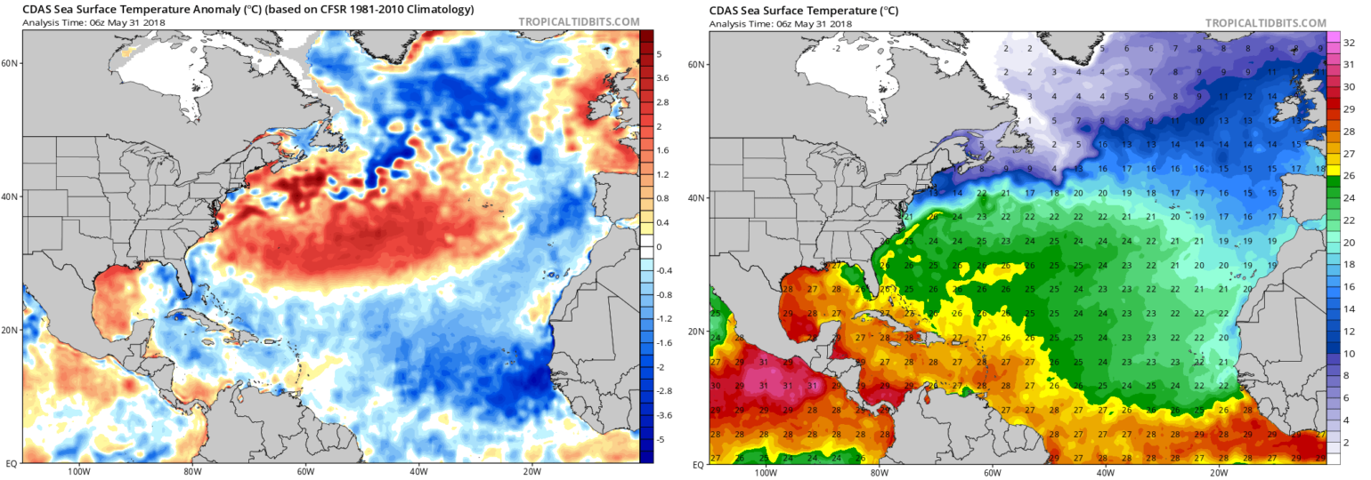
Left is the current SST anomaly and the right the current SST. Reminder, named storms need at least 26C to maintain development. Currently these types of temperatures are hard to find and likely not a great depth below the surface.
While acknowledging that global weather patterns can change toward the peak of the hurricane season, we can, at a minimum, surmise what the current named storm tracks might be based on the current position of the Bermuda - Azores high pressure center across the Atlantic Ocean. Named storms will often traverse the Bermuda - Azores, and this might provide some clues about the track of future hurricanes in the Atlantic. In its current state, we can see that storms will steer further west, increasing U.S. landfall chances. But if the high weakens to the east, storms may track off shore.
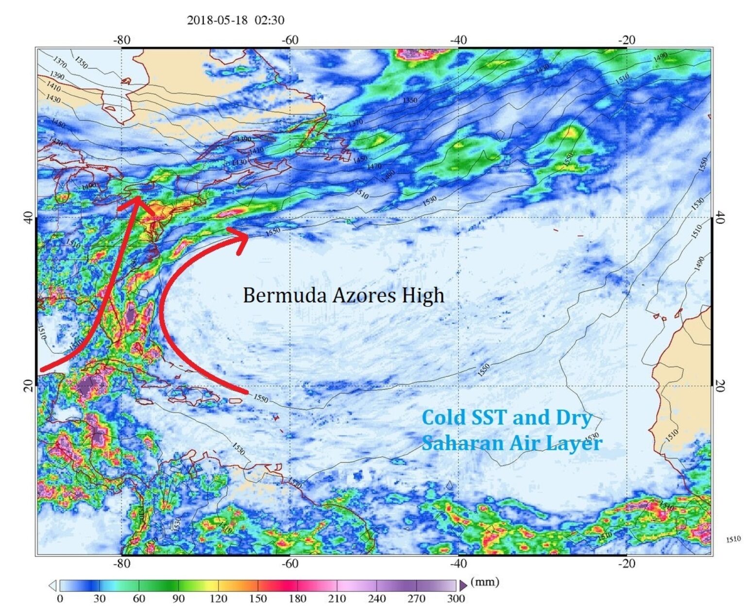
An enormous blocking atmospheric pressure ridge over the Atlantic Ocean stayed resilient for days, which prevented precipitation systems from propagating east. Source NASA GES DISC[/caption]Two other climate forcers to watch this Atlantic hurricane season will be Saharan dust and the Madden Julian Oscillation (MJO). Both of these climate forcers are difficult to predict seasonally, but understanding the phases during the season could help determine when storm development will occur. Saharan dust can be an inhibitor of Atlantic hurricane activity, but often moves away from Africa in waves.
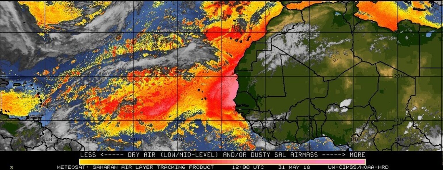
Current level of dust off the coast of Africa. Breaks in this dust need to be watched over the given season. Source: http://tropic.ssec.wisc.edu/real-time/salmain.php?&prod=splitE&time
During the breaks in dust, the potential for the genesis of named storms is likely and, if combined with a positive phase of the MJO, could pose a threat to the insurance industry. In fact, I would speculate that the MJO was recently in a state that enhanced tropical convection, which assisted Alberto’s movement across the southwest Caribbean last week. If the MJO was in a favorable state, then we are just moving out of a positive phase for the Atlantic Basin, the next one not occurring for another 45 days. Therefore, this cycle is something to watch closely during the 2018 season, as both of these climate forcers could be the catalysts for named storm development.
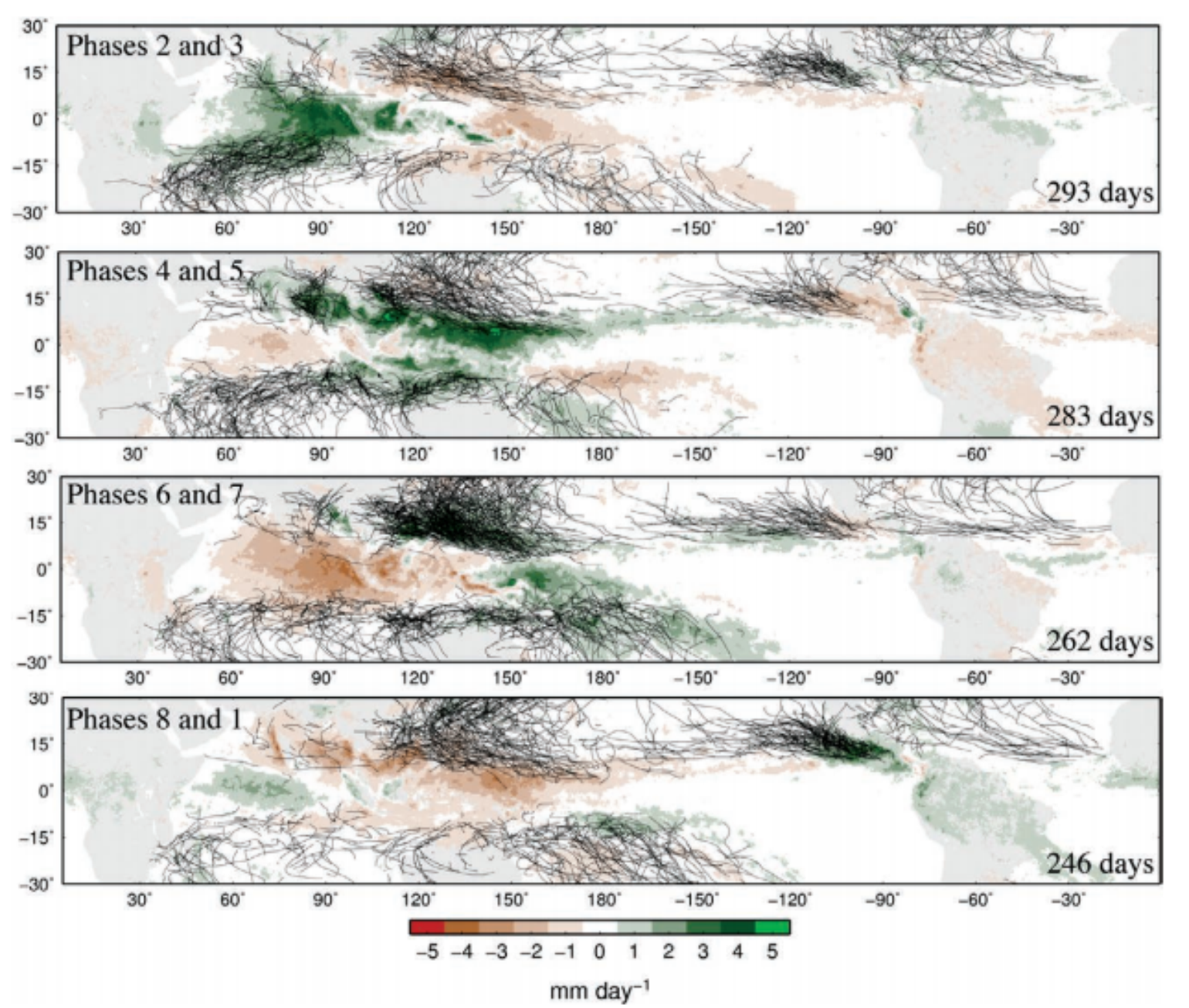
The MJO can also considerably influence hurricanes in the Gulf of Mexico, Caribbean Sea, and tropical Atlantic. More hurricanes tend to occur in MJO phases 2 and 3 than in phases 6 and 7. Differences in major hurricane numbers and hurricane days in the main development region are a factor of 3. Source: https://journals.ametsoc.org/doi/pdf/10.1175/BAMS-D-12-00026.1
Summary:
It seems that, based on the information above, the forecasts from various organizations show a reduction in the overall numbers of named storms and hurricanes, thus indicating a less active season. However, even in quieter years like 1989 (Hugo) and 1992 (Andrew), there can be storms that have great impact on the insurance industry. The climate forcers and analog years (1934, 1951, 1996, 2002, 2006, 2009, and 2011) suggest less strong storms over the MDR, but as named storms or tropical waves track out of the MDR the could become stronger as they more reach northern latitudes. The climate forcers and analog currently indicate named storms could track closer to the U.S. coastline increasing the chances of insured loss. However, since 1920 there are only 16 years in which two or more hurricane made landfall in one season that have resulted in two or more landfalls the next season.Given the state of the MJO and the cooler Atlantic SST, I don’t expect a lot of new named storm activity for the month of June. But, during the first part of the July, the MJO could return to a more favorable state over the Atlantic Basin, which will allow for a reassessment of future hurricane landfall possibilities.
Resources:
Barcelona Supercomputing Center has a nice summary of the various Atlantic Hurricane Forecastshttp://www.bsc.es/seasonalhurricanepredictionsNOAA Climatology Products – Avg Start Dates, Return Periods, Develop Origin by Date, Strike Densityhttp://www.nhc.noaa.gov/climo/CSU U.S. Landfalling Hurricane Probability Projecthttp://www.e-transit.org/hurricane/welcome.html