By Andrew Siffert – Vice President / Senior Meteorologist
Everyone likes a parade right? Well, maybe not the tropical variety that looks to be occurring in the Atlantic Ocean now. The National Hurricane Center (NHC) is watching three different tropical systems with more West African Waves forecasted to come off the coast of Africa over the coming week.
The Atlantic surely looks like it is now entering into an active two week period that coincides with large scale upward motion allowing for a better overall environment for named storm development.
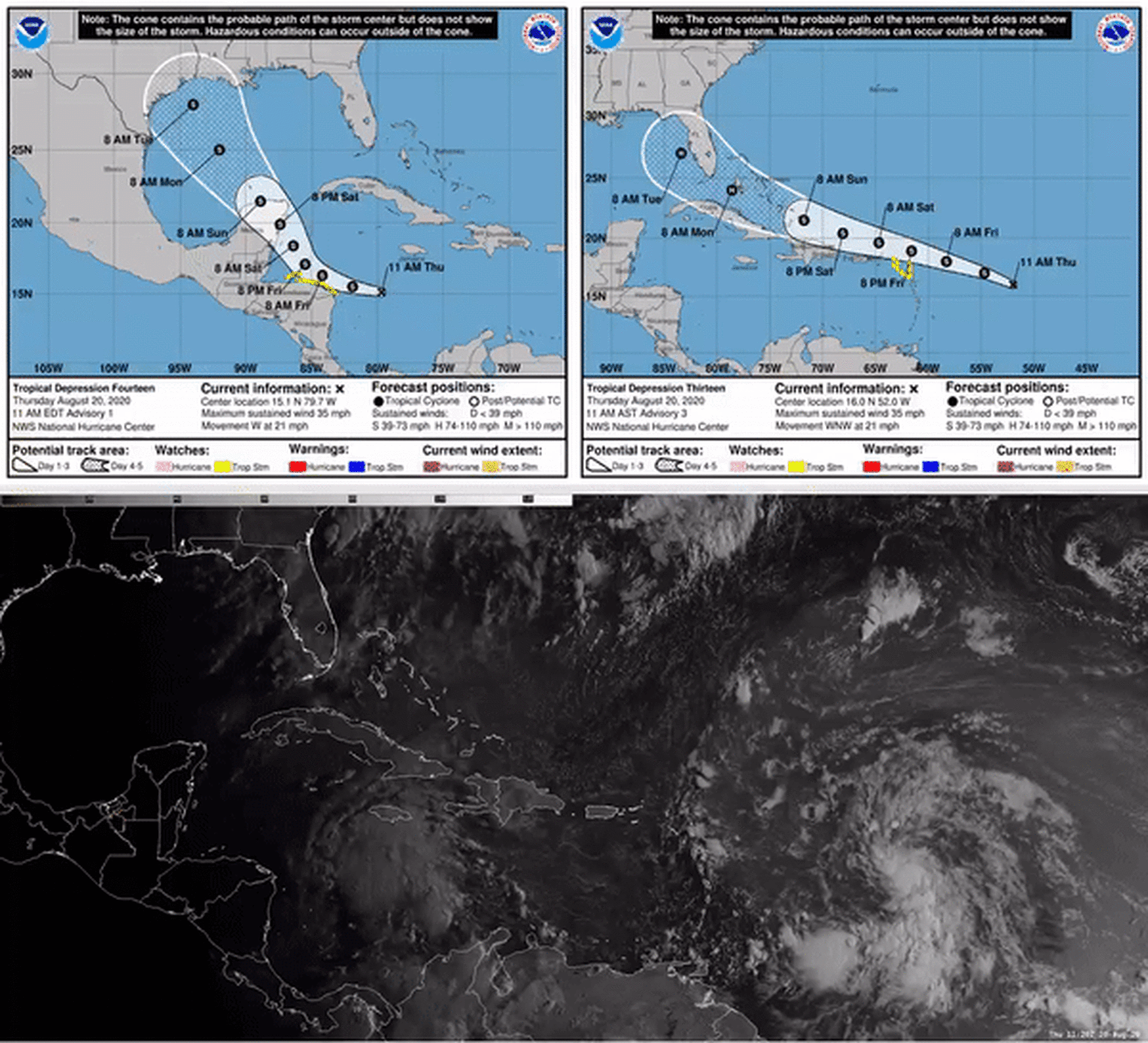
The most concerning tropical system in the parade is Tropical Depression 13 (TD 13) which formed in the central tropical Atlantic last night. If it gets named, which is very likely in the next 24 hours, it would be named Laura. The current record for the earliest “L” Atlantic named storm is Luis on August 29th, 1995. The Atlantic has already had 11 named storms and most were the earliest forming for their respective letters. While the 2020 Atlantic season has named 11 named storms, the Accumulated Cyclone Energy is only the 10th highest in the satellite era. However, landfall impacts have already reached into the billions of U.S. insurance losses with Bertha, Cristobal, Fay, Hanna, and Isaias.
Tropical Depression 13
TD 13 is very close to becoming named storm Laura and the overall environmental conditions are looking fairly favorable for weak intensification over the next few days. There has been considerable model spread in intensity over the last several days with this tropical wave. This is due to weak shear and drier air around the system, which will continue to persist for the next 48 hours or so. As in the past with Isaias, TD 13 also has the potential interaction with the higher topography of Puerto Rico and Hispaniola in the coming days; but, if the storm can navigate the course, major trouble could occur to the U.S. insurance industry.
Below shows the forecasted tracks clustered tightly over the northern Caribbean Islands early Saturday, near Hispaniola on Sunday, and then Cuba/Florida/Bahamas on Monday into Tuesday. Come Monday and Tuesday the overall atmosphere and ocean conditions look to be primed, so it is very possible that the storm could be stronger than the current forecast by the NHC (Weak Category 1 Hurricane). In fact, if the storm is north of Cuba, the only limiting factor on intensification appears to be time over open water.
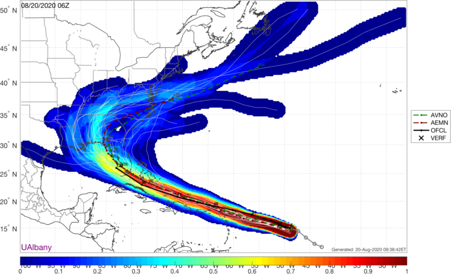
The troubling problem over the last several days now appears to be how the world-leading European global model ECMWF really does not want to develop TD13 into a stronger storm with very little model support of anything stronger than a tropical storm after Monday. While the American global model (GFS) and its ensembles (shown above) have had many runs that show it at hurricane intensity by Monday. A forecaster should never model flip flop and trusting the model skill of the ECMWF is hard to pass on, but this is a real test as to which model will be right. It should also be noted there are other forecast models that support a stronger storm come Monday, so the ECMWF is the outlier here. This is also when a forecaster just has to trust their gut about what the overall environment says should happen versus what a model says should happen.
So could a major hurricane develop after Monday which is interestingly enough the anniversary of the South Florida landfall of hurricane Andrew in 1992? Sure. The global model guidance suggests a named storm will be tracking along the only section of U.S. coastline that has not had a tropical threat this year, West Florida Coast and Northern Gulf Coast states, so everyone just might get a good view of the parade of storms this year. However, the intensity is the big question mark. Environmental conditions will be prime for a strengthening system if the system can pass through the Straits of Florida into the Gulf of Mexico. The overall impact of a named storm on the U.S. coastline is very high at this point with a 90% chance. The odds of a hurricane are 50% with the highest odds of a hurricane impact coming to the north Florida coast at this time later next week. A strong hurricane off the Florida West Coast is very possible early next week, but let's hope the ECMWF is the winner here and there is nothing to worry about besides a tropical storm at this point.
Parade Race
Currently I think TD 13 will likely reach the “L” letter faster, but the other area that needs to be watched is Tropical Depression 14 currently over the central Caribbean Sea. There might be a bit of a race as to what storm becomes Laura and which storm is Marco, making this parade a race even more exciting to watch. The general idea is that TD 14 becomes a tropical storm very soon and track toward the Yucatan Peninsula, but there is some model support that the system stays lower in latitude and interacts with Honduras and does nothing. At this time the longer-range guidance shows if the storm is north of Honduras it will be located in a favorable environment for further development with the biggest limiting factor being proximity to land.
If the center wobbles onshore over Honduras, Belize, or the Yucatan Peninsula of Mexico, it will weaken and may not have much of a chance of significant development even after it eventually emerges into the Gulf of Mexico. If the center remains offshore, it will have a much better shot at taking advantage of the favorable environment and becoming a stronger storm.
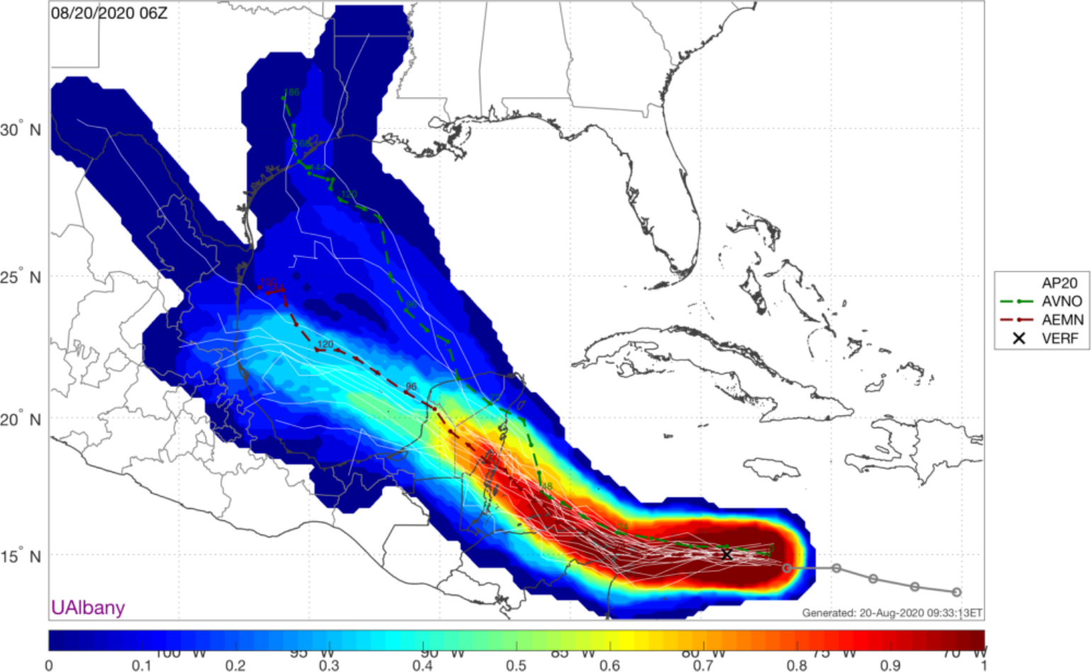
Much like TD 13, there is considerable model spread on the intensity and even more so on the forecasted track with TD 14. Therefore, at this time, the overall confidence in the future of TD 14 is low with a low probability of U.S. Impact (10%), but the insurance industry needs to keep an eye on this system as there is a chance that two named storm could be making landfall along the Gulf Coast of Florida next week.