By Andrew Siffert – Vice President / Senior Meteorologist
Marco Downgraded
The notion that two dueling hurricanes will be making landfall in the same general area seems to be off the table as late last night Hurricane Marco was downgraded back to a tropical storm. As discussed in the tropical update yesterday, wind shear and dry air have been providing a less than ideal environment for Marco to strengthen, even though the Gulf of Mexico Sea Surface Temperatures (SST) are above normal and can support the development of a major hurricane. Very similar to Cristobal earlier this season the deep convection is well northeast of the center of the circulation resulting in a lopsided tropical storm with the biggest impacts displaced from the center of the storm. This is creating heavy thunderstorm activity over the Florida Panhandle. There are early signs that Marco’s upper-level features are starting to decouple with the low-level surface circulation. Unless Marco can fire some new deep convection around the low-level center the NHC will have to further downgrade the system before landfall later this afternoon.
Since Marco is not as intense as forecasted yesterday it will likely track right along the Louisiana coastline and not as far inland as forecasted yesterday. The overall extent of its tropical storm force winds are quite small. Since it is smaller than Cristobal the overall impacts should be less than Cristobal which had an insurance industry loss of around $150 million. Of course, if Marco can fire some deep convection later today near its low-level center some stronger thunderstorms will be offset to the northeast of the center over more populated areas such as New Orleans and the cities along I-10. This could bring gusty winds that should be manageable for many properties which have likely seen stronger thunderstorm force winds from normal severe weather or more recent named storms to impact the area. Heavy rainfall (3-6") along portions of the Louisiana coastline still appears to be the biggest impact that will cause flooding in low-lying areas, but again many of these coastal areas are no stranger to heavy rainfall events. Marco does not appear to be a major flood event for an area which has seen some pretty big flood events with recent named storm impacts. At this time, storm surge looks to be much less than forecasted yesterday. Now that Marco has weakened and the current National Hurricane Center (NHC) guidance shows a storm surge of less than 3 feet along the Louisiana Coastline, as well as the smaller overall size of Marco, the storm surge should not be an issue for parts of the Gulf Coast east of Louisiana.
Laura Forecast Uncertainty
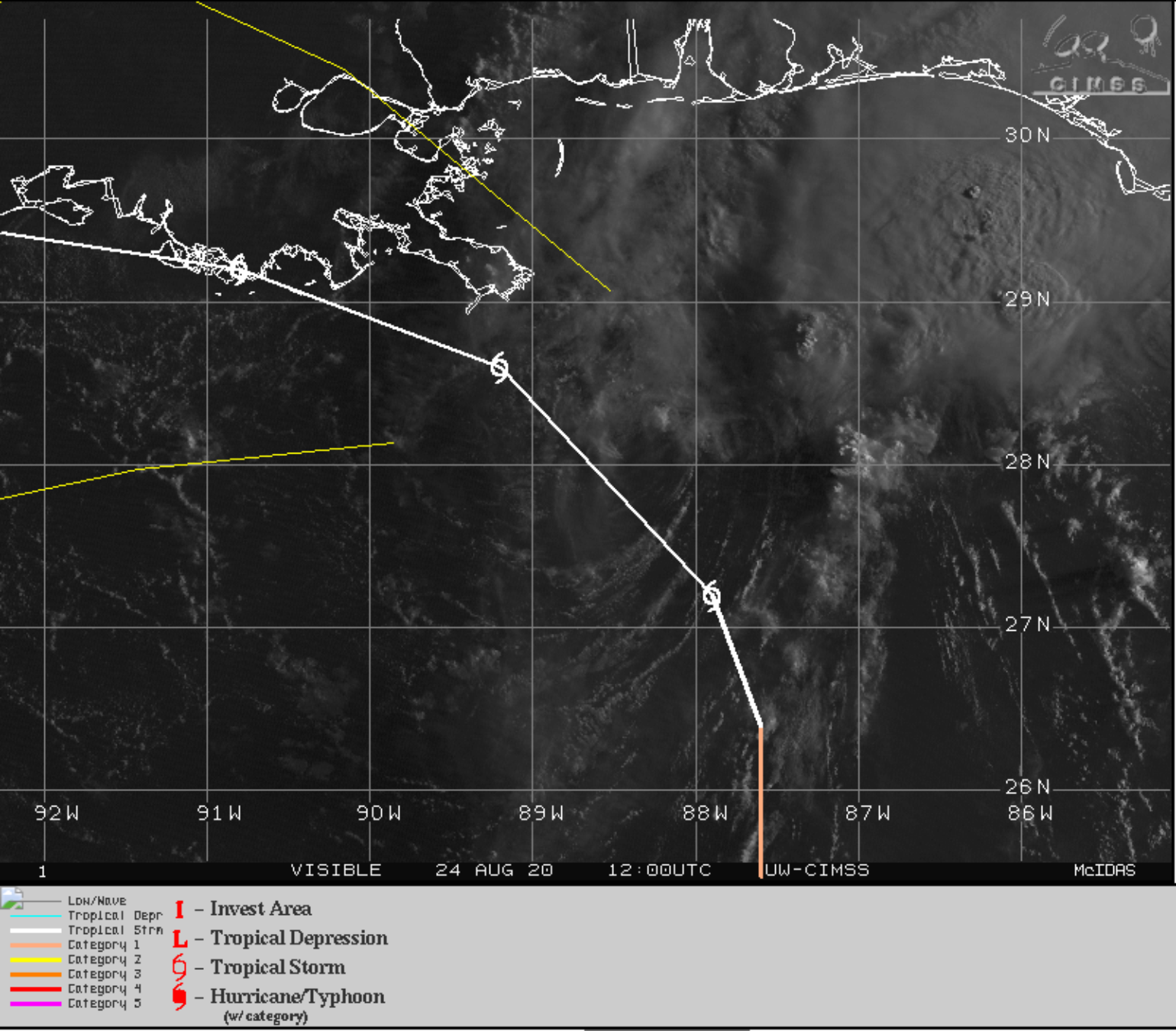
Laura still remains the biggest threat to the insurance industry, but, as these tropical updates have been saying, the forecast skill has been anything but stellar. Laura continues to track south of most of the model guidance of the last few days and is currently just off the south-central coastline of Cuba. Over the last three days, Laura has been able to maintain its general intensity while coping with the higher topographical features along its path. This overall resistance of the higher topographical features will be a bit more limited over western Cuba which should allow Laura to better organize.
Laura should have much different atmospheric conditions to deal with than Marco had as it crossed the Gulf of Mexico, which, as mentioned, had to contend with dry air and shear. Laura should be tracking into an overall better environment with low wind shear. Marco does not appear to have created much upwellings of cooler water and the fact that Laura will track right over the very warm SST of the loop current of the Gulf of Mexico is a concern for intensification. This leads many forecast models to suggest Laura will likely significantly intensify in the Gulf. In fact, the NHC is forecasting Laura to rapidly intensify.
If you have been following the model guidance for Laura over the last week there is likely a forecast that would provide any possible scenario for a Gulf Coast land falling named storm. This guidance has provided examples of a strong category 5 storm making landfall on parts of the Gulf Coast to a modest tropical storm making landfall anywhere from Brownsville, TX to Lafayette, LA. This suggests there is considerable track and intensity uncertainty with Laura. In fact, this is a good reminder that the insurance industry should not focus on the exact details of the track and intensity as issued by the NHC in the cone of uncertainty, which is not designed to show how well or poorly behaved a particular storm like Laura might be. The cone is based on the average of all forecasts from 2015 – 2019 and about 30% of the tracks stay outside of the cone at some point in a 4-5 day forecast. Laura is about 72 hours from making U.S. landfall and the track error is around 100 miles and the average intensity error is around 15 mph.
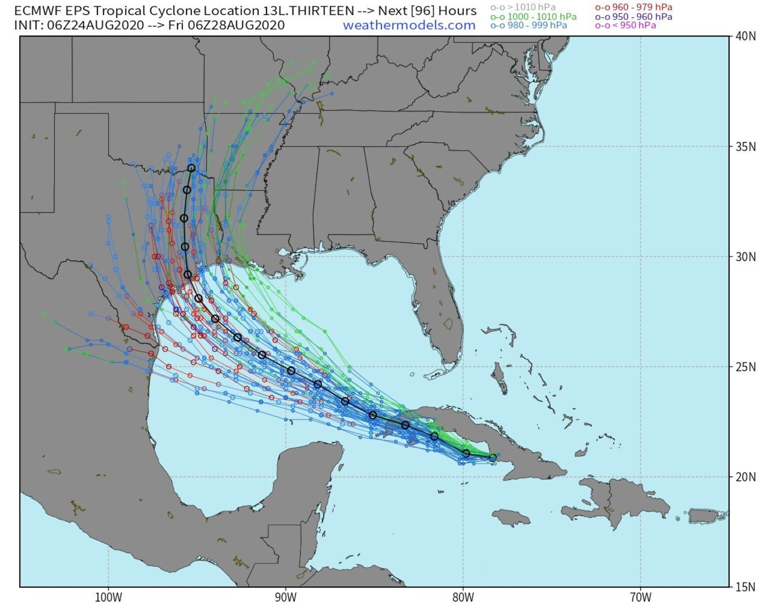
The 51 different forecasts from the ECWMF ensemble model show the forecast spread is much greater than 100 miles with landfalls possible from Brownsville, TX to Lafayette, LA. The forecast tracks that stay to the south are stronger (in red) than the track to the north (in blue/green). Most of the tracks are centered just south of Houston, TX.
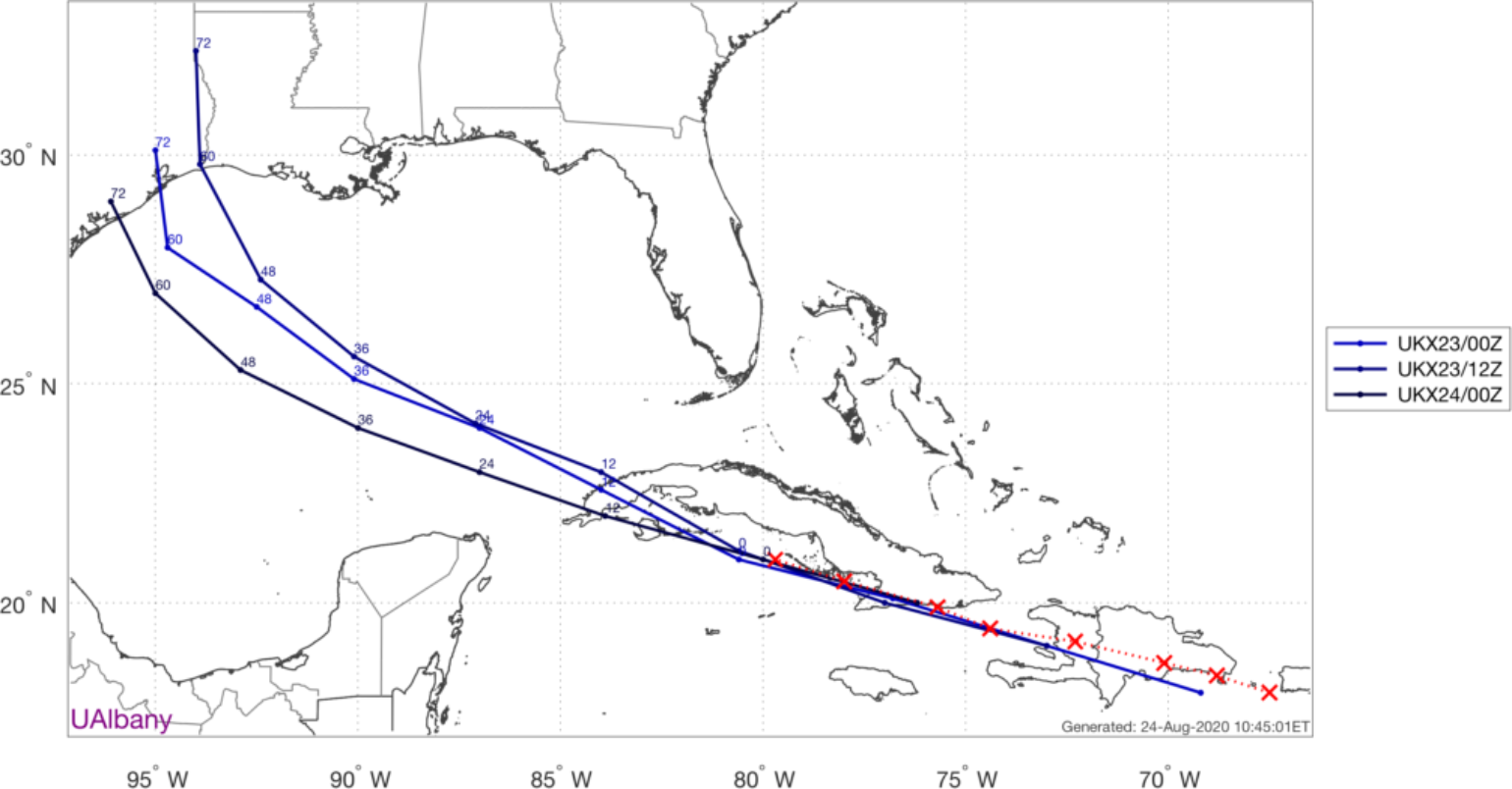
The last few runs of the ECWMF have been a bit more accurate, but the forecast model with the best skill so far appears to be the UKMet model which has significantly outperformed every other NWP model. It looks like it is even doing better than the NHC Official forecast. The trend in this model guidance is for a landfall south of Houston on Thursday as a strong category 2 or even a major hurricane. This is currently well outside of the NHC current cone of uncertainty and current intensity forecast.
In the next 24 hours after Laura gets into the Gulf of Mexico the forecast guidance on track and intensity will be better. There is a pretty clear idea that the model guidance is showing a stronger Laura and a track further southwest than what has been forecasted over the last few days, which means a weaker tropical storm with an Eastern Louisiana landfall is less likely and would not overlap with any Marco impacts.
Given the track and intensity uncertainty, it is still too early to provide detail on insurance impacts. Now that the dual hurricane threat is over I do not think there will be much to do around the issues when it comes to various named storm and hours clauses, event definitions, and deductible options. Given the weakness of Marco, it is likely that most of the insured loss, even if the two storms still track over the same general area, would come from Laura.