By Andrew Siffert – Vice President / Senior Meteorologist
There was little doubt that Hurricane Laura would become a large, powerful storm as the conditions in the Gulf of Mexico are just too perfect, as these updates have been suggesting for several days now. Laura has rapidly intensified by 55 mph in the past 24 hours (from 55 mph max winds to 110 mph max winds) at the time of this writing. This is the largest 24 hour intensification rate for an Atlantic hurricane in August since Irma on August 31st, 2017. There appears to be nothing holding Laura from becoming a mid-range Category 4 with central pressure in the 940s mb, but it probably will not get to a Category 5. The large size and time before landfall should work against this type of intensity. If Laura can make it to Category 4 status, it would join an impressive list of other August Gulf of Mexico Category 4 hurricanes that have had an impact on the insurance industry (Camille (1969), Allen (1980), Andrew (1992), Bret (1999), Charley (2004), Katrina (2005), Harvey (2017)).
The overall satellite suggests a growing and strengthening hurricane. However, the overall size that Laura is forecasted to become is likely one of the reasons why it might be limited on its maximum intensity. However, this size also means the wind field should be fairly large at landfall and would result in more inland impacts than what might happen with a smaller size storm.
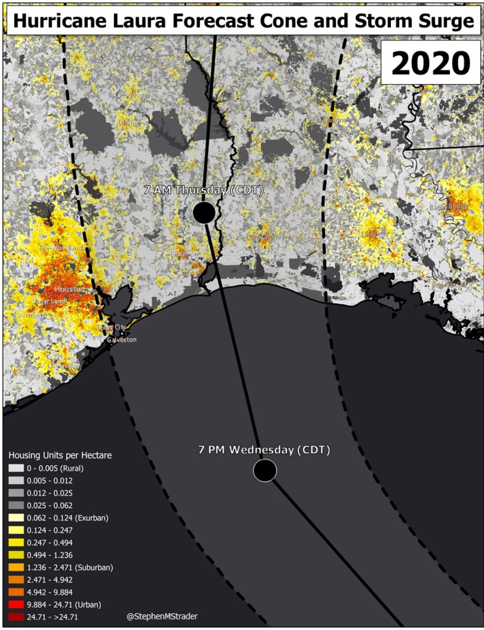
Over the last several days these tropical updates have talked about the model uncertainty as shown in the posting of various ECMWF ensemble products. Last nights ECWMF ensembles seem to shift back to the east with landfall near Cameron, Louisiana; but, overall the models are now in agreement that the overall risk to Houston is limited due to much of the insurance industry exposure being on the “Safer” west side of the storm projected path. The National Hurricane Center (NHC) has done a great job not buying into these flip-flopping models, which shows why they are some of the best forecasters in the world. The NHC is suggesting a Texas-Louisiana Border landfall.
Currently, Rita 2005 and Audrey 1957 are good analogs to understand impacts on the insurance industry. Audrey is a good comparison for storm surge, but not necessarily the level of insurance loss that is expected. Audrey should be used to benchmark the storm surge impacts as this storm still holds some of the water height records for the landfall area. Today Rita would cause about $11 billion given the overall exposure in the Golden Triangle area, but some calculations have Rita at a lower dollar value around $6 - $8 billion today, but once again the overall level of loss is noisy based on how the hazard might match up with the exposure.
Laura Wind Impacts
Provided the current forecast as of 5 AM CDT holds there is currently only a 5-10 % chance that the eastern suburbs of Houston experience hurricane-force winds and a 30-40 % chance the eastern suburbs of Houston experience tropical-storm-force winds. The biggest wind impacts will be from the Golden Triangle (Southeast Texas between the cities of Beaumont, Port Arthur, and Orange) to points just east of Lake Charles. The towns of Cameron, Creole, Hackberry, and Grand Chenier, Louisiana will take the maximum winds, provided there is no shift in the overall guidance that shows Laura making landfall in the Cameron, Louisiana area. The area of exact impact will depend on how Laura wobbles on its trajectory towards the coastline. These wobbles are common in hurricanes, and the other important aspect of landfall intensity might just be the eyewall replacement cycle. If the eyewall is strong and contracting it probably will not have much impact at landfall, but if the storm is going through an eyewall replacement cycle this could cause some weakening. These wobble and eyewall replacement cycles are difficult to predict until just hours before landfall. As mentioned yesterday, the other aspect that might cause a bit of weakening before landfall is the upwelling of slightly cooler Sea Surface Temperatures (SST) ahead of Laura which happened during Ike. However, Laura is expected to move a bit faster at landfall than Ike, so this is less likely to occur. Some model guidance is suggesting some upper-level wind shear might also pick up about 6 hours before landfall and might cause some weakening as well. However, a landfall intensity of 120-140 mph is still significant and has some uncertainty. As of 5 AM the NHC is forecasting a 1-minute wind speed of 120 mph at landfall.
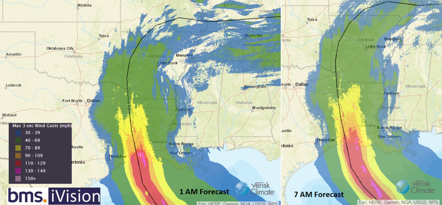
The past two forecasts of the Verisk Respond 3-second wind swath in BMS iVision (below) show the extent of the wind swath along the coast as well inland. This forecast calls for strong hurricane-force winds to extend 100 miles inland past Jasper, Texas and DeRidder, Louisiana. There is also a chance that Laura phases with the jet stream to cause some localized damage in the Tennessee River Valley area.
The insurance industry has already had plenty of experience with some stronger wind events this year. Isaias and the recent Iowa derecho both cause substantial tree fall, which was likely one of the leading causes of insurance damage from these events. The tree fall will also be a problem along the Texas-Louisiana border, and will also cause prolonged power outages to the area into next week.
Lastly, large impacts for the oil/gas industry could occur since Laura landfall is expected between Sabine Pass and Cameron which has a number of LNG plants.
Storm Surge Flooding Impacts
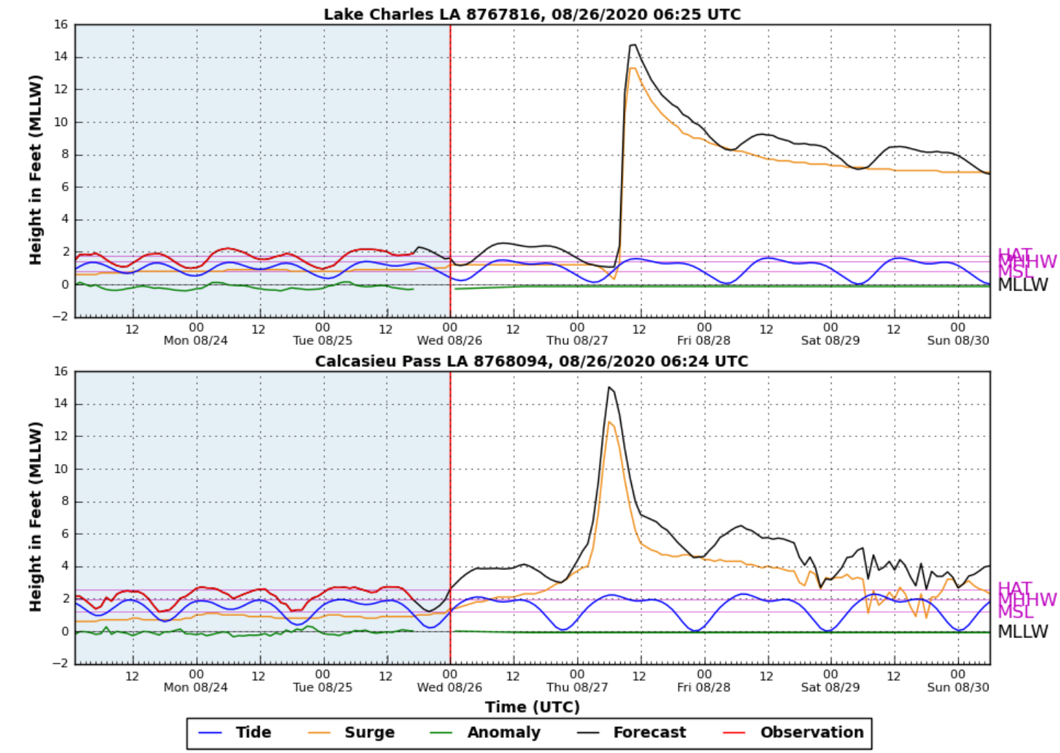
As mentioned above, Audrey 1957 holds many of the storm surge water height records in the forecasted landfall area. Storm surge and flooding are the number one cause of death from hurricanes. The northeast flank of Laura is where the storm circulation and motion will work together and pile up the Gulf of Mexico waters along the coastline. Much like the wind speeds, the worst of the storm surge will be on the ride side of the track. However, the storm surge can still spread out along the coastline. Although Galveston and the Bolivar Peninsula will be spared given the current track, the suggest areas to the east along the coastline are not so lucky. The Calcasieu Pass and Lake Charles, Louisiana water height forecasts tell the story here with a storm surge forecast of 10 plus feet at these locations.
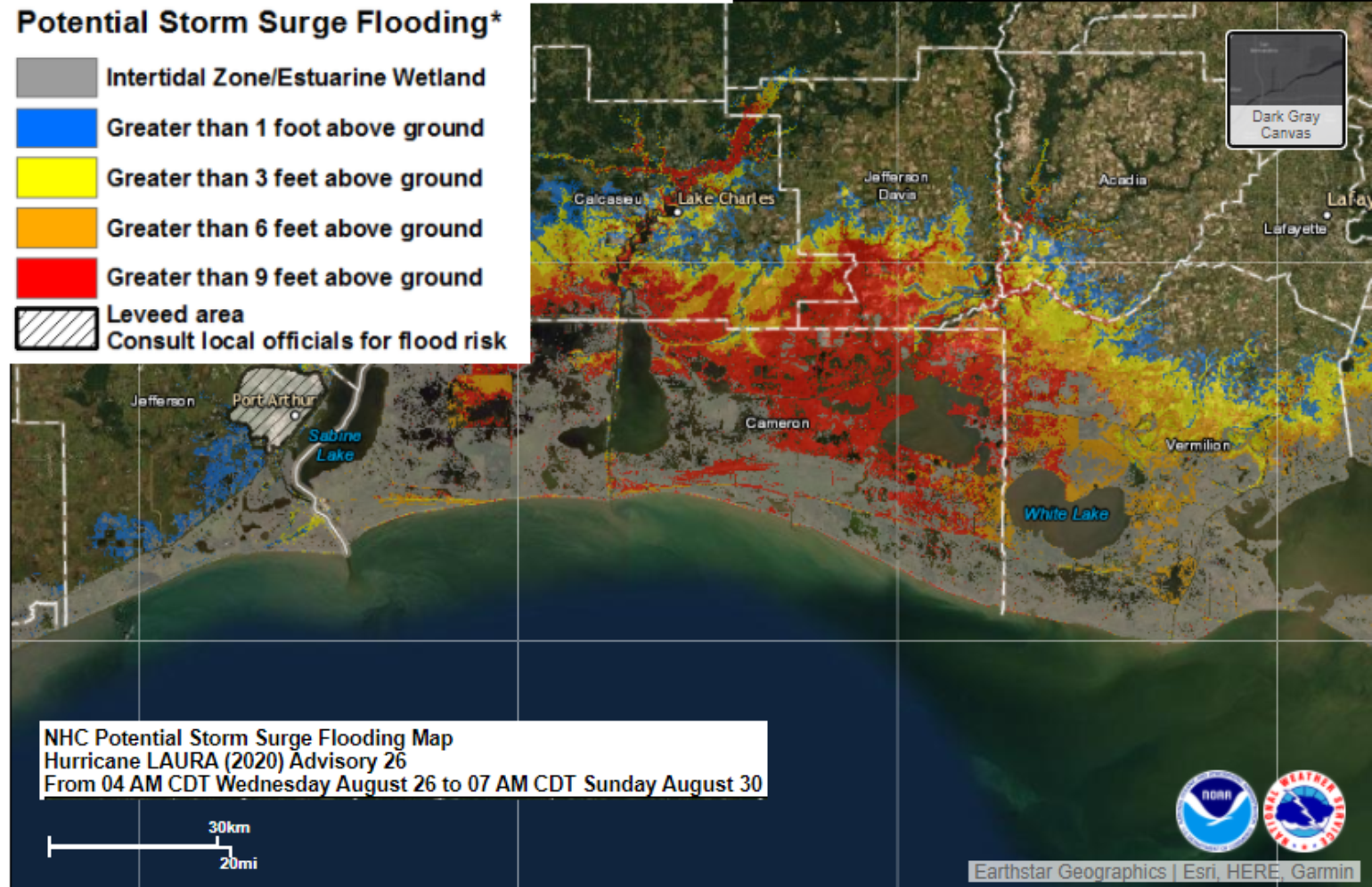
The NHC storm surge product also is very detailed and can help the insurance industry understand the height of expected water above the ground at particular risk.
The faster forward motion of Laura means rainfall will not be a heavy flooding event due to rainfall. Rainfall amounts of 4-8 inches, with areas of isolated amounts to 10 inches are expected per the NHC. This will produce a threat for flooding and flash-flooding for low lying areas along the coast, as well as areas well inland that might typically flood during heavy rain events.
Building Codes and Resiliency
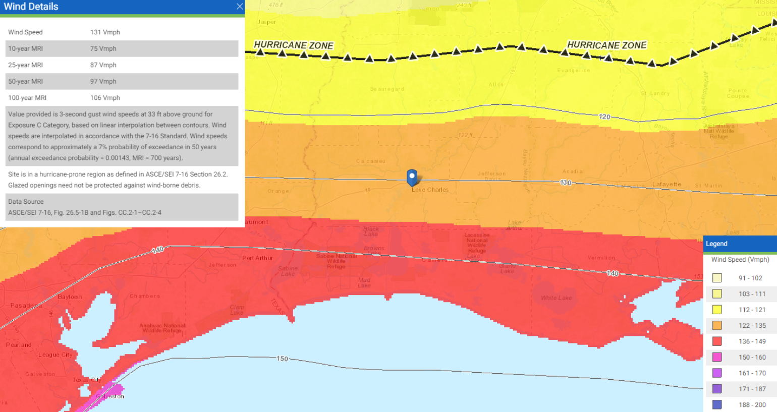
In the Insurance Institute for Business & Home Safety’s (IBHS) latest rating of the states report, which assessed elements of code enforcement and administration and contractor licensing in the 18 states most vulnerable to catastrophic hurricanes, Louisiana is one of the better coastal states for hurricanes and Texas is one of the worst. Louisiana has some on-again, off-again adaption of various design previsions, so more recently built homes might have some weakness according to the IBHS report. The American Society of Civil Engineers has a great tool to help the insurance industry understand what type of design code is expected and it shows in the Hurricane zone Laura winds are approaching the design level, which is set at 140 mph wind gusts right along the coast. Every building is different and, as mentioned, wind-blown debris, such a tress, can exacerbate overall damage. Wind-driven rain will also be a major problem for many structures in the path of Laura.
This will be an historic event, but the overall insurance industry has dodged another big loss event with a Laura track now east of the Houston area. Every wobble matters at this point along with the eyewall replacement cycle. Unfortunately, western Louisiana and areas long the Texas-Louisiana Border will take the brunt of the insurance loss. Impacts from Laura will also occur up into the Tennessee River Valley. Thankfully it looks like the insurance industry might get a break from tropical trouble for a solid week if the long-range forecast holds.