Sally is still forecasted to make landfall somewhere along the Mississippi-Alabama coastline, but the timing of landfall has slowed. Currently, landfall might not be until tomorrow afternoon or evening as Sally has slowed to a crawl. Overnight Sally has weakened with slightly lower maximum winds (85 mph) and failed to consolidate a tight inner core overnight. Provided Sally is spinning in offshore oil country, it is possible to get some good sampling of wind speeds, not only from the hurricane hunters but from oil rigs and buoys off the southeast Louisiana coastline. These observations suggest a large area of strong tropical storm force or low – end Category 1 winds. However, it is looking like the wind will not be the biggest threat associated with Sally. Extreme rainfall and storm surge flooding will be a major factor in Sally’s overall impacts.
Wind and Intensity Impacts
The other thing that is noticeable when looking at some of the buoy data near Sally is that the northern Gulf of Mexico Sea Surface Temperatures (SST) are falling rapidly in response to mixing/upwelling from Sally's winds and waves. SST are down 2-3 degrees already since this past weekend and any intro to meteorology textbook will explain warm SST are the fuel source for named storms. Since the water is cooling the overall fuel source for Sally looks to be dwindling. This does not mean Sally will just go away and dissipate but it means intensification is less likely before landfall. However, a burst of convection could lead to a stronger hurricane, maybe even a Category 2 hurricane, but this is becoming unlikely now. The other factor that is in play with Sally’s intensity is that wind shear and dry air seems to be eroding the southern side of Sally’s structure. The Cooperative Institute for Meteorological Satellite Studies at the University of Wisconsin – Madison indicates 20+ kt of shear over Sally. This is likely too high; but, it explains why Sally has failed to form a nice eye wall around its center of circulation. The key to Sally’s wind impacts might be the bursts of convection that seem to be taking place every 6 - 8 hours or so. These bursts of wrovide opportunities for intensification, which might come in distinct phases, not as one continuous development like recent hurricane Laura. Looking back at Hanna and Isaias this year they also underwent a similar evolution before their respective landfalls with a burst of convection at landfall. Overall, upwelling and shear might keep Sally’s intensity in check before landfall, but bursts of convection can provide opportunities for isolated areas of much stronger winds at the time of landfall. However, one thing is a given - these bursts of convection along with the slow movement of Sally will lead to possibly historic rainfall for the area.
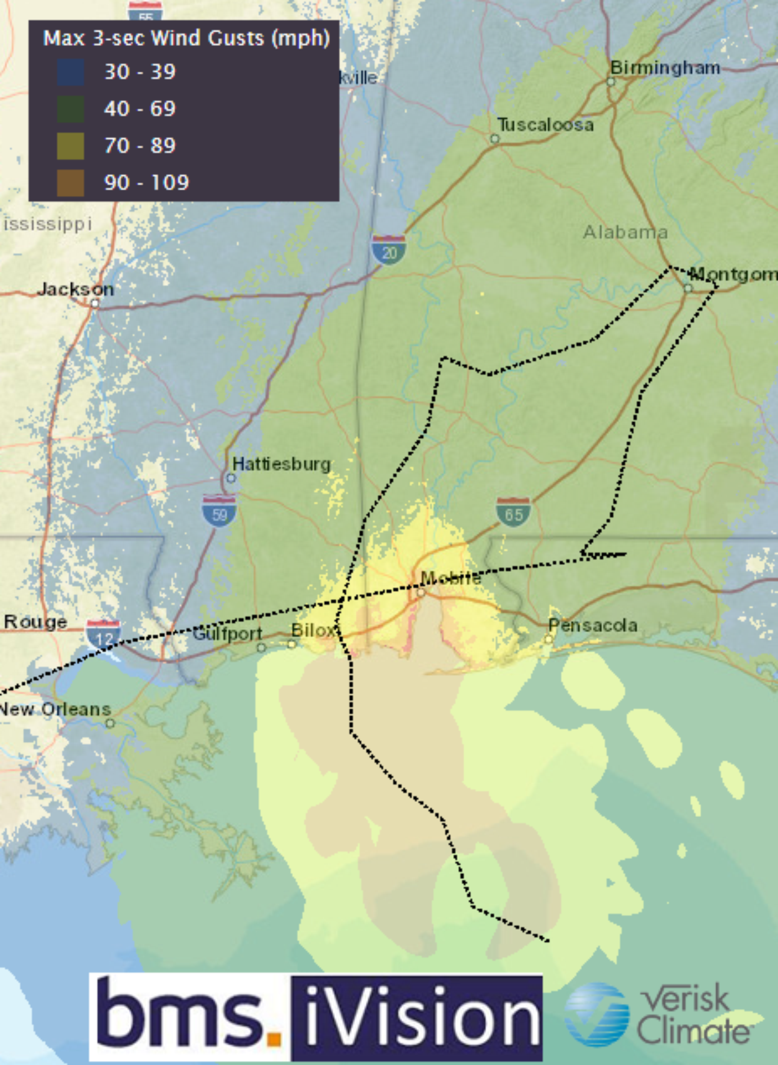
Remember the highest winds will be on the right side of the storm with the convective bursts impacting Alabama which has some of the best building codes in the country with the IBHS fortified program giving the state a high overall rating according to the IBHS.
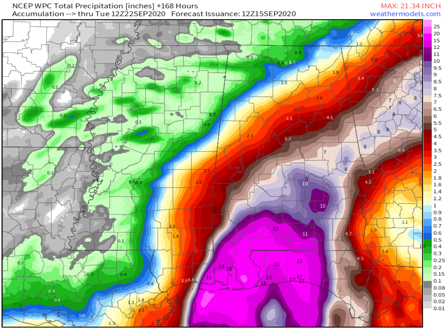
Potential for Historic Rainfall
The most rain to fall from a named storm in Mississippi was 32.21 inches from Georges (1998) and one year earlier the most rain to fall in Alabama from a named storm was 37.75 inches from Danny (1997). It will be interesting if these records hold up against Sally’s rainfall which is expected to top 25 – 30 inches of rain across coastal Alabama to northwest Florida. We will no doubt see images of water up to windows or maybe even roofs of buildings which have been common in recent slow-moving tropical systems like Baton Rouge (2016), Harvey (2017), Florence (2018), Dorian (2019). The heavy rain will not be just near the landfall areas of Mississippi and Alabama area, as it looks like areas of the Florida Panhandle could also see upwards of 12 inches of rain, as the bands from Sally produce flooding rains with some embedded tornadoes.
Storm Surge
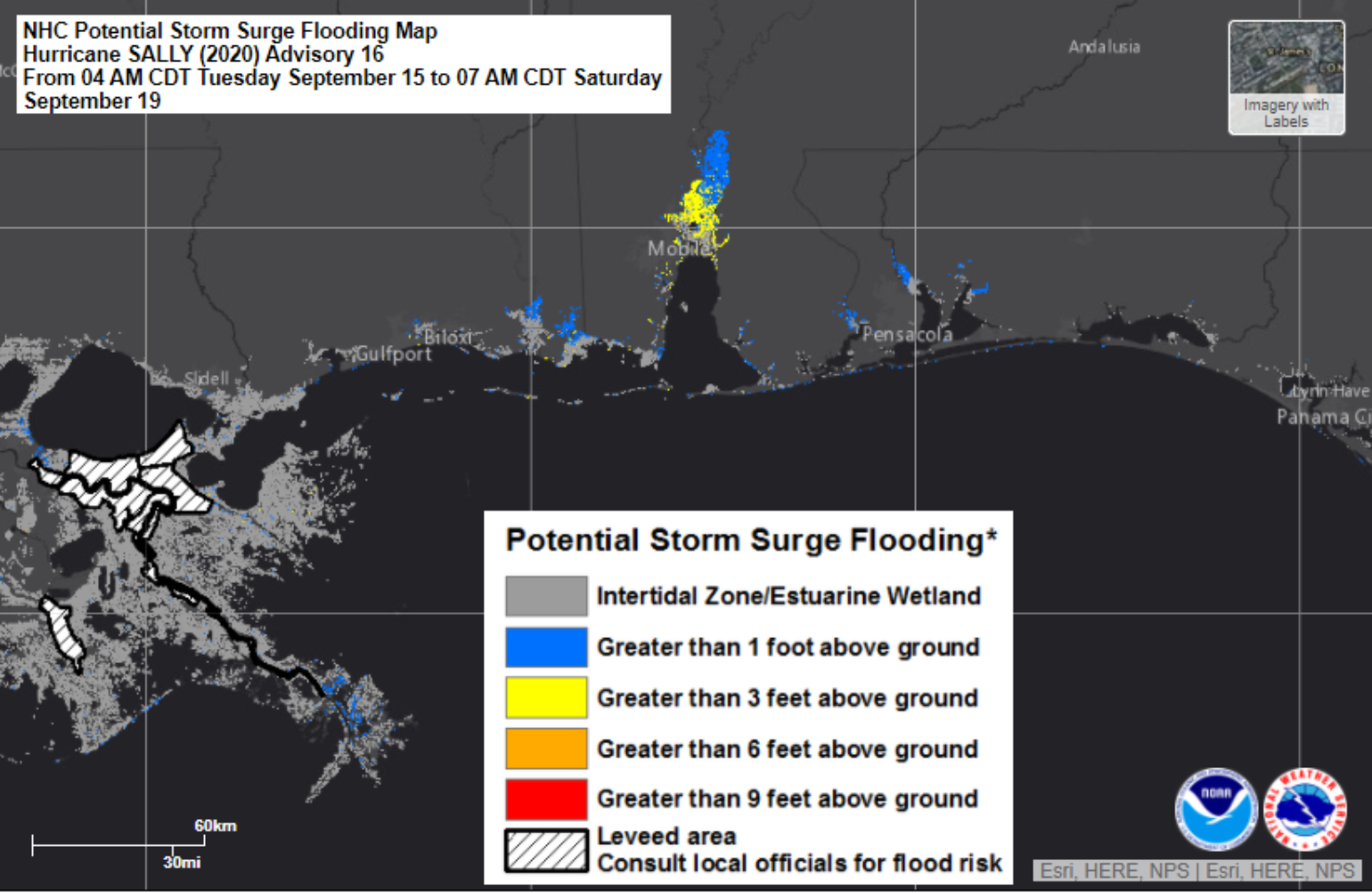
The storm surge is a tricky forecast as without a faster forward motion it provides more time for the water to move out along the coastline as Sally tracks towards the coastline. In fact, New Orleans may not even get tropical storm-force winds from Sally as the center wanders ashore to the East; but, that does not mean the area will not be impacted. Due to Sally’s slow-motion steady 25 mph northerly winds that are pushing Lake Pontchartrain towards moderate flood stage, the storm surge impacts will be felt along a large portion of the Gulf coastline. The other storm surge concern might be for Mobile Bay depending on where Sally makes landfall along the Mississippi-Alabama coastline. If Sally tracks east and makes landfall near Bloxi MS the slow forward motion inland combined with a steady south wind up Mobile Bay could pile up the water leading to higher storm surge after Sally has made landfall. Currently Mobile Bay might experience up to 6 feet of storm surge above the ground.
Overall this appears to be another named storm that will cause major flooding. Unfortunately, coastal counties have the highest National Flood Insurance Program take-up rate, which is still in the 10 – 30% range with inland counties having a take-up rate that is 1 – 5% or less. We know from the rainfall forecasts that flooding rains will occur well inland leading to loss that is likely not covered by government insurance or private insurance for many. So even though almost every year, at least since 2016, there are countless images of flooding buildings from named storms, the overall uninsured losses continue to rise exposing the overall protection gap that exists for flood coverage. However, there is also the potential to fix the problem with the right insurance coverage.
The analog provided yesterday still holds up with insurance industry losses likely falling under $800 million, which would be the same if Danny 1997 is used as an analog. Georges in 1998 was a bit more developed as a Category 2 hurricane at landfall that was slow-moving and resulted in a much higher insurance industry loss of around $1.8 billion today.