Incredibly, Hurricane Sally's intensity leaped just before landfall at 5 AM CDT and hit as Category 2 with 105 mph winds near Gulf Shores, Alabama. Hurricane Center warns "catastrophic flooding" likely with 20 or more inches of rain already being reported. Over 500,000 people are already without power. What is maybe more incredible is Sally is making landfall in roughly the same area Hurricane Ivan made landfall 16 years ago to the same day.
After two days spinning less than 150 miles off the coast of Alabama, Florida, and Mississippi, Hurricane Sally finally made its move to come ashore Tuesday night. To many people’s surprise, it intensified as it came ashore. There were a few models that supported this intensity, but overwhelmingly most models and even the Hurricane Center did not predict this intensity even 12 hours ago. This is just yet another case that shows the forecasting of intensity has a long way to go compared to forecasting the track of named storms. The other interesting aspect is that typically Gulf coast hurricanes have historically weakened before landfall, but Laura and now Sally have made a mockery of this idea that Gulf of Mexico hurricanes will weaken before landfall.
Although the storm’s slow forward speed was well forecasted the increase in intensity from an 85 mph hurricane at landfall to a 105 mph hurricane will make a large difference in insurance losses, especially when you start to weigh in the overall duration of these winds on structures. This will likely be yet another billion-dollar insurance industry loss event considering the higher exposure of Pensacola that is impacted by Sally’s perils.
Wind Impacts
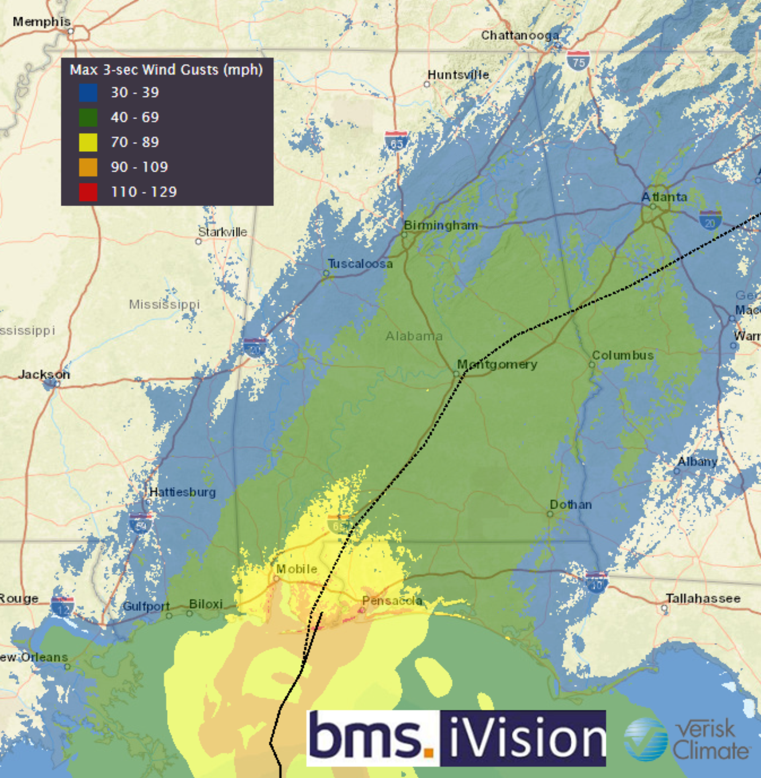
Below is the latest BMS iVision Verisk Respond product BMS clients have access to that provides a data layer for clients to understand the duration of winds gusts of 50+ mph. Constant winds like these can put a strain on building components like roof and siding, and furthermore can lead to higher loss than if it was just a normal quick 3-second wind gust. This will be an important factor in understanding the overall loss impacts from Sally.
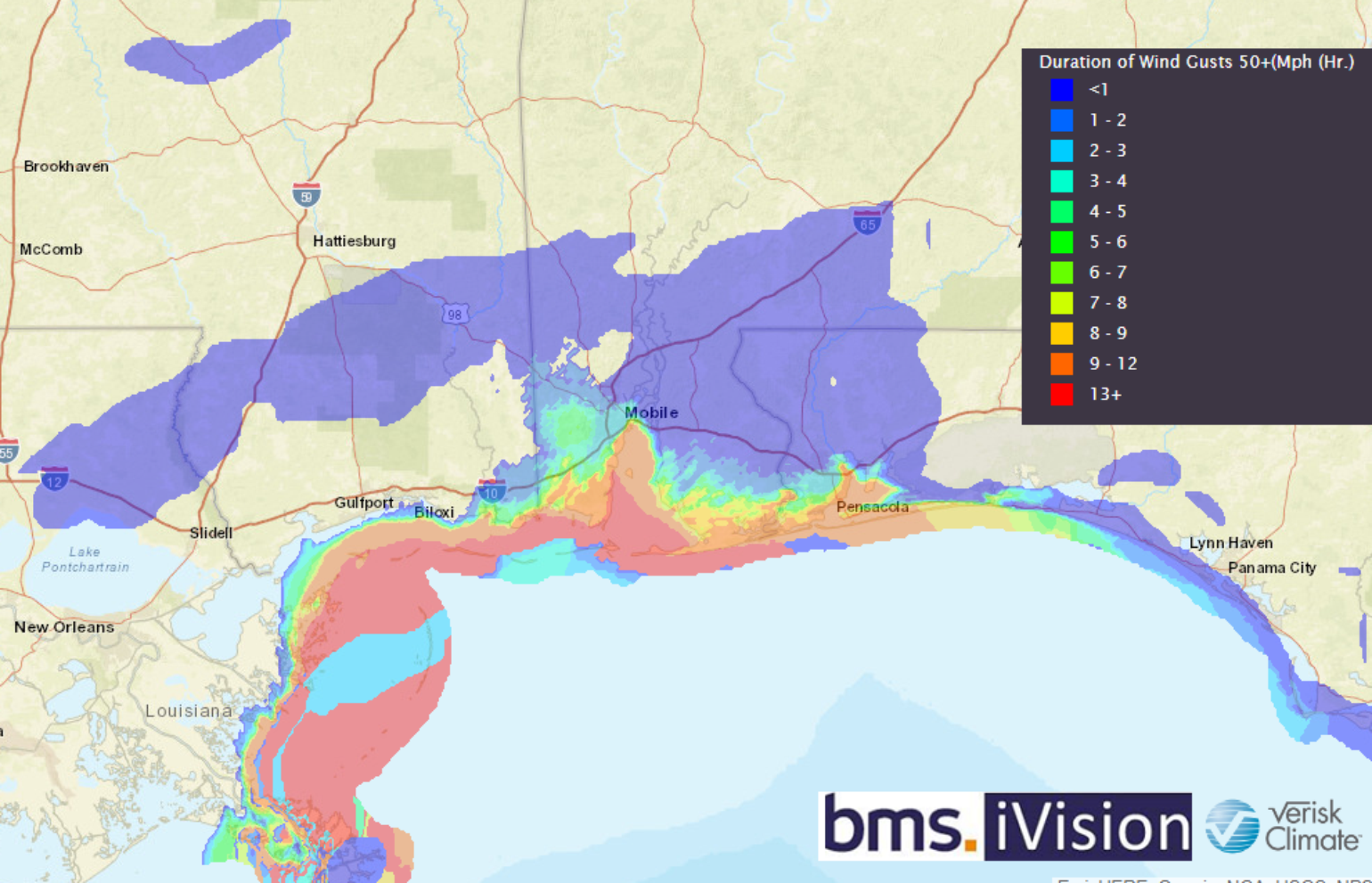
The overall strength of the wind is still important as Sally came ashore in Gulf Shores, Alabama. This landfall location puts the more populated area of Pensacola right along the outer eyewall of Sally's strongest winds. A 93 mph wind gust was measured at the Naval Air Station in Pensacola. Dauphin Island, Florida also reported a 99 mph wind gust, which is 44 feet above ground level.
The same area was impacted by Category 3 Ivan 16 years ago, and the general construction across the Panhandle remains wood frame. According to Hank Hodde the Sustainability & Resilience Coordinator for Pinellas County, Florida the good news is coastal cities such as Orange Beach and Gulf Shores have implemented both Insurance Institute for Business & Home Safety (IBHS) Fortified Homes and high freeboard into their building codes in recent years; therefore, after Ivan, Sally is a good test of these resiliency efforts. However, the vast majority of the building stock is not resilient and many buildings are not built to code, which might be fine for a Category 2 wind gust. The general idea is storms will keep happening and the IBHS has shown time and time again that the return on investment with building a stronger safer structure is the right way to manage hurricane risk and Sally and Ivan will not be the last storms to impact this area.
Storm Surge Impacts
With the slight shift in track to the east side of Mobile Bay, the overall storm surge threat has also shifted East to Pensacola; however, as mentioned in the BMS Tropical Update yesterday, the overall slow forward motion will allow the storm surge to spread out along the coastline. Unlike Ivan that was a category 3, 120 mph hurricane at landfall, the storm surge should be well under the maximum storm surge of 14 feet that was observed from Hurricane Ivan. Sally is expected to bring only 4-6 feet of storm surge to the inland portions of Escambia Bay and Blackwater Bay. Meanwhile, west of Sally’s center, strong northerly (offshore) winds are pushing water away from the coast. Mobile Bay is draining and the water levels are now five feet below normal and falling.
Rainfall Impacts
As mentioned over the last several days, one of the biggest impacts due to its slow forward motion will be the rainfall. So far this morning there has been 24.80 inches of rainfall just west of NAS Pensacola and it will likely rain for the next several hours. In fact, this makes me think back to the devastating flooding that occurred in the Pensacola area in April 2014, which resulted in big improvements to the stormwater system. The following is a great article on why not only personal and commercial insureds should be thinking about resiliency but cities too. The work that was done after 2014 will hopefully pay dividends with Sally and result in a much lower level of flood loss. However, we cannot be fooled, any rainfall over 20 inches will likely lead to major flooding problems and social media is already showing flooded homes and business.

Use of Social Media in Sally
As mentioned in my final Laura update to the insurance industry, now is a great time to use social media in catastrophe response to get a good read on the overall damage. This has been particularly important for insurance companies in the time of COVID-19. The general idea of using social media is to also look beyond the main focal point of what is being shown. Look at other buildings and trees in the background, as a lot of information can be taken from this type of content.
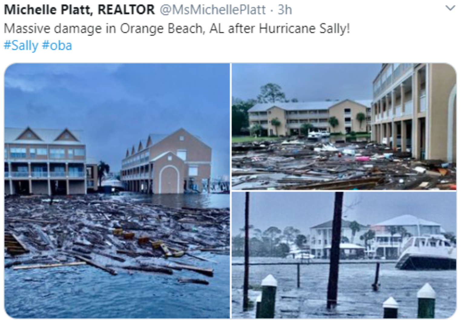
In this example, the tweet reads “Massive damage” in Orange Beach, Florida, but really if you look beyond the lumber, which is maybe from docks in the harbor, the overall buildings look to be in good shape here and are elevated. The windows look to be intact and the roof covering looks to be in place. So take a look beyond the headline and the focal point. Use social media to get a wider understanding of damage, which can help claims adjusting staff, restoration companies, and tarping services to be deployed to the right area faster.
What Is Next?
Do you know every hurricane that has formed in the Atlantic this year has hit land? Sally is the 4th landfalling hurricane this year. (Hanna, Isaias, Laura). Just this week Paulette was a hurricane and hit Bermuda, which is amazing by itself. The most recent year with four U.S. landfalling hurricanes is 2005 with 5 landfalls. According to my records, the season with the most hurricane U.S. landfalls was six so 2020 still has a shot at that record. It is interesting that after the 2005 hurricane season the U.S. coastline went into a drought of hurricane landfalls and had the longest period ever recorded between major hurricane landfalls. In the insurance industry landfalls are what matters. When you look at the overall distribution of landfalls in the U.S. since 2017, there has been a major correction to the overall mean rate of expected landfalls over the long term.
Will the U.S see another landfalling named storm this season? At this point, it looks highly possible given the date on the calendar. Often October tends to be a period when named storms like to form in the Gulf of Mexico or the Western Caribbean and track north. However, in the near term, Hurricane Teddy is a classic example of hurricane clustering and is following in the path of Paulette and could impact Bermuda. As if Sally and Paulette were not enough. The latest run of the ECMWF model shows a trough of low pressure grabbing Teddy and turning it NW into Maine or Nova Scotia later next week. This is similar to Sandy except further north. This needs to be watched closely for New England and Atlantic Canada impacts. So clearly Teddy “Bears” watching!