By Andrew Siffert – Vice President / Senior Meteorologist
If you are not aware, the 2020 hurricane season has now run out of names, and the fall back for the National Hurricane Center (NHC) is to start using names from the Greek Alphabet. In 2005, Atlantic named storms reached the name Zeta, so thirty-one storms in total. In this active 2020 season, we are at named storm Delta - so 26 named storms. With a few other systems also being watched by NHC in the Atlantic Ocean, there is a good chance that the list of active named storms will sound like a fraternity or sorority row on a college campus.
I was debating if I should copy and paste the tropical update from August 20th that talked about Tropical Storm Marco and what would be Hurricane Laura entering the Gulf of Mexico at the same time. This is precisely what is going on this morning. Currently, Tropical Storm Gamma, the third letter in the Greek Alphabet, is offshore of the northern Yucatan Peninsula in the southern Gulf of Mexico and is expected to weaken in the coming days. In fact, this morning, it appears that the deep convection is decoupled from the center of circulation as strong southerly vertical wind shear impacts the storm. Still, Gamma will play an essential role in setting up the environmental conditions in the Gulf of Mexico for Delta, which is currently in the Western Caribbean about 135 miles south of Negril, Jamaica.
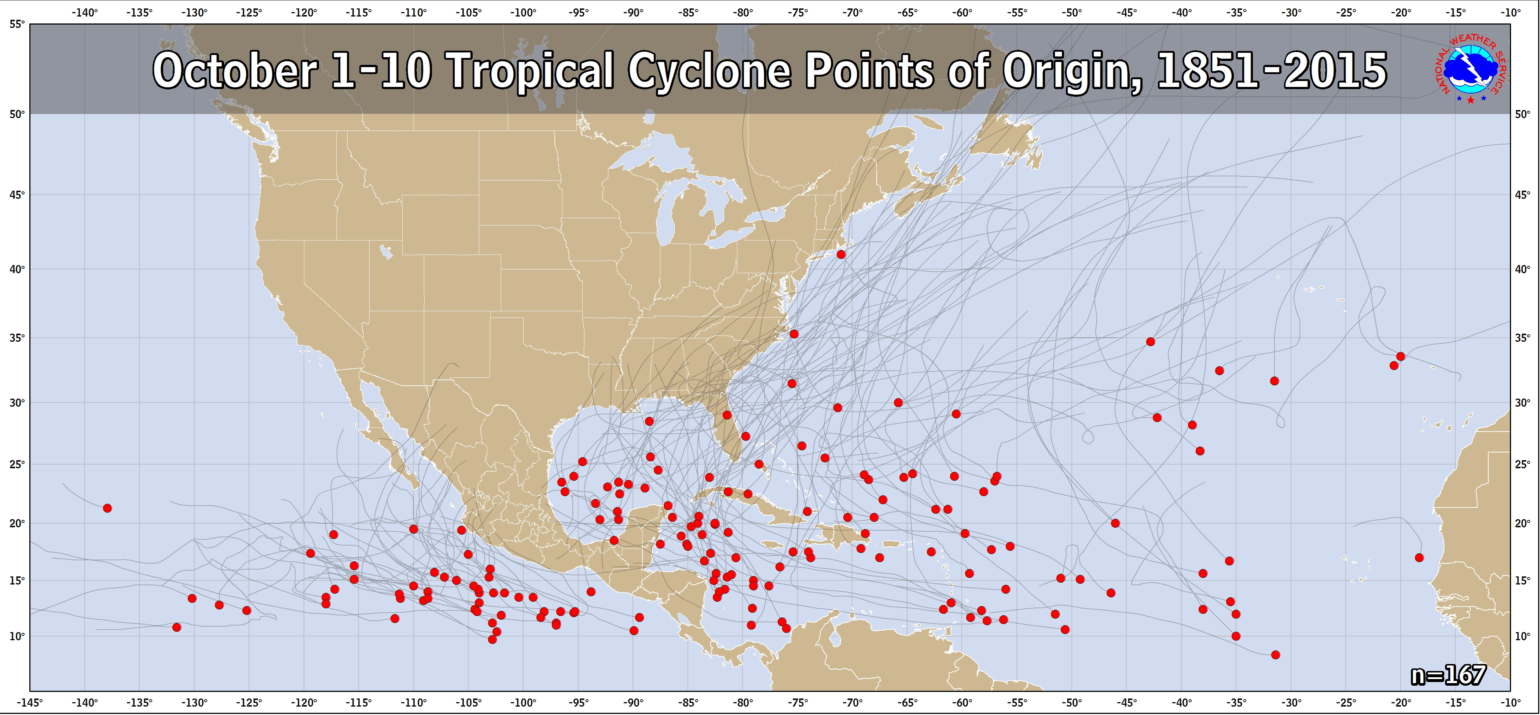
Both Gamma and Delta have formed in a region typical of October storms in the Atlantic basin. In October, storm formation migrates away from the Cape Verde region of the eastern Atlantic to the western Caribbean Sea, west Atlantic Ocean, and the Gulf of Mexico where waters are still very warm and wind shear low, both of which are critical in named storm formation.
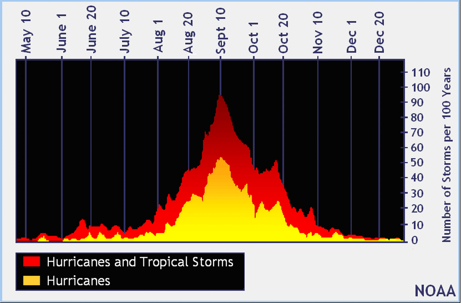
Though we have surpassed the “peak” of the season, the graphic below illustrates plenty of potential tropical activity ahead of us. There are even tiny peaks in mid and late October, which might go along with this new activity that will occur in the Atlantic basin this week.
With Tropical Storm Gamma decoupled from its low-level center, the convection is moving to the northeast, which should result in some drastic weakening of Gamma, but will be relevant to Delta’s forecast. Gamma might prime the atmosphere with moisture as Delta becomes the more dominant system taking advantage of more favorable conditions in the Northwest Caribbean over the next few days. Because of this, anything left of Gamma should be absorbed into Delta in the next 3 – 4 days. Since Delta will be the dominant structure, the obvious question is what will happen over the next 3- 4 days as it tracks toward the Northern Gulf of Mexico.
Part of the complicated forecast for Delta has to do with a pattern change in store for much of North America. As you might have read in my fall wildfire update, some short-term relief comes with a slight pattern change to Northern California. This pattern change will surely help with the fires over Northern Californa with cooler temperatures, and widespread precipitation possible across the area. This same pattern change will force Delta to turn more northerly towards the central Gulf of Mexico coastline. This should result in Delta moving fairly rapidly at landfall, which was not the case with slower-moving Hurricane Laura or Sally earlier this year.
As these tropical updates have pointed out, one of the more essential fuels for hurricane development is weak wind shear and warm Sea Surface Temperatures (SST). Delta should have, along its forecasted track, some of the Atlantic Ocean's warmest waters, which are about 86 degrees Fahrenheit.
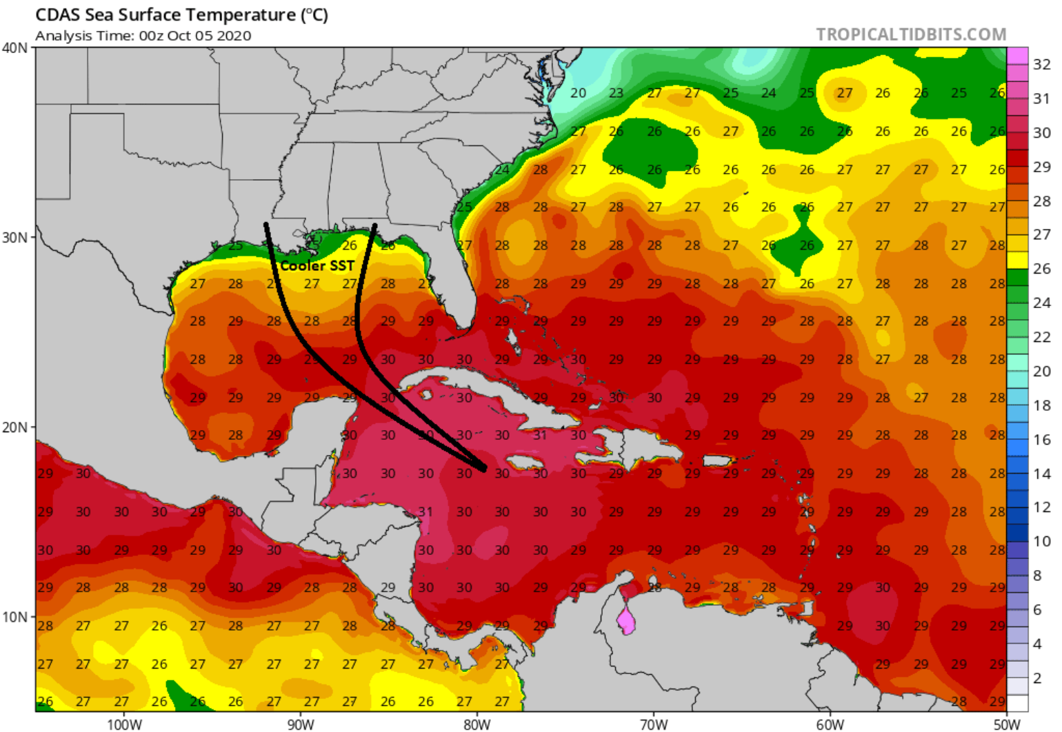
With lower wind shear over the next few days, the warm SST Delta is expected to strengthen into a solid Category 2 or 3 hurricane over the next 72 hours. If there is a bit of good news, the SST along the Northern Gulf Coast is much cooler (78 degrees Fahrenheit) than those for Laura and Sally landfalls. The complicating fact here is that Delta will be moving faster, leaving less time to weaken over colder water so this cooler water might not have as much impact at landfall. A lot can change with the forecast over the next 96 hours as landfall is forecasted sometime on Friday this week. How fast and exactly how much wind shear will be present in the Northern Gulf of Mexico will all be key to the overall intensity of Delta at landfall. Still, regardless another possible landfalling hurricane will occur later this week along the Gulf Coast of the U.S., which would be the 10th tropical storm to strike the U.S. coastline this season. This would break the record for the most landfalling tropical cyclones in a season, currently 9 set in 1916. And once the final track maps are produced for the 2020 season, it is clear that the central Gulf of Mexico coastline will look like what Florida looked like in 2004 once again as a great example of track clustering with multiple impacts in the same general area.
More tropical updates will be posted this week as Delta becomes the main story for the insurance industry. Better analog storms become available as we get a read on the overall intensity and speed at landfall, allowing for a better understanding of coastal and inland impacts.