By Andrew Siffert – Vice President / Senior Meteorologist
Hurricane Delta is moving through the Gulf of Mexico this morning and slowly intensifying. While Delta is struggling to become a well-organized hurricane, the light wind shear and warm water should allow Delta to become a weaker Category 3 hurricane before landfall. As discussed in the past few tropical updates, Delta would grow in size after crossing the Yucatan Pensizulsa. The satellite data and hurricane hunter aircraft's observational data show the overall footprint has expanded significantly over the last 24 hours. This will make rapid intensification harder to pull off, leaving a wider swath of the coastline to experience strong winds, and a considerably larger storm surge footprint.
Delta should start its turn towards the north today with the various forecast models in excellent agreement about the storm's general track. The only question is how fast Delta will be moving over the next 24 hours, with the most likely scenario suggesting landfall will be around midday tomorrow.
Over the last several days, the tropical updates have been using Lili 2002 as an example of what might happen to Delta right before landfall as cooler Sea Surface Temperature (SST) and stronger wind shear from a trough of low pressure moves over Texas. It seems like this trough is a bit weaker, which could weaken wind shear impacts before landfall. Given Delta will be tracking at close to 15 - 20 mph, it will only have 6 – 8 hours to downgrade from a low-end Category 3 / high-end Category 2 hurricane to a low-end Category 2 / Category 1 hurricane.
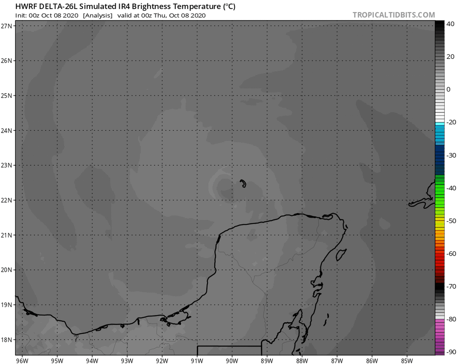
Below is an animation of the simulated infrared satellite from the HWRF model showing Delta developing a nice eye feature later today, but right before landfall, that eye feature collapses, and the deep convection gets shear, exposing the surface low of Delta as dry air and shear weaken the storm rapidly.
Landfall Wind Impacts
Delta’s weakening does not mean it won't significantly impact the insurance industry. High winds will also be of concern near where Delta makes landfall. With Delta's maximum sustained winds during landfall forecasted to be around 90 -105 mph, the damage will occur to the areas already hit hard from hurricane Laura six weeks ago. Sometimes, when hurricanes weaken from wind shear, the wind field can expand from the storm's center. If this occurs with Delta, the number of insured locations that will experience tropical-storm-force winds could be greater. The other factor to consider here is the storm's fast forward motion, allowing strong winds to move farther inland than would normally be expected. Even properties 100-150 miles north/northeast of the landfall point could experience strong winds and power outages.
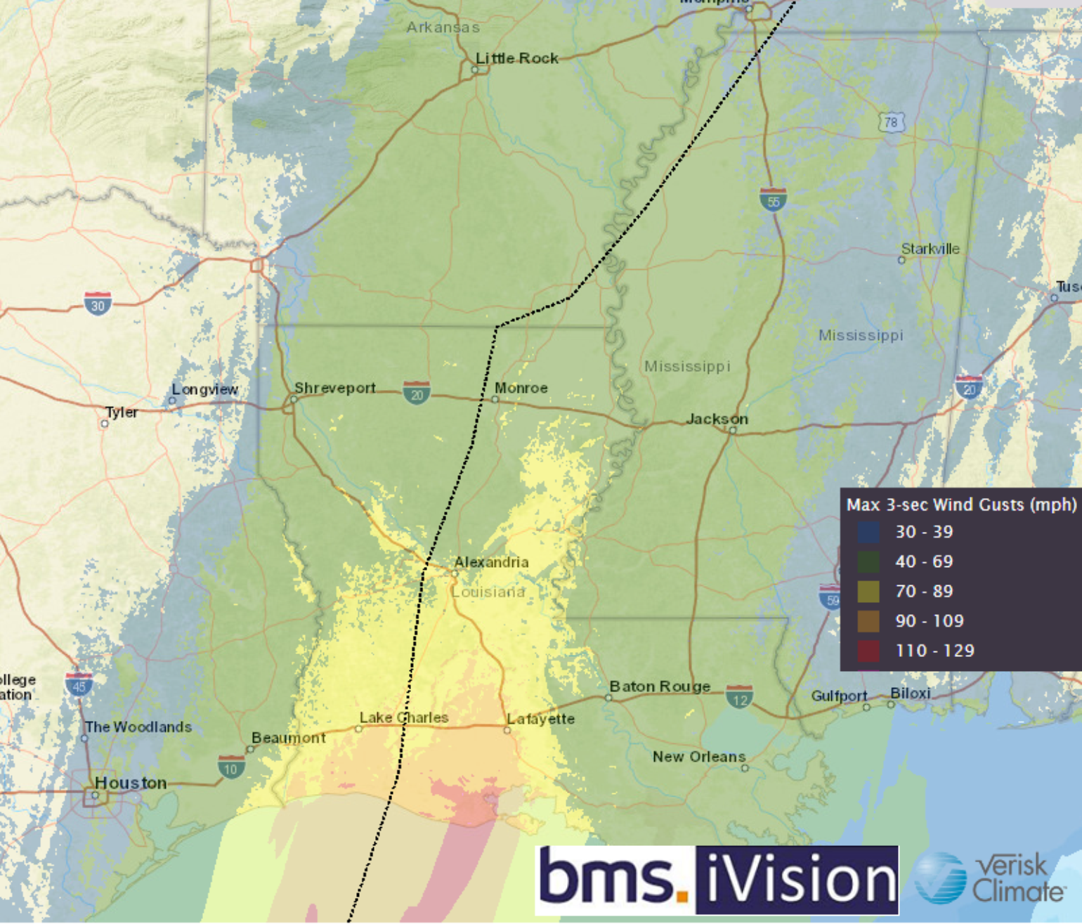
BMS iVision, along with the Verisk Respond product (shown below) is an excellent tool for the insurance industry to understand wind impacts from Hurricane Delta. As always, the strongest winds will be on the right side of the storm, potentially bringing 80 – 100 mph winds into Lafayette, LA. This area, for the most part, was spared the strongest winds from Hurricane Laura. Complicating the wind impacts even more with Delta, is that they will blow in different directions and at different intensities than Hurricane Laura, so a tree that might have been weakened by Hurricane Laura might come down on a structure from Hurricane Delta.
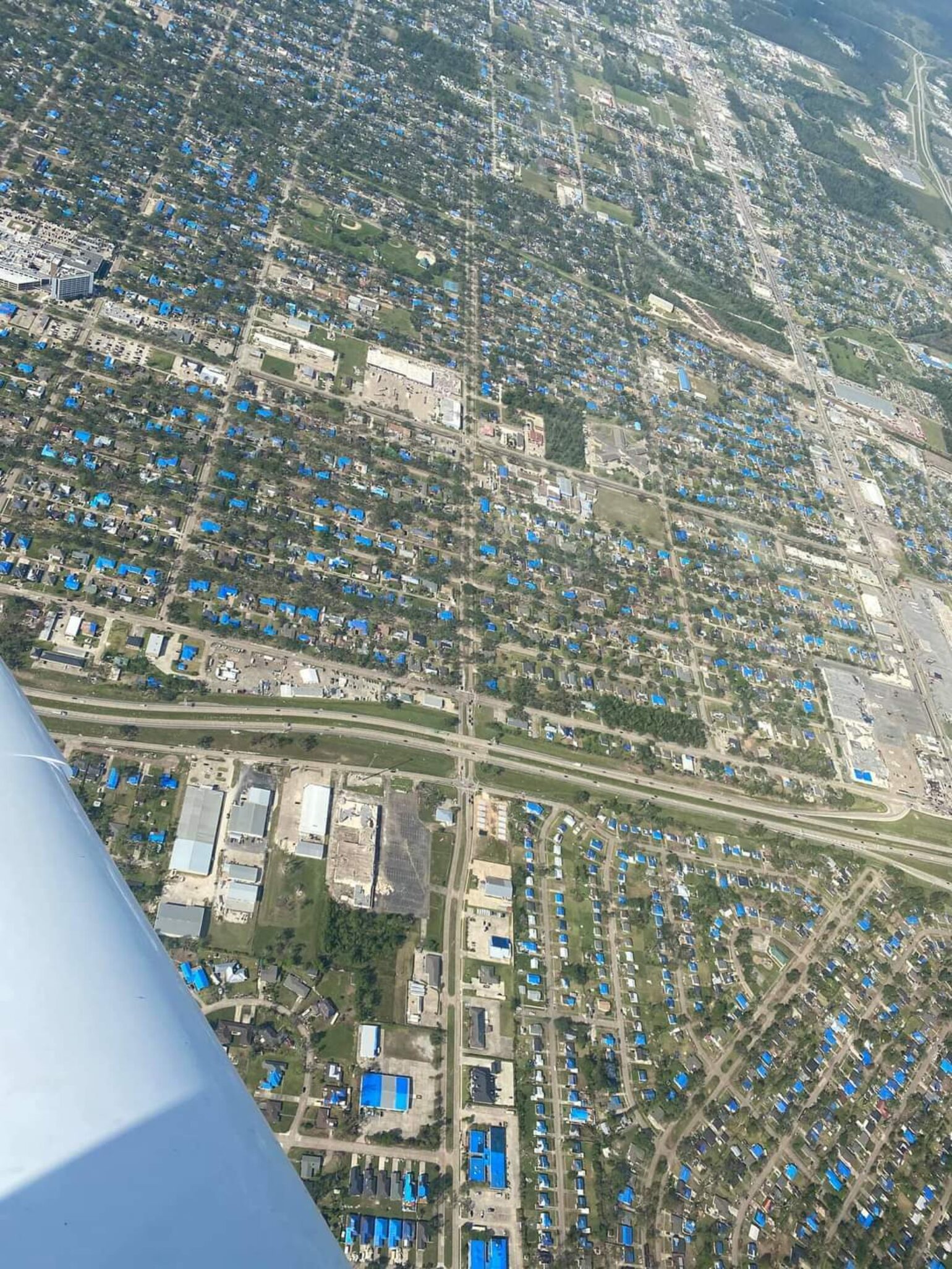
Regardless, it is pretty surreal to see another significant hurricane impacting the same area of Southwest Louisiana so soon after Laura. However, this is not without precedent. The 2004 season in Florida featured three hurricanes all passing through similar parts of the state. Just like in 2004, insurance claims could become more complex, especially since many of the areas in Lake Charles, LA, are still recovering from the damages of Laura, with many of the roofs in the area still covered with tarps, which will not hold up well against the winds of Delta.
Rainfall Impacts
Because so many locations are tarped, they remain vulnerable to rainfall. Delta's fast movement is not all bad news in this case. With the storm not lingering in any given location for very long, the rain threat should be manageable. The current forecast calls for roughly 4-8″ of rain along and just west of Delta's track. This will undoubtedly cause flash flooding issues in spots, but we shouldn't see much, if any, significant/widespread flooding like we saw with Sally or other slow-moving storms this season. However, this amount of rain will indeed cause significant issues and further damage if it bypasses the tarped roofs and gets into the buildings.
Storm Surge Impacts
As we saw with Hurricane Laura, the Louisiana coastline is very susceptible to storm surge. Given Delta’s size and strength, this creates a more significant concern for storm surge with its landfall location. Any storm surge that occurs will likely be similar to Hurricane Laura, which caused storm surge damage, so the damage to the building form storm surge has likely already occurred. Laura's 17-foot storm surge moved through Cameron Parish which is relatively rural with few structures. The NHC's inundation forecast calls for parts of coastal Louisiana southeast of Lafayette to be under 9+ feet of water sometime Friday evening. The surge will cause some issues as far west as Beaumont/Port Arthur and as far east as coastal Mississippi.
Catastrophe Modeling Complications
As highlighted, the claims process could be further complicated by Hurricane Delta, making landfall just six weeks after Hurricane Laura in the same general area. The insurance industry experienced several complications in 2004 when this occurred, and history is repeating itself. The other thing to consider is that although the track could be slightly different, damage to structures has already happened in the area. When using catastrophe models, they generally don't factor this in, so any damage estimates from the model need to be taken with a greater degree of uncertainty. The catastrophe model does not explicitly account for the current degree of damage that might have already occurred to a roof that has already been a paid claim, possibly overstating the loss estimate from the catastrophe model. The model also does not generally account for the fact that the roof might already be weakened and could increase damage from wind and rain. This leaves something to think about as the insurance industry starts to release industry loss estimates, which will surely be larger than the normal range provided the uncertainty in how much Delta might weaken before landfall.