By Andrew Siffert – Vice President / Senior Meteorologist
Because it is a busy renewal season and Zeta’s fast forward motion is so critical to the impacts to the insurance industry, another Vlog has been posted that goes into more detail on the impacts that are highlighted below.
In yesterday's update and video, I outlined how Zeta was expected to modestly strengthen as it moved through the Gulf of Mexico, supported by a moist atmosphere and low wind shear environment. It was pointed out that the colder waters to the north near the Gulf Coast would not allow for much weakening due to the fast forward motion Zeta will have as it races towards landfall. Zeta now has the potential to become a Category 2 before landfall, which is stronger than yesterday's forecast model guidance. Little weakening is expected to occur right before landfall. Once again, the insurance industry cannot discount Zeta provided how close it will track to New Orleans, which will significantly depend on how the wind field takes shape over the metro area of 1.2 million people. Depending on the track proximity to the metro area, it could easily cause significant loss to the insurance industry.
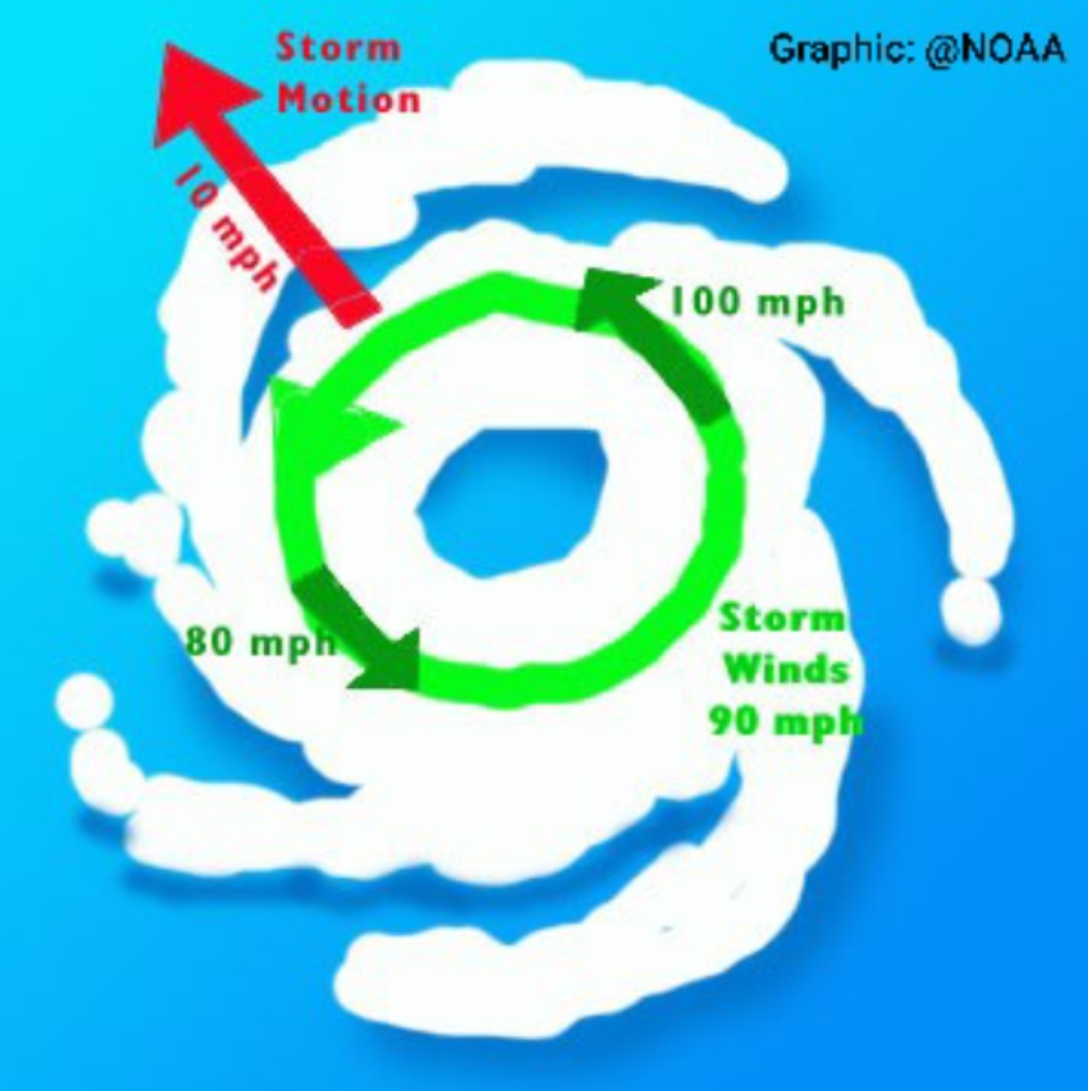
This morning's satellite imagery shows a marked increase in convection compared to 24 hours ago as the storm moved off the Yucatan. A more well-defined eye is taking shape, which points to a healthy and strengthening hurricane. The observation from the hurricane hunter aircraft offers some valuable insight into the storm's wind field. Given Zeta is tracking at 18 mph to the north, 220 miles southwest of the mouth of the Mississippi River, it is clear that the strongest winds are focused east of the center. This is where the storm’s motion vector adds to the circulation winds. This will be a very critical aspect to Zeta's impact on risks along the Gulf Coast. The faster the storm motion, the higher the potential winds on the side where winds follow the forward motion and weaker winds on the opposite side. Therefore, at landfall, the risks to the east of Zeta's center will have the highest damage degrees.
The Sea Surface Temperatures (SST) do not get colder (below 78 degrees F) until the last 50 miles before Louisiana. Provided the fast forward motion, it will not have much time over these cooler waters. When you combine this with Zeta getting caught up with favorable jet stream dynamics due to the upper-level trough of low pressure that created the ice storm over the southern plains, Zeta should maintain its strengthening with little weakening before landfall.
The Right Side of the Track
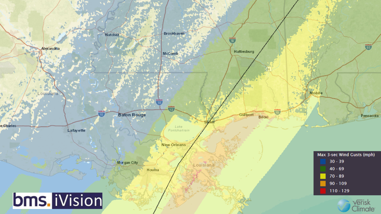
The BMS iVision Verisk 3-second wind gust respond product provides a good look at how Zeta's wind field will look as it moves ashore. The forecast below, which is updated four times daily, allows BMS clients to get multiple views of potential impacts to a portfolio of risks. The latest forecast shows that the strongest winds will be focused just east of the storm center's track. This means that New Orleans metro area is just to the east of the strongest winds, which is critical in the ultimate loss; however, places along the Mississippi coastline 30-50 miles east of the center will see significantly stronger winds than parts of Louisiana 10-15 miles west of the center.
It would appear that the storm surge will not be significant due to the storm's fast forward motion. Still, the wind direction at landfall will funnel water inland and produce substantial storm surge for some areas as the shape and topography of the coastline in this area is favorable for enhancing storm surge along the Mississippi coast. This area should be prepared for water 6-10 feet above normally dry ground. However, it should also be noted after Katrina destroyed the coastal region, everything SHOULD have been rebuilt to survive a 9 foot water rise, so hopefully, storm surge is not an issue with Zeta.
Inland Wind Damage
With Zeta expected to move onshore this evening around 5-6 PM CDT. The storm will then continue quickly inland, which is the last major point that the insurance industry needs to understand. Although Sally made landfall and impacted parts of Mississippi, and Alabama, Zeta is moving so fast its swath of damaging winds will extend farther inland than most hurricanes. Sally was a slow-moving storm, and it had 12-18 hours to weaken after landfall before winds reached the Southeast's interior points. Zeta will reach southwest Alabama less than 6 hours after landfall.
Even as the storm races through central Alabama and begins to lose its tropical characteristics early tomorrow morning, it will still produce a region of 40-50 mph winds capable of producing damage to trees and power lines. These winds will move into northern Georgia later tomorrow morning. The calculated soil moisture over the Southeast is above average, and this will weaken the root system of some of the trees; therefore, I would expect power outages even after Zeta weakens below hurricane strength event up into the Carolinas.
Zeta's remnants are still expected to bring snow to interior parts of the Northeast on Friday. However, the trend in recent model guidance is towards a weaker and less-amplified storm bringing lighter snow to a smaller area.