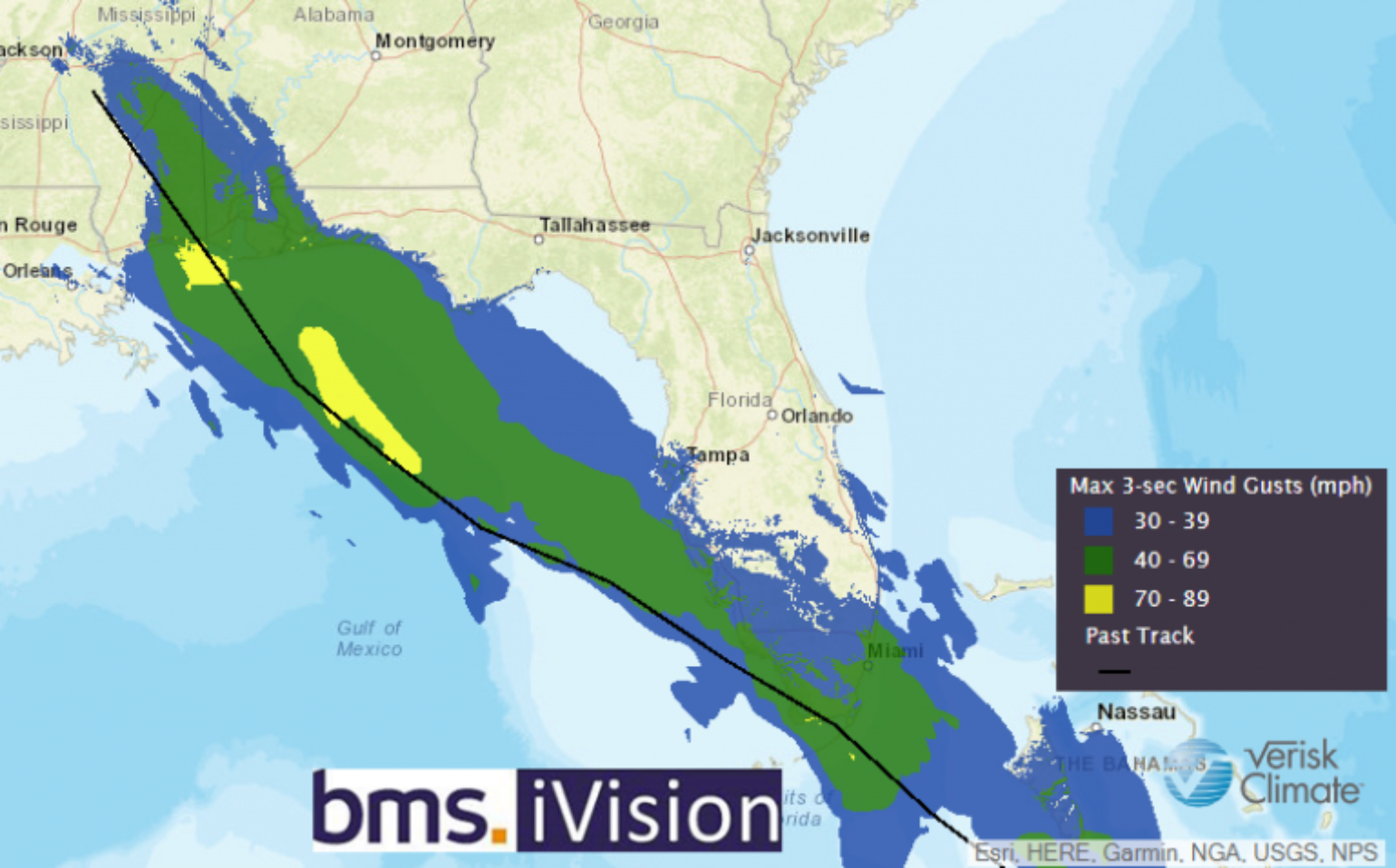
Gordon Recap
There are limited reports of damage near the location of Gordon’s landfall. Current damage reports in Louisiana, Mississippi, Alabama, and Florida indicate only minor coastal flooding, power outages affecting up to 29,000 people and damaged trees. The insured losses from Gordon should be relatively limited due to the overall small concentration of high winds which were mostly on the right side of the center of the storm as it made landfall near the Louisiana/Alabama boarder on Monday night. The maximum sustained wind speeds at landfall were 70 mph, which is just shy of Category 1 on the Saffir-Simpson hurricane wind scale. Because Gordon was not a Category 1 hurricane at landfall, the major risk modeling companies will not be issuing any loss guidance, but losses should be lower than after Hurricane Nate, which impacted the same general area in 2017. The most severe damage seems to be mostly confined to coastal islands like Dauphin Island, AL, which have strict frame building codes and likely high wind deductibles. But seeing even minor damage to some of these structures suggests the properties are very vulnerable to wind and surge, and that it’s only a matter of time before the landscape changes, similar to what has been observed on the Bolivar Peninsula in Texas after Hurricane Ike in 2008.
Florence’s Future
As I mentioned in Monday’s post, there is a high degree of uncertainty in the long-range track for Florence. This is the very reason why the National Hurricane Center (NHC) only issues a five-day forecast, and even its five-day forecast, which is historically one of the most skillful, still has an error of 198 miles. Only 60-70% of the time, the track of the storm can be expected to remain within the NHC cone of uncertainty. Therefore, it is far too soon to speculate what, if any, impact Florence may have on the U.S. East Coast next week.
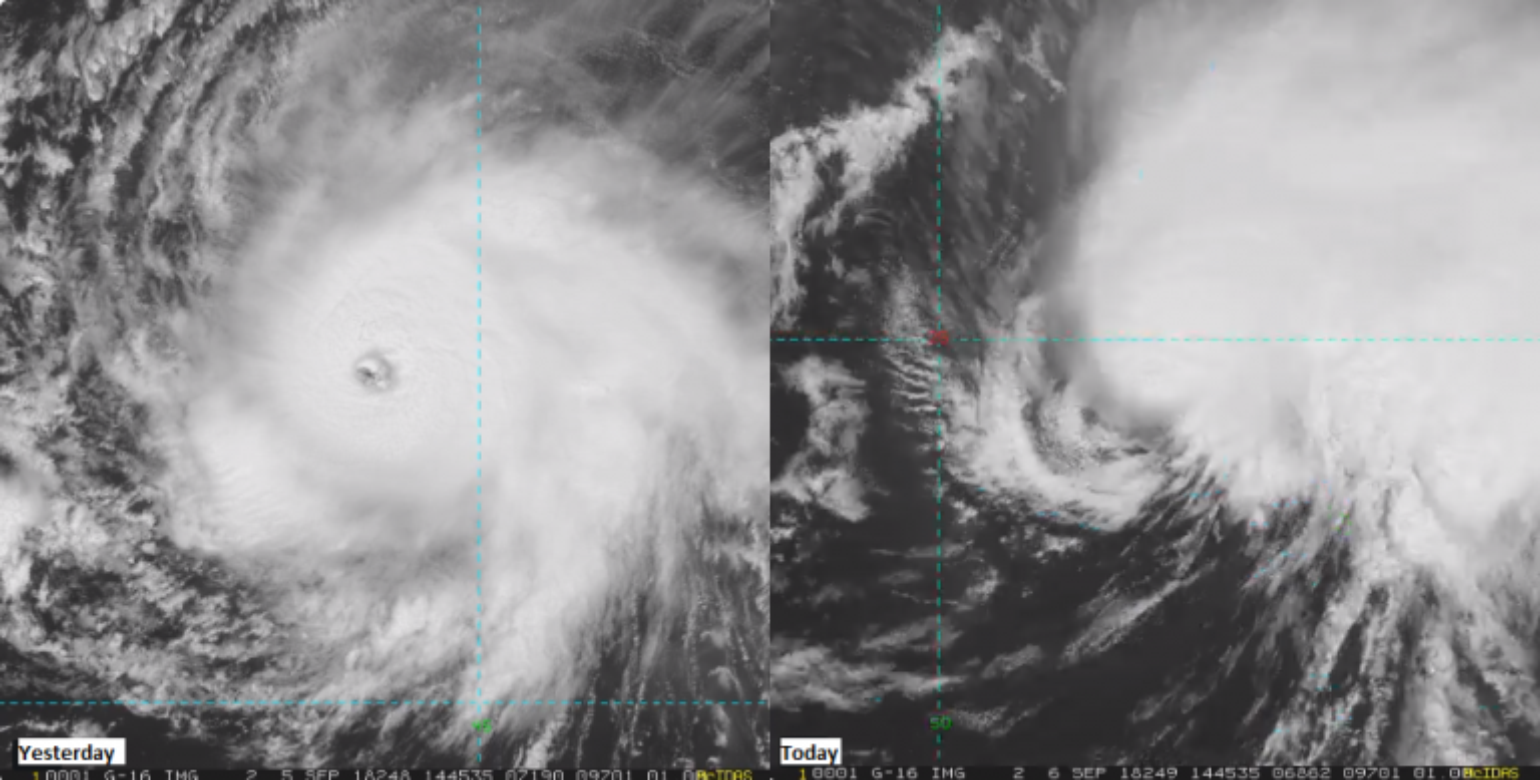
Florence continues to fluctuate in intensity and, amazingly, it popped to a Category 4 hurricane yesterday in very hostile conditions. Today, however, those unfriendly conditions are impacting Florence’s strength, as it is currently down to a small Category 2 storm. As mentioned previously, the weaker Florence is, the more likely it will stay on a westward track. In fact, the animation below shows Florence tracking through an area of dry, dusty air known as the Saharan Air Layer (SAL), but still maintaining its intensity as it moves in a more northwest direction.
Dry air, don't care pic.twitter.com/PYIFbCvg66
— Michael Lowry (@MichaelRLowry) September 6, 2018
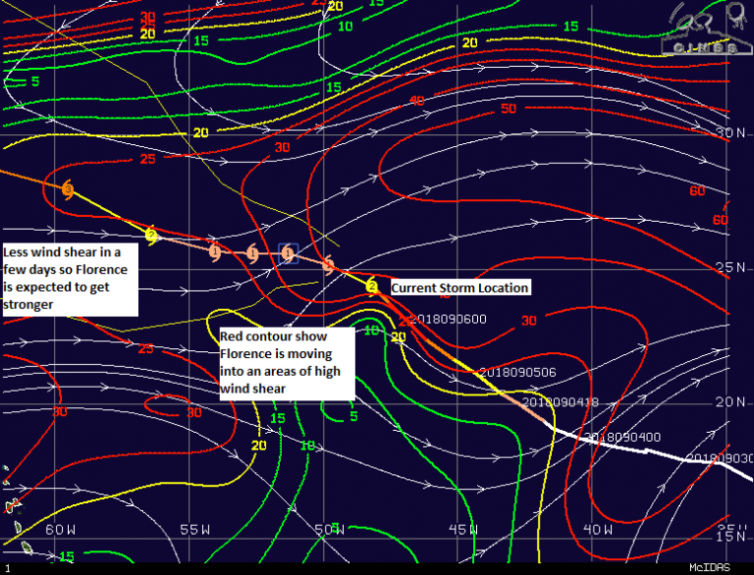
At the same time Florence is tracking through an area of high SAL, it is also fighting an area of high wind shear. One of the best sites to understand current wind shear and SAL is via the University of Wisconsin Cooperative Institute for Meteorological Satellite Studies.
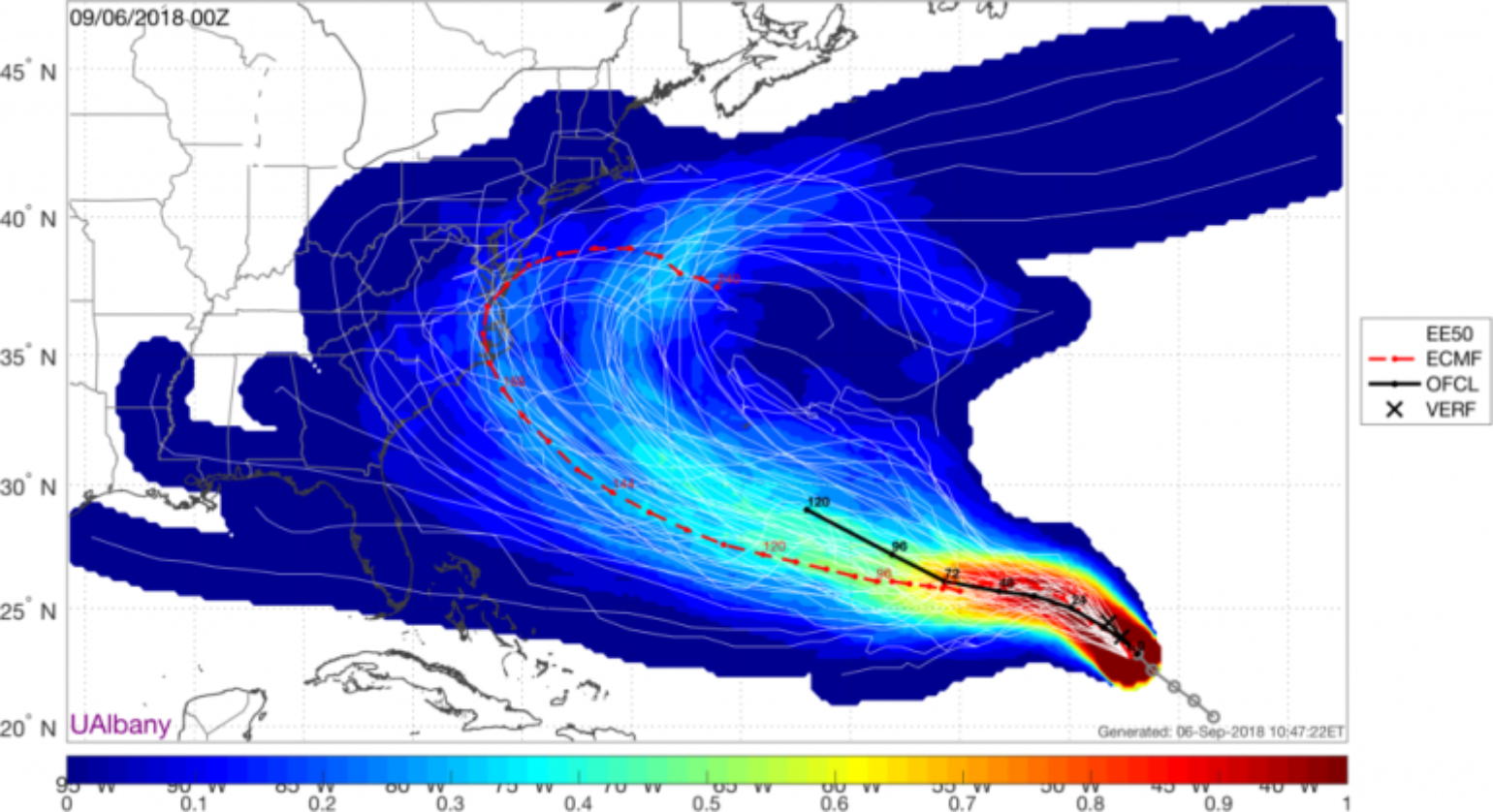
The various forecast model ensembles are currently the best tool to understand the forecast uncertainty. In the short term, the forecasts are usually very good, with only an error of few hundred miles. In the case of Florence, what happens beyond five days is anyone’s guess. Currently, the spread from these various ensembles is HUGE, showing possible tracks from Florida to Newfoundland. However, over the last several days, there is growing confidence in the ensemble forecasts that Florence will track westward - a growing threat to the East Coast of the U.S. But, the ensembles are exhibiting a high spread in all directions. The source for much of the uncertainty is a possible inflection point that could occur on Sunday as a trough of low pressure passing to the north could provide an escape route for Florence. If the storm misses this trough of low pressure, the chance of eastern U.S. impact increases, as a strong ridge of high pressure blocks any possible escape to the north and allows Florence to track westward until late next week.
The other tools that can utilized at this time are historical storm tracks and climatology. Never in the history of the Atlantic Basin track set has a named storm in Florence’s current location ever reached the U.S.
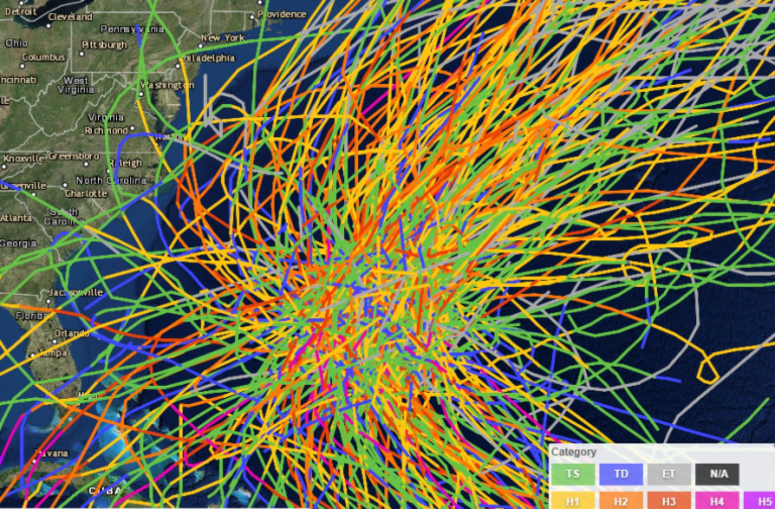
The same analysis suggests that of the 220 historical storms that have tracked within 200 miles of the NHC five-day forecast location south of Bermuda, only a handful have reached the U.S., with even fewer being notable events like the 1933 Chesapeake - Potomac Hurricane.
Given the large amount of uncertainty, now is the time to prepare. The Insurance Institute for Business and Home Safety has nine key things insured homeowners should do to limit overall damage.https://disastersafety.org/hurricane/reduce-hurricane-damage-to-homes/
In summary, the current shear is forecasted to take its toll on Florence. I expect that once Florence tracks through the high areas of wind shear, the combination of much warmer waters in the path of the hurricane will strengthen and expand the storm. Expect Florence to be stronger in intensity and a much larger sized storm as it moves closer to Bermuda, the location that has the highest probability of impact given the various forecast ensembles.
The Parade Continues
The NHC continues to watch for development of soon-to-be named Helene, which is currently centered several hundred miles WSW of the Cabo Verde Islands and has a 90% chance of named formation over the next five days. The cloud mass now coming off of Africa has the potential to be Isaac with a 50% chance of named storm formation during the same timeframe. As I have been saying, these two system have a high likelihood of tracking west across the Atlantic, where conditions are more conducive for strengthening, and could threaten the Caribbean and coastal U.S. in two weeks. But, there are signs that after later next week any new activity should start to wane across the Atlantic Basin. The heart of this hurricane season might only be what develops over the next week as the end of the month looks quiet.