Forever changed
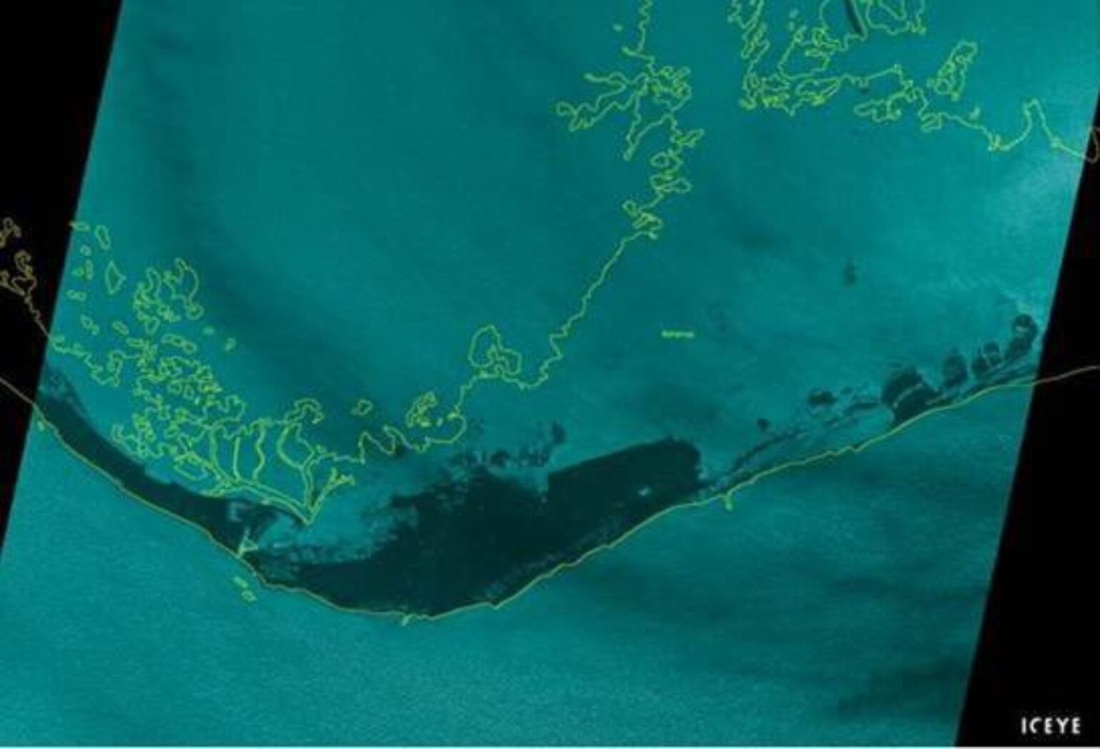
After pummeling the Bahamas for the last 48 hours, the images now surfacing verify that the northern islands have been devastated and may take years to recover. Hopefully, the Caribbean Catastrophe Risk Insurance Facility (CCRIF) will help with rapid infusion of cash to assist with immediate post-disaster priorities, but the damage at this point is extensive. The Red Cross suggests in its early estimates that over 13,000 homes have been destroyed, which does not likely take into account any damage that is occurring on the island of Grand Bahamas. In fact, ICEYE, which is a tech company using satellite radar to map flooding, provided this image yesterday of the storm surge on Grand Bahamas and Freeport, which shows much of the island underwater.
Once again, it’s remarkable that a major hurricane has been stationary just east of where 4.6 million people live along the South Florida coastline. Further, the eye of the hurricane, which could have brought relatively calm conditions to Freeport, Bahamas, was outside that city by just 20 miles and, instead, Freeport has experienced the onslaught of northwesterly 100 mph winds for over 36 hours.
It is already clear that Hurricane Dorian will have its place in history achieving several meteorological records and, once again, Philip Klotzbach has been keeping track of the notable facts.
Impact on Florida
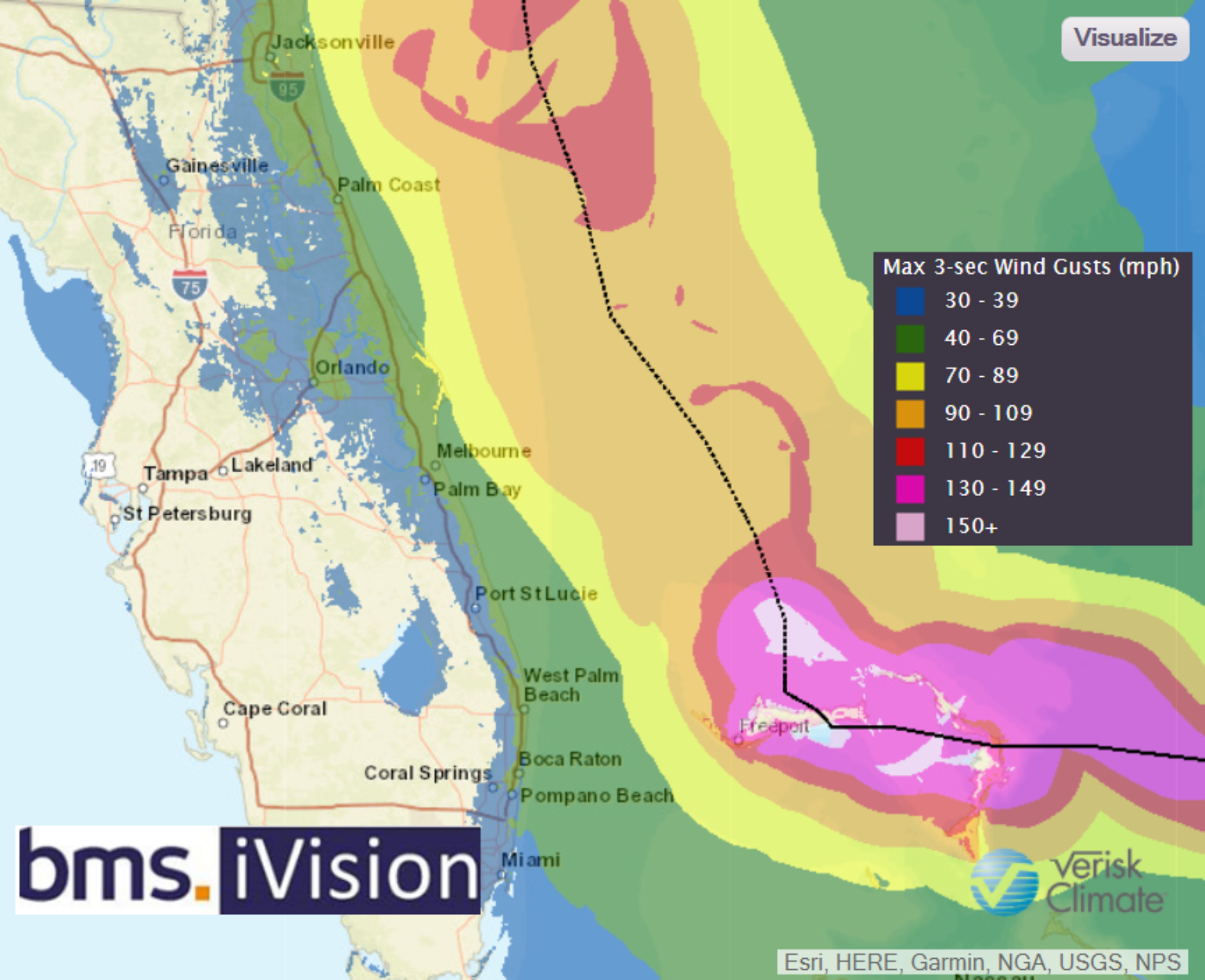
Today Dorian will begin its long-awaited movement to the north, with much riding on the exact timing/magnitude of the turn. Intense hurricanes like Dorian wobble back and forth, so what might look like a turn towards the north may actually be this kind of fluctuation. These wobbles could also be eyewall replacement cycles, which have occurred over the last 24 hours, expanding the wind field of Dorian, as expected. Currently, the radius of maximum winds is 25 miles from the center as opposed to yesterday when it was only 8 miles. It seems that overnight Dorian’s satellite appearance has degraded somewhat as it churns up cooler water from below the ocean surface while it remains stationary just north of Grand Bahama Island. The eye remains well-defined, but it’s not quite as warm nor as symmetrical as it was when it first moved into the Bahamas 48 hours ago. Additionally, the upper-level outflow on the western side of the storm is becoming restricted as the storm begins to encounter some westerly wind shear. Thus, Dorian will likely stay at a weaker Category 3 hurricane over the next 24 hours as it tracks along the Florida coastline roughly 75 miles offshore. This should result in the majority of the hurricane-force winds staying offshore as well, since these winds will only extend about 40 - 50 miles from the center of the storm. So, it seems that the overall impacts will be similar to Matthew in 2016 or less so. For more details, please refer to yesterday’s BMS Tropical Update.
Impact on the Carolinas
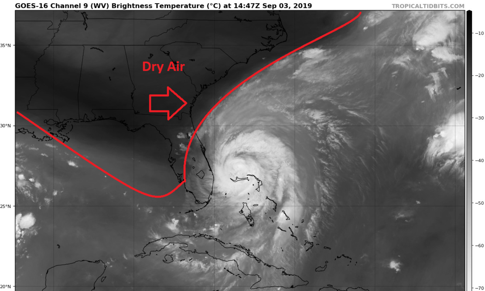
The water vapor satellite image below shows the trough starting to enter the Florida panhandle that will finally lift Dorian off the Bahamas. The trough contains shear and dry air that will aid in weakening the storm further as time progresses. However, Dorian is still a Category 2 hurricane so a lot of weakening must occur for it to become a minimal event to the Carolinas.
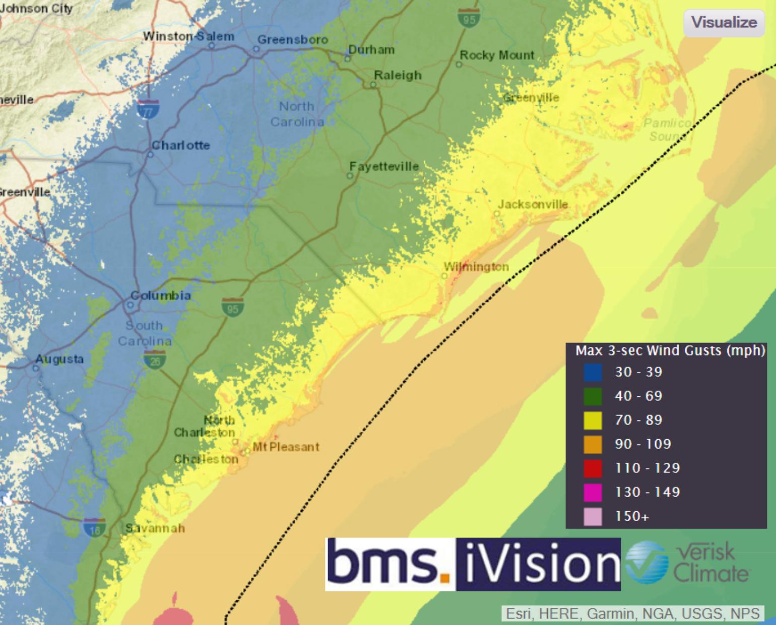
The overnight model guidance seems to trend for a higher impact on South Carolina and North Carolina as the models continue to have difficulty understanding the strength of the Bermuda High, so it is still possible that a Category 1 or 2 hurricane could make landfall in the Carolinas. Most of the model ensemble guidance suggests a track with the center of Dorian just offshore with no landfall, but the western eyewall could pass over parts of the coastline such as Cape Fear or Cape Lookout. Currently, there is a 90% probability that the coastline of the Carolinas could see hurricane-force winds. Therefore, the overall effects of wind could be higher along the Carolinas than what is observed in Florida today and tomorrow.
While there are many variables to consider when evaluating the potential outcomes of Dorian, one in particular may stand out. In 2014, when Category 2 Hurricane Arthur tracked over the outer banks of North Carolina, it became the only Category 2 hurricane thus far to make U.S. landfall and not result in an insured loss, according to Property Claim Services. So there is a chance that the resiliency and the nature of Dorian’s structure as it passes along the coast of the Carolinas may also result in minimal loss, but this notion will all depend on the storm’s track, just as it has along the Florida coastline. In addition to Arthur, hurricanes Ophelia in 2005, Irene in 1999, Gladys in 1968 and Donna in 1960 are all good analog events that could be used to help understand impacts from Dorian over the next 24 hours.
At this time it is too early to determine the severity of inland flooding and storm surge, but in a faster-moving and recurving storm, the impact of the storm is typically less than if the hurricane were to approach at a perpendicular angle to the coastline like Florence did last year. Tomorrow we will have a much better idea of these impacts.