California’s typical wildfire season takes place in the fall, with the majority of large insured loss events occurring in October. Of the 27 large insured wildfire losses occurring in California since 1964, 16 have occurred in the months of October, November and December, and have accounted for 87% of the total losses over that time span. After an already long and destructive wildfire season for much of the western United States (which includes the Carr Fire and the Mendocino Fire Complex in California in July and August) that has resulted in over $1.3 billion of insured loss, major fires have again ignited in California on Thursday, November 8th. Much of the state is under an elevated fire risk, with almost 10,000 square miles under critical fire conditions according to the National Weather Service. Red flag warnings have also been issued, which represent conditions of very low humidity and high winds that tend to result in extreme fire behavior.
The cause of the Camp Fire has yet to be determined, but it started in the early hours of November 8 near the Plumas National Forest. The first firefighters to arrive found about 10-15 acres burning. Wind gusts of nearly 50 miles per hour helped accelerate its growth and spread it into the town of Paradise, CA.
Explosion of the #CampFire in 35 critical minutes as seen from @nvfirecams @AlertWildfire at @CAStateParks Oroville camera site. https://t.co/l1SvJDQHVW @unevadareno @UCSanDiego @uoregon pic.twitter.com/HgzIg7ttRe
— Nevada Fire Cameras (@nvfirecams) November 9, 2018
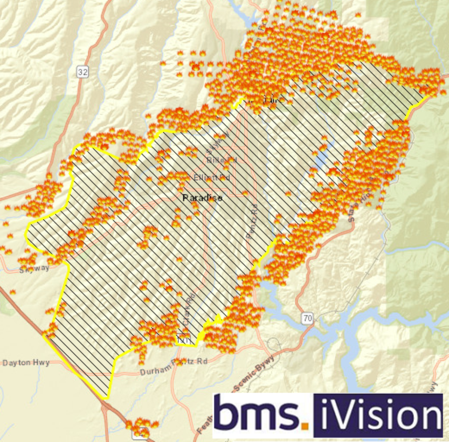
Initial reports suggest well over 2,000 residential and commercial structures have been destroyed by the fast moving fire which quickly spread embers into the center of town. The fire is currently encroaching on Chico, CA, and Highway 99 and several thousand other structures are still threatened by this fire. It should be noted that typically when fires burn over 1,000 structures, it’s safe to say that the insured loss will likely be above $1 billion.
Abandoned cars, burned forests. This is what the aftermath of sheer terror looks like in Paradise pic.twitter.com/rzLCdxeBgf
— Brian L Kahn (@blkahn) November 9, 2018
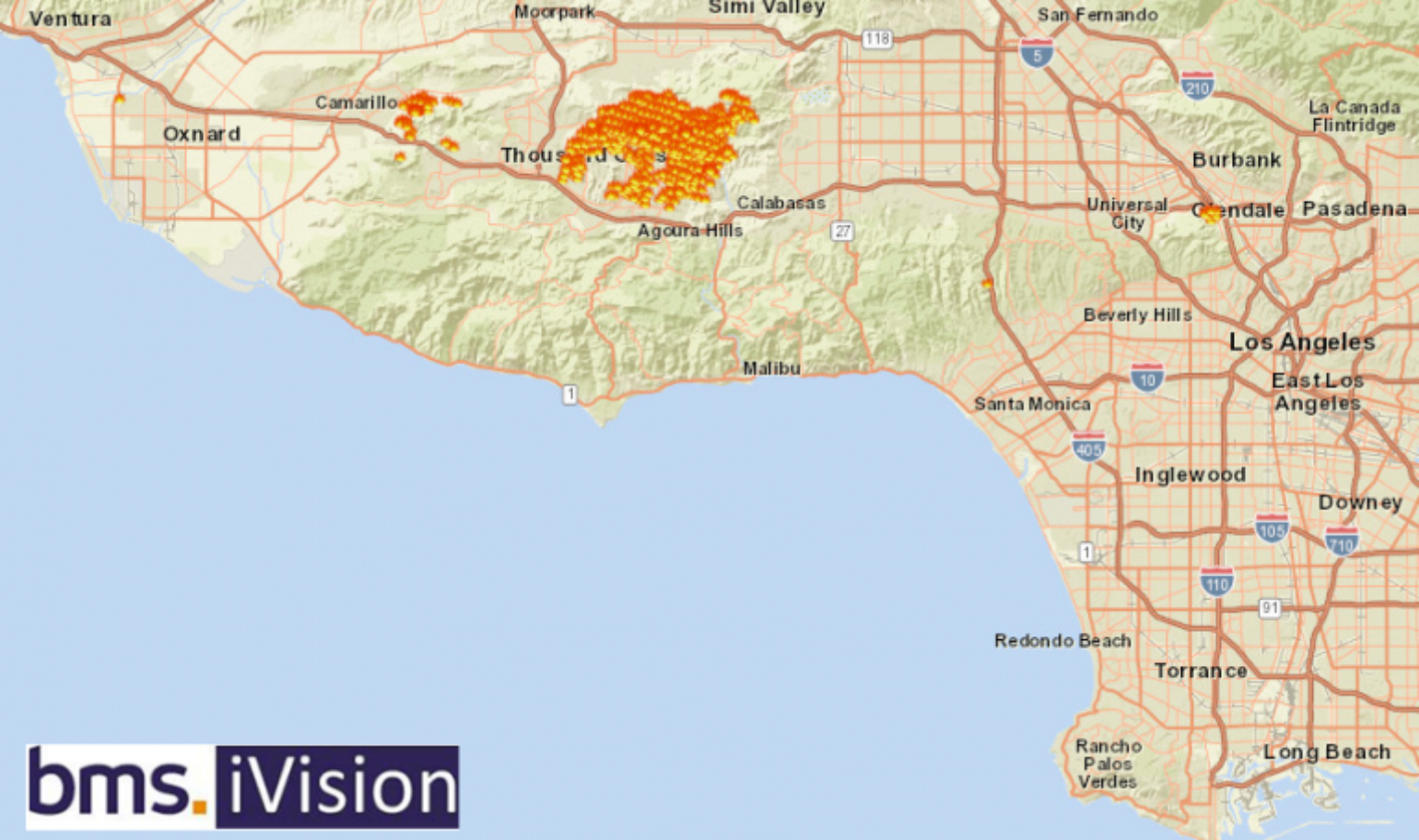
Elsewhere across the state, the Hill and Woolsey fires ignited Thursday in southern California near the Thousand Oaks, CA community and began spreading rapidly. Evacuations have been issued this morning for the entire coastal community of Malibu, CA. Damage has been reported from the Hill fire, but the full magnitude is currently unknown. Just to the south, the Woolsey fire has jumped the 101 highway and has destroyed multiple structures according to Ventura County Fire Department. The Malibu area is under mandatory evacuation due to both of these fires, as authorities expect they could burn all the way to the coast and clearly there is major exposure in the current evacuation area.
In total, there are 13 known fires currently burning in California. With extreme fire conditions occurring, many of these fires will be difficult to contain and it is expected that several insured loss events could result from any of these fires. BMS iVision does have active wildfire layers, such as the current satellite derived hot spots and when issued, the integrated reporting of wildland fire information perimeters will be shown. Both of these resources allow the user to access the scenario based tools within iVision to understand the exposure and damage potential from these fires.