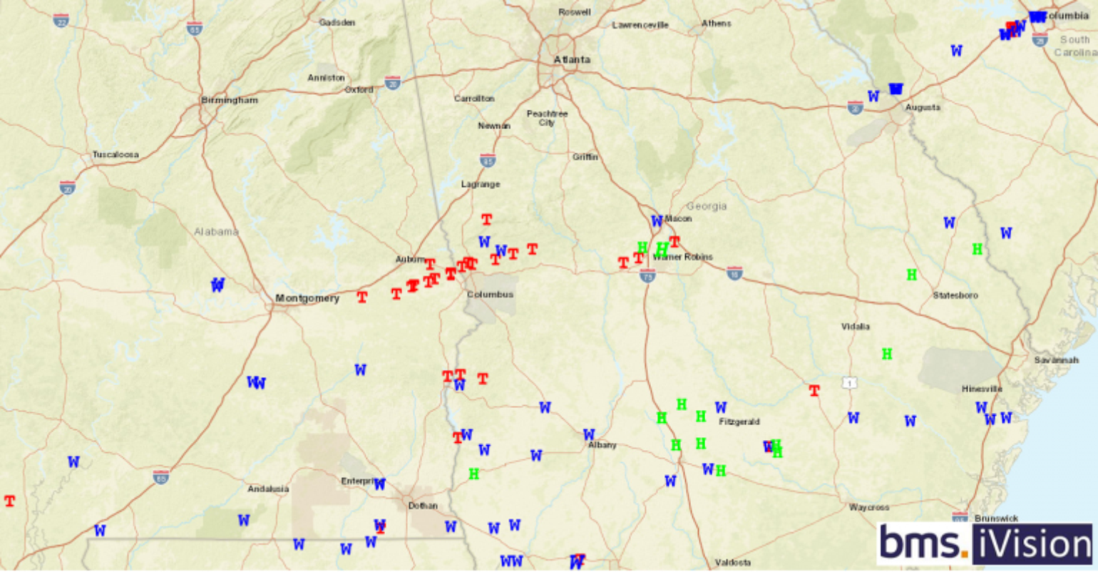
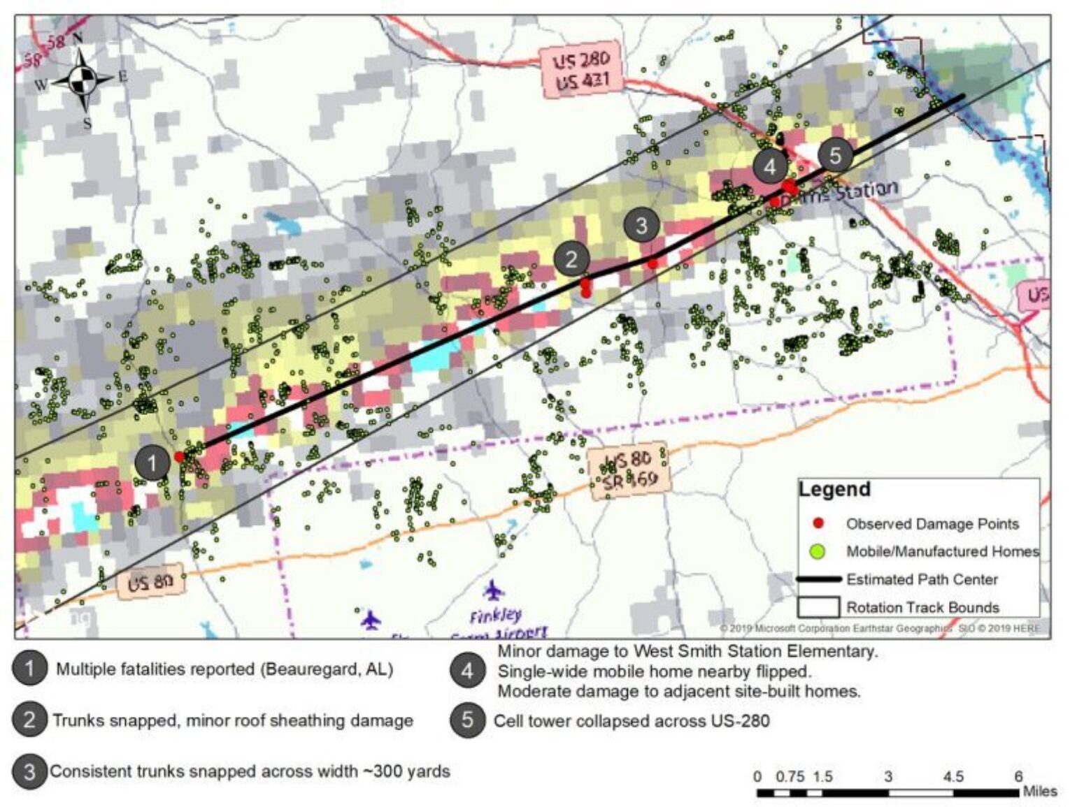
The familiar saying is that March can start in one of two ways: like a lion or a lamb. Unfortunately, this year it has come in roaring like a lion, with the occurrence of a very active outbreak of severe weather that has moved across the southeastern U.S., spawning numerous tornadoes (Filter NOAA Storm Reports suggest 39 tornadoes). The hardest hit areas seem to be Beauregard and Smith Station, AL, with initial damage reports suggesting the tornado travels 67 miles with a maximum width of 1 mile and had a maximum intensity of an EF4 tornado with 170 mph winds. So far this tornado was the cause of all 23 reported fatalities. The Talbotton, GA, tornado could have also experienced a low to mid-level EF4 (166 - 200 mph) tornado and could actully be part of the same tornado that tracked over Beauregard and Smith Station, AL. Cairo, GA experienced an EF2 (120 mph) tornado, but data will continue to be analyzed before finalizing the rating. Overall, reports (only 16) of severe hail and other winds associated damage (62 reports) with this severe weather outbreak were relatively limited, but some insurance loss could result from these perils as well.
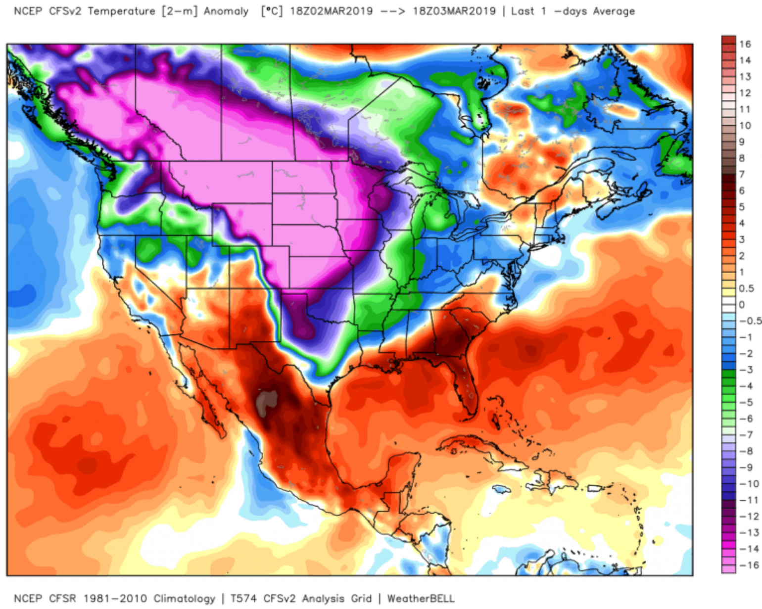
The catalyst for this event was an area of low pressure moving across the Lower Mississippi Valley toward the Mid-Atlantic coast. In fact, if you look at the temperature anomaly from yesterday afternoon, it was a classic signature of a large tornado outbreak, similar to the late-April Tuscaloosa tornado outbreak of 2011. With record cold occurring in the north-central plains and ample warm moist air along the southeast feeding off the above-normal Sea Surface Temperatures (SST) in the Gulf of Mexico, the pattern is set for severe weather.
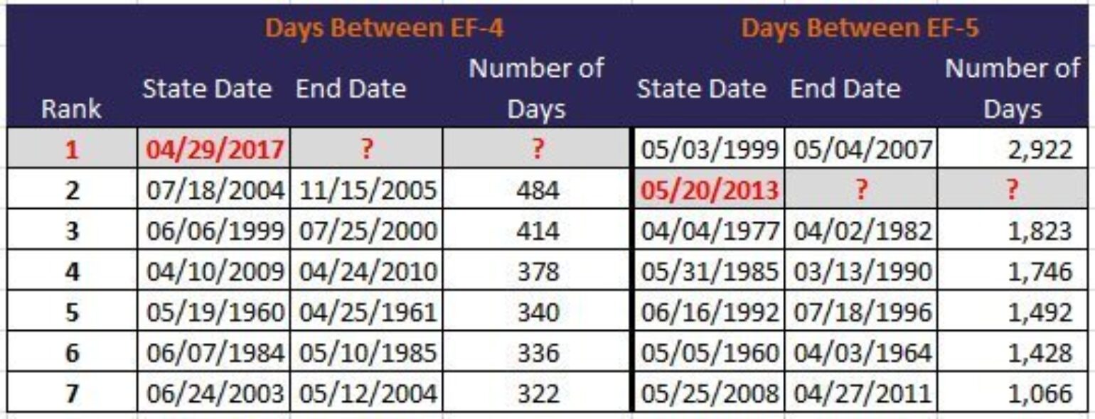
Sadly, many people lost their lives even with this ample warning. With the death toll currently at 23 and potentially still rising, this tornado outbreak is the deadliest since May of 2013 when 24 people were killed in Moore, OK, and the deadliest day for tornadoes in Alabama since 2011.Given the rating of the Smith Station, AL tornado is now an EF4, this ends the remarkable drought of an EF4 tornado. According to the source, U.S. Tornadoes Violent tornadoes have caused 63.1% of all deaths despite the only accounting for 1% of all tornadoes in the historical record.
Given the rating of the Smith Station, AL tornado is now an EF4, this ends the remarkable drought of an EF4 tornado. According to the source, U.S. Tornadoes Violent tornadoes have caused 63.1% of all deaths despite the only accounting for 1% of all tornadoes in the historical record.
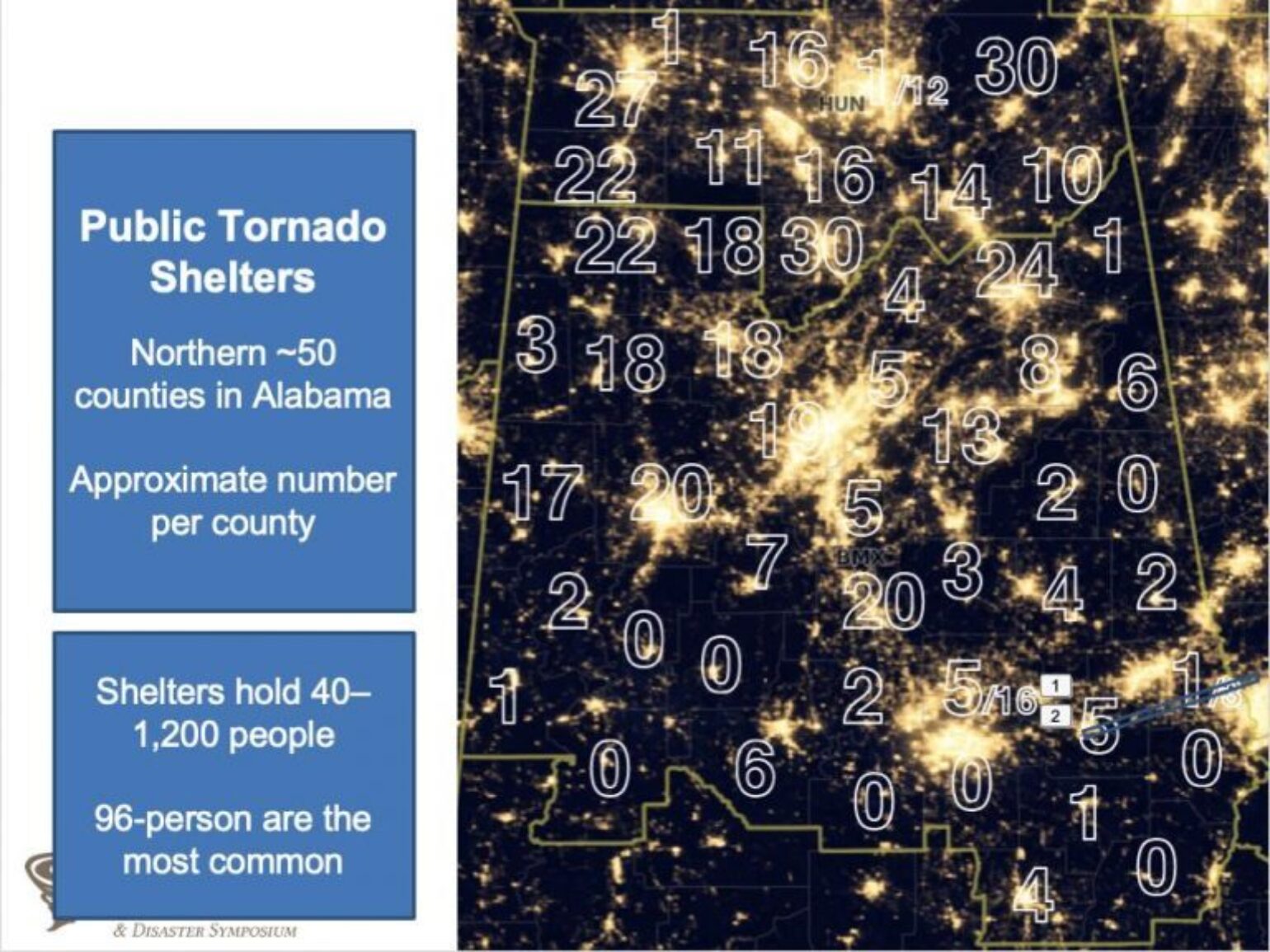
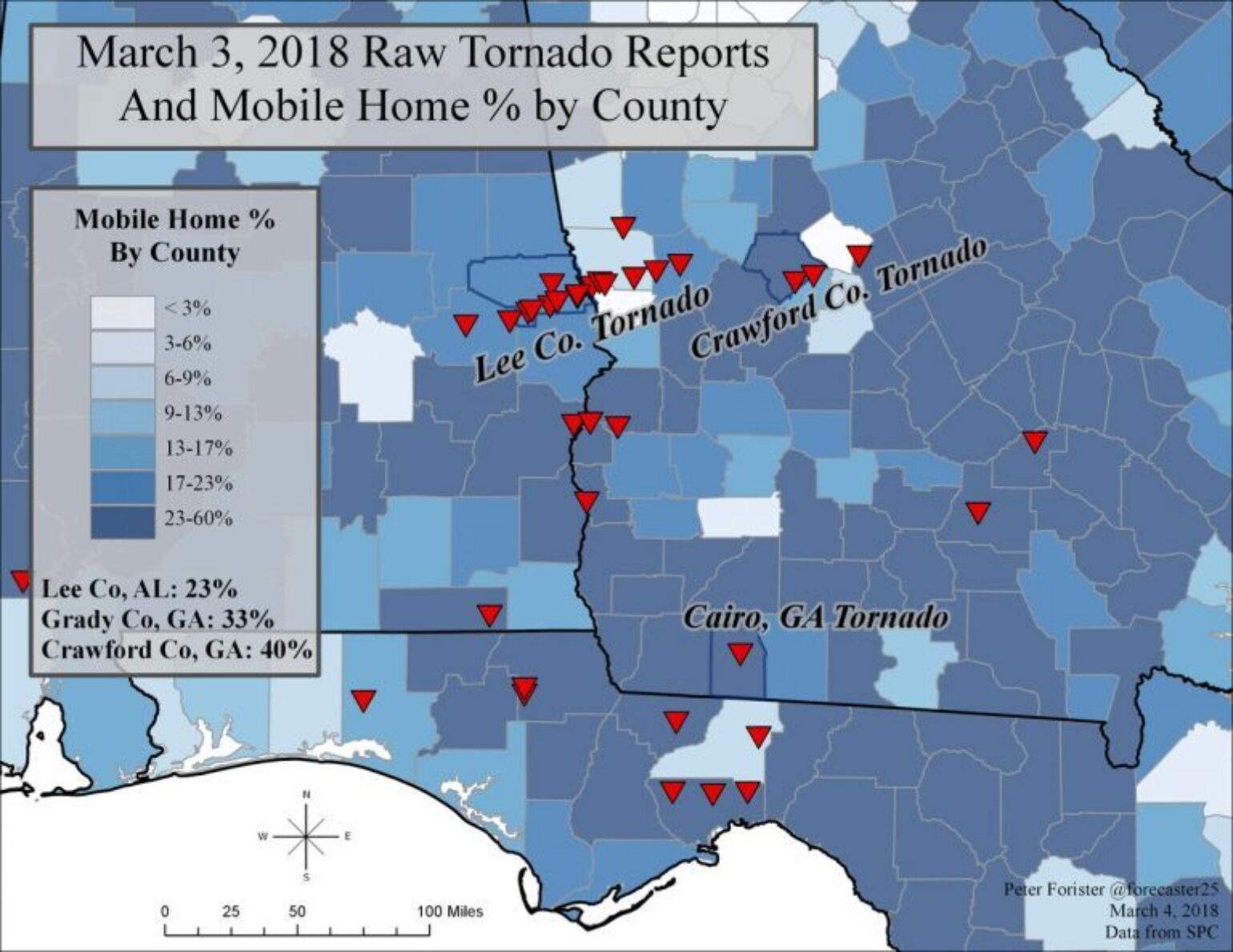
It is notable that the prevalence of images of driveways with debris everywhere, but no indication of foundations, suggests a large number of mobile homes were likely in these locations, perhaps contributing to the loss of life. Mobile homes tend to be lighter and have much less stable foundations than a typical single family home. In fact, data from Stephen Strader and Dr. D.S. LaDue shows there are very few community tornado shelters in the part of Alabama hit by the tornadoes. Mobile homes are a big part of the housing stock across the deep south which is troubling, as even the weaker tornadoes or strong wind storms can destroy such structures. When you combine this with the huge growth in exposure to the tornado hazard across Dixie Alley, the insurance industry is bound to continue to experience loss from events like this into the future, even if it has been some time.
Unfortunately, the forecast calls for another storm systems later this weekend and another duing the middle of next week that could lead to more outbreaks of severe weather. In fact, last week the large forecasting company AccuWeather predicted 1,075 tornadoes will occur in 2019. This is a bold prediction that has drawn some scrutiny as being very unscientific. It is expected severe weather usually occurs across Dixie Alley in the early spring, as this is the climatological peak for storms before the focus shifts to the central plains. AccuWeather believes warmer-than-normal SST over the Gulf of Mexico will lead to increased moisture transport from the Gulf over the region and, ultimately, a higher frequency of severe weather this season. I think the forecast is, bold, but the insurance industry needs companies and other researchers to push forecasting, but also state the uncertainties in such forecasts as guidance is feasible at longer lead times, but there is substantial variability. A number of factors that influence seasonal tornadoes include the state of the El Niño Southern Oscillation, Pacific and Atlantic SST profiles and seasonal wind shifts like the Madden-Julian Oscillation or the global wind oscillation. For the upcoming season, there is a weak ongoing El Niño event which, typically, implies the unstable conditions favorable to tornadoes are less likely over the Great Plains. But the Gulf of Mexico is exceptionally warm, and I know first-hand the snowpack over the northern plains and Rocky Mountains are healthy, which suggests more instability over the U.S. Only time will tell how this plays out, but the tornado drought appears to be over, and insurance companies are, yet again, facing loss from the raw destruction that can occur from severe weather.