Just two years ago we were talking about Hurricane Hermine breaking the 11-year hurricane drought in Florida. With all of the recent U.S. hurricane activity, it’s easy to forget that this drought even occurred, but let’s remember that there are large gaps of the U.S. coastline that have not experienced a major hurricane in a long time. The Panhandle of Florida is one of them, as it has not seen a major hurricane in well over 10 years. For context, iPhones had not yet been released when Hurricane Dennis impacted the Panhandle in 2005. Over this time period, there has also been rapid growth of coastal communities around Destin and Panama City, FL. There are certainly new residents in this area who have never experienced a major hurricane.
Forecasted Track and Intensity
There is good news that Hurricane Michael did not rapidly intensify overnight, and it only showed a small increase in intensity. A fully concentric eyewall has yet to develop, with dry air and wind shear being the likely cause of the lack of rapid intensification overnight. There are some signs that significant strengthening has already began today, as some lightning and deeper convection seem to be initiating eyewall development, and the overall storm seems to be consolidating. Michael is located 360 miles south of Panama City, FL. The current wind speed is 110 mph which is already an increase of 20 mph from the 4 AM NHC Advisory and barometric pressure is 965 mb.
While there is still some uncertainty around Michael’s intensity at the time of landfall, the model track guidance has been accurate since this weekend. The projected path has been targeting an area between Destin and Port St. Joe, FL, with a likely probability (60%) of hurricane-force winds impacting the capital city of Tallahassee.
In the BMS Tropical Update yesterday, I touched on several factors that could lead to Michael's strengthening and also some that may limit it, such as the lack of a Gulf of Mexico Loop Current and just slightly cooler Sea Surface Temperatures (SST) that Michael will encounter along its track northward. A lot of the intensity questions at landfall will depend on the circumstances over the next 24 hours and whether Michael can intensify enough before making landfall tomorrow afternoon. Currently it seem to be progressing to major hurricane status later today.
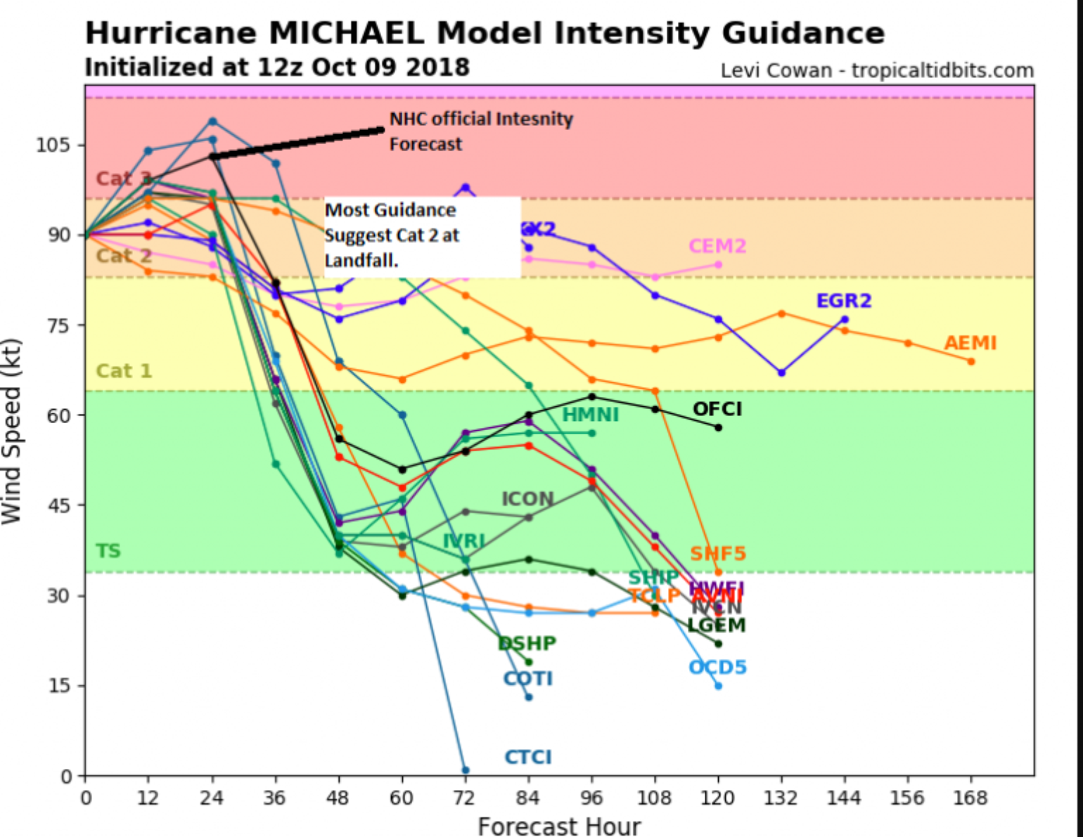
Above is an ensemble of intensity forecasts. There is agreement that Hurricane Michael will likely be at least a Category 2 storm at landfall, with some of the more reliable hurricane-specific intensity models suggesting that strengthening will occur right up until landfall, which is an important point. Some models suggest an even stronger storm which needs to be watched. Currently, the NHC forecast is still suggesting the wind speed at the time of landfall is expected to be 126 mph, with higher 3 second gusts possible. The overall size of the storm, which is sometimes referred to as the RMAX, is a bit unknown at this time, as eye wall replacement cyclones and the overall intensity of the storm will determine this over the next 24 hours. The forward motion of the storm at landfall appears to be relatively fast (16 mph), which could extend damage further inland as the storm weakens. These stronger inland winds will likely cause power failures and downed trees over a large area. Wind gusts of 70 mph are likely over southwestern Georgia.
Wind Risk
Using Verisk Weather Solutions forecasted wind swath allows BMS clients to better understand wind impacts to specific risks. This high-resolution model wind field shows hurricane-force winds rapidly weakening inland due to a frictional effect, which is important when determining the overall damage estimation to inland risks.
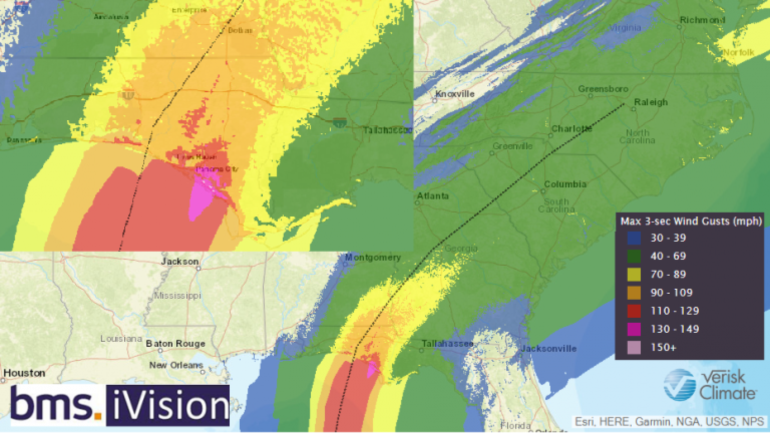
However, this predicted weakening of winds inland does not mean that the winds won’t be strong enough to knock down some trees. As mentioned in yesterday’s update, the tree cover in the Florida Panhandle, particularly from Apalachicola up to Tallahassee, is dense. This is why much weaker Hurricane Hermine caused such extended power outages that lasted weeks in some locations. It does not take a major hurricane to cause significant wind impact in the Florida Panhandle - the peak wind gust reported in Tallahassee from Hurricane Hermine was only 64 mph. Clearly Michael’s degree of disruption will be several times worse in terms of power outages when it comes ashore. With all of the foliage and the lack of major hurricane activity over the last 10 years, a natural culling of weak and damaged trees and branches can be expected. And, of course, even tropical storm-force winds can cause minor damage to structures. This could complicate the overall loss estimate from the modeling companies, although they do try to take into account tree density around individual risks.

Tornado Risk
An often overlooked aspect of a landfalling hurricane is the tornado threat. I made several mentions to this prior to Florence making landfall, which resulted in over 40 confirmed tornadoes. I would also expect several dozen tornadoes to occur with Michael as it comes ashore and races across the southeastern states.
Storm Surge Risk
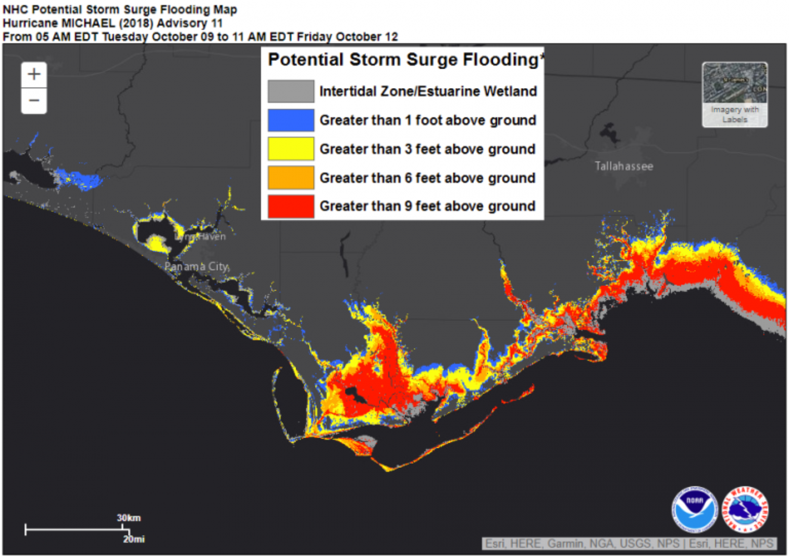
Likely one of the biggest stories from Hurricane Michael will be the storm surge. I am sure some storm surge records will be broken. The Florida Panhandle is very susceptible to this, but the extent of the surge will depend on the overall track and intensity of the storm. To illustrate, Dr. Risk Luettich at University of North Carolina Chapel Hill ran a few simulations along the NHC cone of uncertainty which shows that the exact track of Hurricane Michael will determine the storm surge, estimated to be as high as 12 feet if the worst case scenario develops between Indian Pass, FL and Ceder Key, FL.
As of Tuesday morning 5 AM EDT advisory 11, the surge remains highly dependent on storm track. Images show surge+tide if #Michael follows the forecast track, the left edge of the cone of probability, & the right edge of the cone. pic.twitter.com/LsJlKFhISP
— Dr. Rick Luettich (@RLuettich) October 9, 2018
The best tool for estimating storm surge is the NHC storm surge inundation product, which provides a detailed look at the water level that is expected above the ground. The catastrophe models have a good handle on the various storm surge scenarios that are possible based on the track and intensity.
Early Insured Loss Estimates
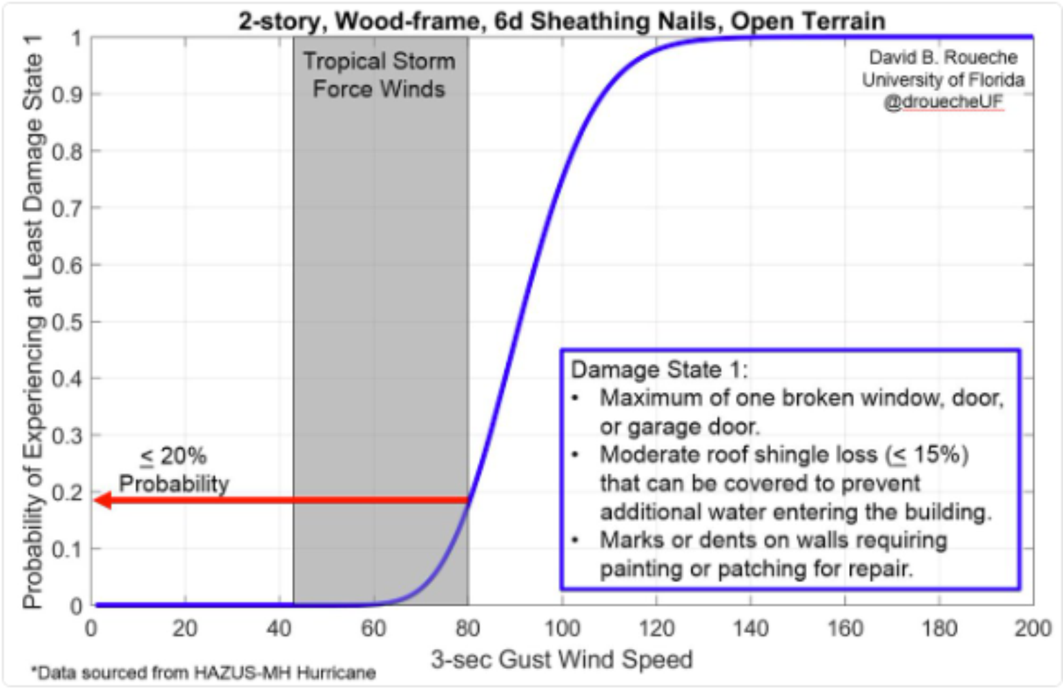
Today the catastrophe modeling companies will continue to zero in on stochastic model event selection. Based on the historical catalog, there are plenty of comparable events for the companies to use for loss analysis. As pointed out, there are some unknown variables that are a bit harder to model, such as tree fall and power outages. Florida has some of the best building codes in the country, however the standards in the Panhandle are not as high as southern Florida. This will be key along with the construction quality over more interior parts of the panhandle and Southern Georgia. However, the degree of damage from lower wind speeds is often overlooked for older wood frame building which are common in the region.
Overall, insured loss from wind and storm surge from the historical and modeled stochastic events appear to have a range between $1B and $3.5B. The actual loss will depend highly on the parameters and location of landfall. If the storm tracks to the east side of the NHC cone of uncertainty, which is a rural area, damage should be lower, but tracking too far to the east will increase inland loss in Tallahassee.