Miles Will Matter
Hurricane Dorian is a marvel of nature. Below is a one-minute satellite image of Dorian as the sun rose this morning. Dorian has maintained a circular and symmetrical eyewall throughout the day and night, and reconnaissance aircraft data has continuously supported a high-end Category 4 storm with slight fluctuations in intensity. In the latest advisory, Dorian has achieved Category 5 status and could stay at this strength for the next 24 hours since ocean heat content is higher over the Bahamas. Without deeper water to upwell cold water, there aren’t many factors that could weaken Dorian over the next day besides its slow motion and an increase in wind shear, which won’t occur for several days when Dorian turns north midweek. Unfortunately, Dorian will likely have a devastating impact on the northern Bahamas over the next 36 hours, which could change the landscape on some of the islands for decades.
Longer loop as sun rises.
— Dakota Smith (@weatherdak) September 1, 2019
My goodness. pic.twitter.com/ePNNDgZpPB
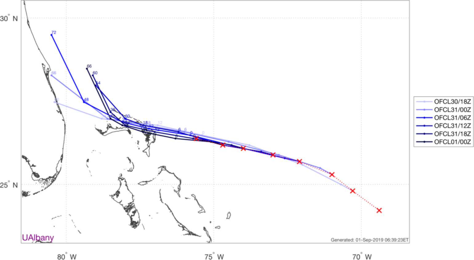
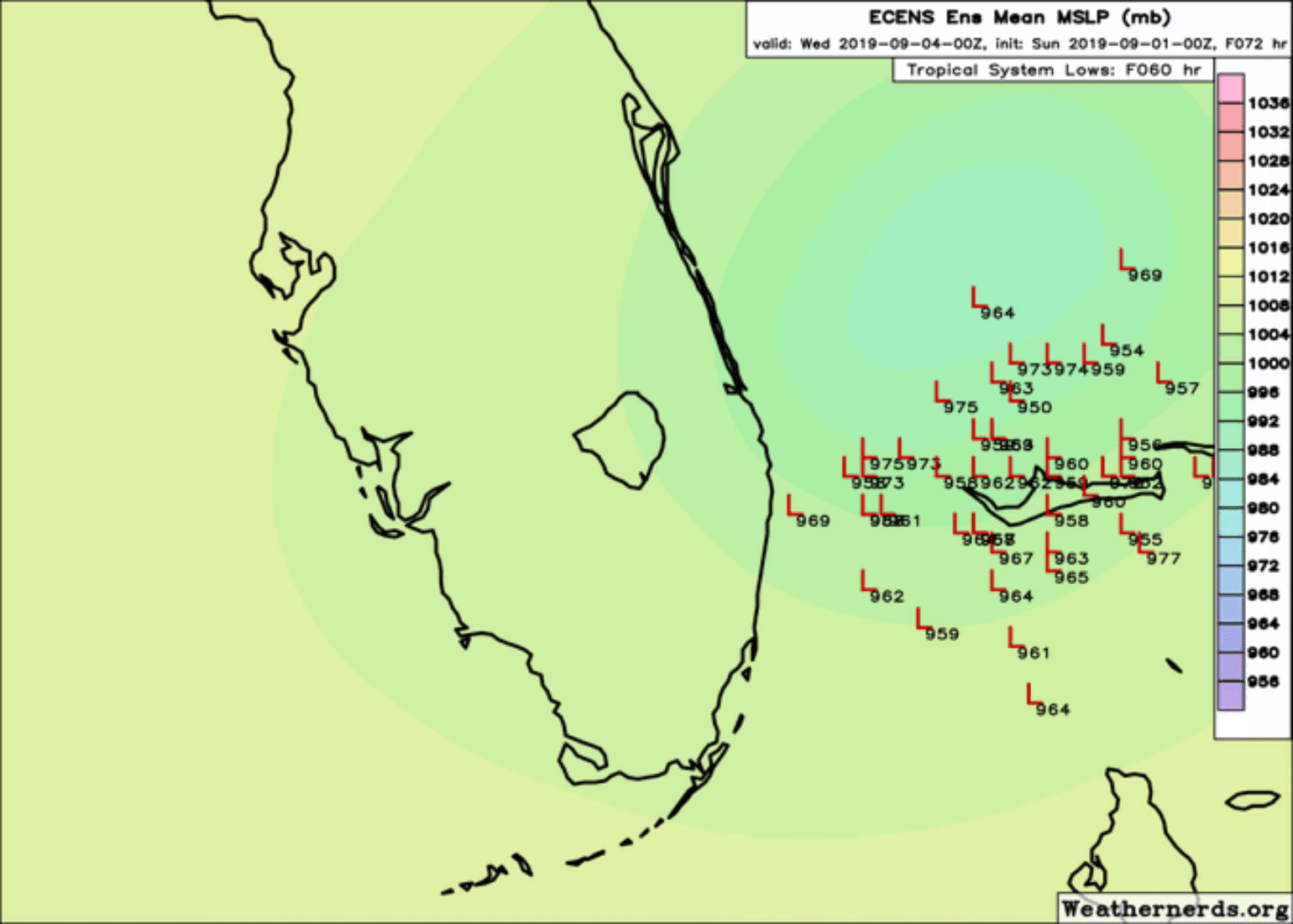
Dorian’s motion, for the most part, has closely followed the last several NHC forecast tracks, though it is still consistently traveling incrementally faster than expected. While that sounds inconsequential, slight differences in forward motion over the next two days are hugely critical to what the effect will be to Florida if the storm tracks farther west than expected, versus if the storm tracks more slowly and stays east, which would result in only modest impacts to the insurance industry. The NHC forecast drops Dorian’s forward speed to about 3-4 mph between late tonight through Tuesday morning so, again, this will be critical to watch. The NHC forecasts have been closely aligned with the American Global Forecast System (GFS) and European Center for Medium Range Weather Forecasts (ECMWF) ensemble guidance, which has shown run-to-run stability, as opposed to some of the deterministic models which seem to have different solutions each forecast cycle. The impact has become a game of miles, since truly dangerous conditions will extend 50 - 75 miles from the center if the storm stays at its current size. At this time, it does not look like the storm will become much larger in size, like Sandy or Floyd, but this could change with a few eyewall replacement cycles, which largely have not occurred with Dorian thus far.
The short term forecast for Hurricane #Dorian is definitely concerning.
— Ryan Maue (@RyanMaue) September 1, 2019
The center will likely remain offshore but the margin for error is only 10s of miles between major hurricane conditions vs. not.
(ECMWF 06z model -- @weathermodels_ ) pic.twitter.com/3Hu3mzhA0O
Longer Range Forecast
There is very little change in the long-range forecast due to the uncertainty in the prior 60 hours. Exactly how close the eye makes it to the coast of Georgia, South Carolina or NorthCarolina is still something we don’t know, and likely won’t until Monday afternoon or Tuesday. By Wednesday, the storm will be approaching Jacksonville,Florida’s latitude and will begin turning to the northeast in response to an advancing mid-latitude trough. This will bring the storm either over or very close toGeorgia, South Carolina, and North Carolina. On Friday morning, the storm will be departing North Carolina and heading to the northeast while transitioning into a powerful extratropical cyclone in the North Atlantic. The storm may pass close enough to Cape Cod to bring rain and wind to parts of New England, but it’s far too early to tell what the extent of those impacts might be.
Impacts
The Florida east coast from roughlyWest Palm Beach to Jacksonville remains in the NHC’s three-day cone of uncertainty for potential center locations. This cone is based on typical NHC track forecast errors over the past five years and is intentionally designed so that about one-third of hurricane positions end up outside the cone. Dorian’s track errors thus far have been anything but typical, so the storm is being watched very closely. Based on the models, at this time it seems there are three major scenarios: (1) a 15% chance of actual landfall, probably somewhere north of Vero Beach followed by a turn north up the peninsula; (2) a 30% chance of Dorian passing within 50 miles of the Florida coast and bringing significant coastal wind and rain; and (3) a 55%chance of a turn far enough offshore that impact will be relatively minimal. Of course, these odds are fluid and will change tomorrow once we see what the forward motion of the storm is doing over the Bahamas.
Wind
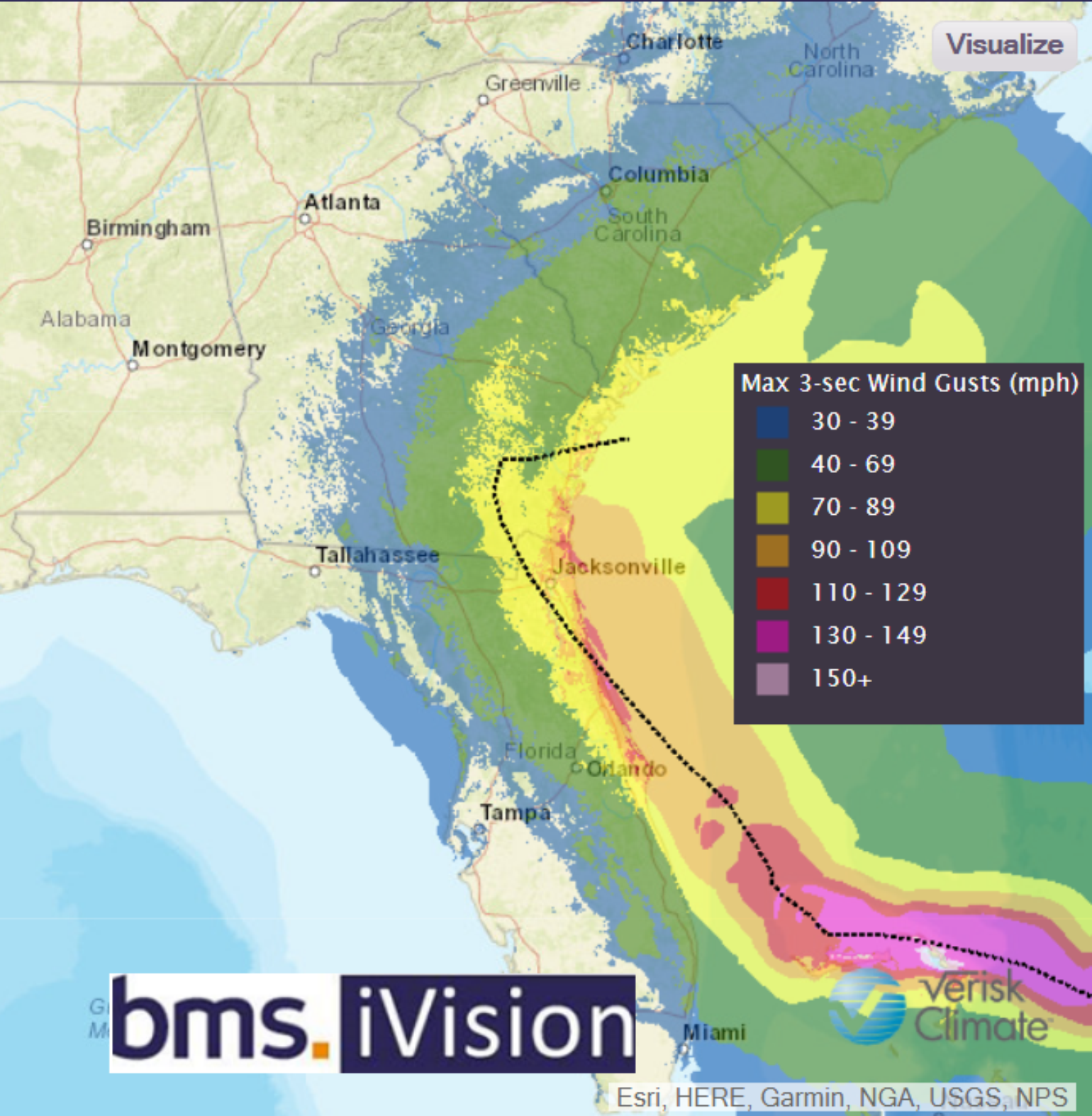
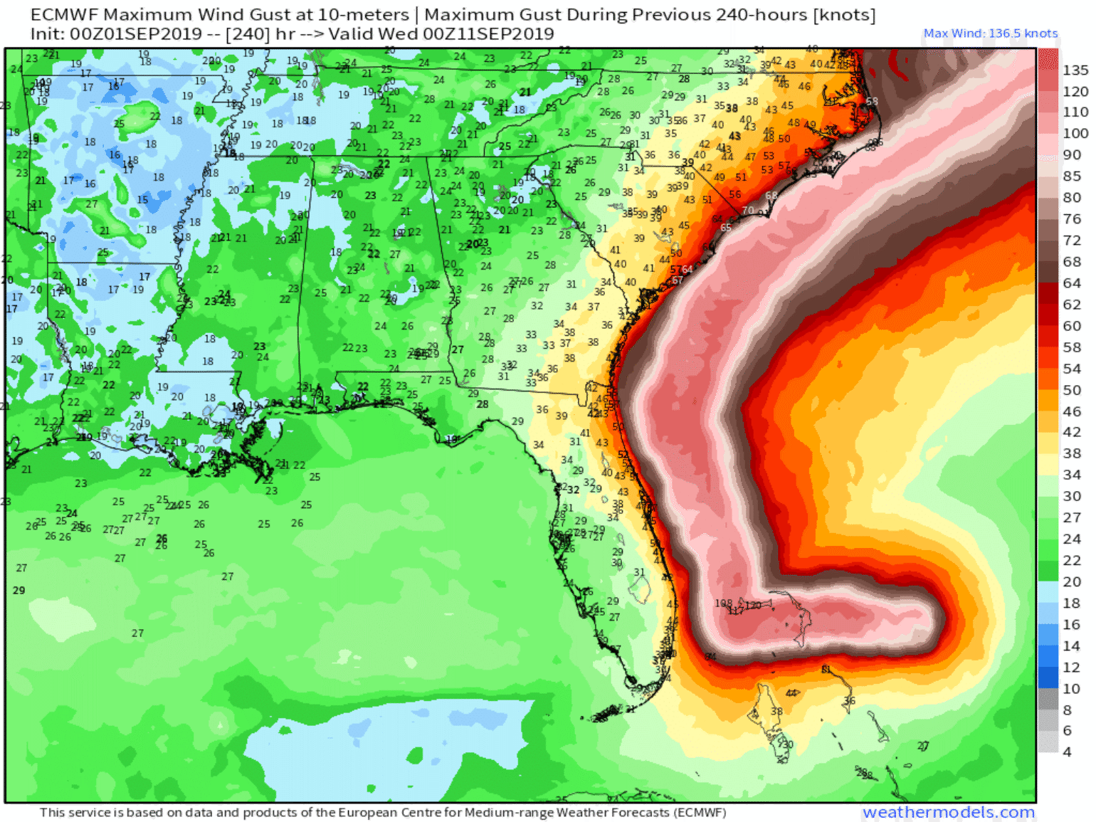
As stated several times, the wind impacts along the coastline will all depend on the track. Maybe it will be similar to Hurricane Matthew in 2016, as pointed out yesterday, which caused about $1B in insured loss to Florida. However, if the storm grows in size or tracks closer to the coastline and results in much stronger winds, the insured losses could easily grow as they did with Hurricane Floyd in 1999. It is far too early to understand what the impact might be to Georgia, South Carolina or North Carolina, but the same principles apply. If the storm tracks closer to the coastline or makes landfall, surely the insured loss will be greater than if the storm tracks farther from the coast.
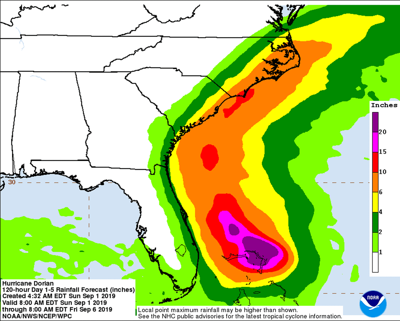
Flood
Similar to wind, the impact of rain will depend on the track of the hurricane. Currently, the freshwater flooding is not a concern if the storm does not make landfall, and the rain that does fall should be manageable if the storm stays 60+ miles off the Florida coastline. The biggest flooding concern in the current forecast are the significant wave heights that are expected over the next several days with the storm producing intense swells in excess of 30 feet as it moves north and then northeast. These waves will likely produce dangerous surf along ocean-facing beaches, beach erosion, and potential coastal flooding given the extremely high tides this weekend.
Final Thoughts
In meteorology forecasting class, I wastaught to not verify a forecast with a forecast. There are encouraging signsthat the overall insured impacts from Dorian will be minimal, but there isstill a lot of uncertainty to the potential impact to Florida or to pointsnorth in the Carolinas.