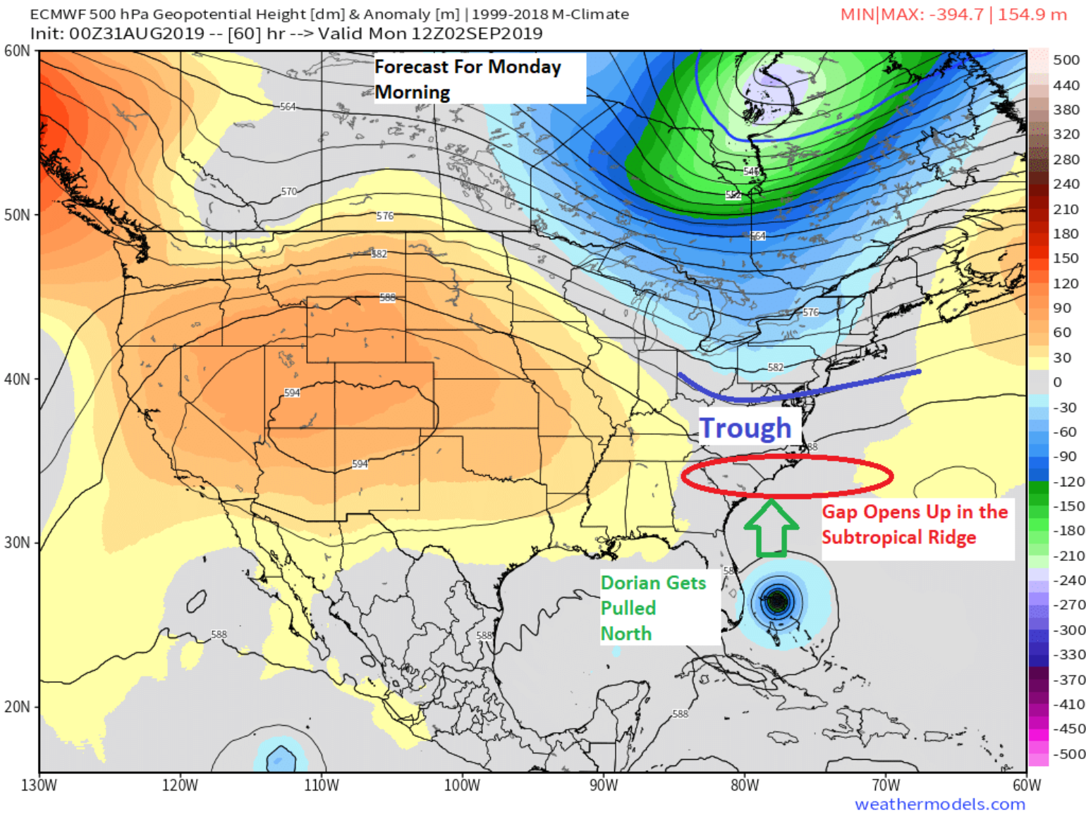
As expected, Dorian is currently a healthy Category 4 hurricane about 445 miles east of West Palm Beach, Florida. I would expect Dorain to track toward the northern Bahamas today and it would not surprise me if for a brief period it reaches the status of a Category 5 hurricane. However, starting tonight, Dorian should start to slow its forward motion which is currently at 12 mph. There is high confidence that Dorian should be near the northern parts of Abaco Island in the Bahamas by Sunday afternoon. This, however, is where the forecast uncertainty starts to build. Because we don’t know how much Dorian will slow down, we don’t know exactly where it will be on Monday. This is critical because on Monday night, the subtropical ridge that has been steering the storm westward is forecasted to weaken due to the arrival of some upper-level energy from the polar jet stream in the mid-latitudes which might allow Dorian to begin a northward turn into that gap of the upper-level ridge that has been keeping Dorian from moving northward.
Since last Wednesday, I have been talking about the overall forecast uncertainty with Dorian and early on mentioned the angle at which Dorian impacts the Florida coastline will make a large difference in how it affects the state, including the effects of storm surge and coastline winds. The angle of high winds can create different outcomes, which is why the angle of impact is important. In the last few track forecasts, the impacts of some of the tracks are less perpendicular to the coastline as the storm is expected to turn northward before a potential landfall which is quite different than the forecast just 36 hours ago.
Since Wednesday, I also highlighted many things that can help the insurance industry limit the effects from the uncertainty in the forecast. One of the things I failed to mention was in Meteorology forecasting classes one of the lessons they teach is, “the trend is your friend.” Over the last 36 hours or so the long range forecast guidance has been trending to a slower moving storm which is resulting in forecast guidance that Dorian might not make a Florida landfall and may actually turn to the north and track along the Florida coastline due to the weakness in the upper-level ridge as described above. Yesterday I mentioned that the slow-movement of named storms often precedes erratic behavior or sharp turns, so what this trend suggests today is that Dorian may stay offshore, similar to Hurricane Matthew in 2016. In this case, “the trend is your friend” as this overall scenario would drastically limit insured losses.
Analogs
There is no shortage of hurricanes that have bypassed Florida. These types of bypassing storms have had varying impacts. One might remember that Hurricane Floyd in 1999 caused substantial loss along the east coast of the U.S. and in today’s dollars resulted in close to $15–$20 billion in insured loss. In contrast, Hurricane Matthew in 2016 was another very powerful category 3-4 hurricane as it tracked up the coastline but only caused about $1 billion in insured loss to Florida. Both of these storms were clearly different with different impacts. Maybe the coastline has become more resilient since 1999 which might explain part of the loss difference between events. Both Floyd and Matthew were also impactful storms to Georgia, South Carolina and North Carolina, and this potential seems to be the overall risk focus for Dorian in the longer range as the models are locking onto different scenarios than a Florida landfall. But the short term risk is not over for Florida as there is still a probability of coastal sections seeing hurricane-force winds.
Wind Impacts
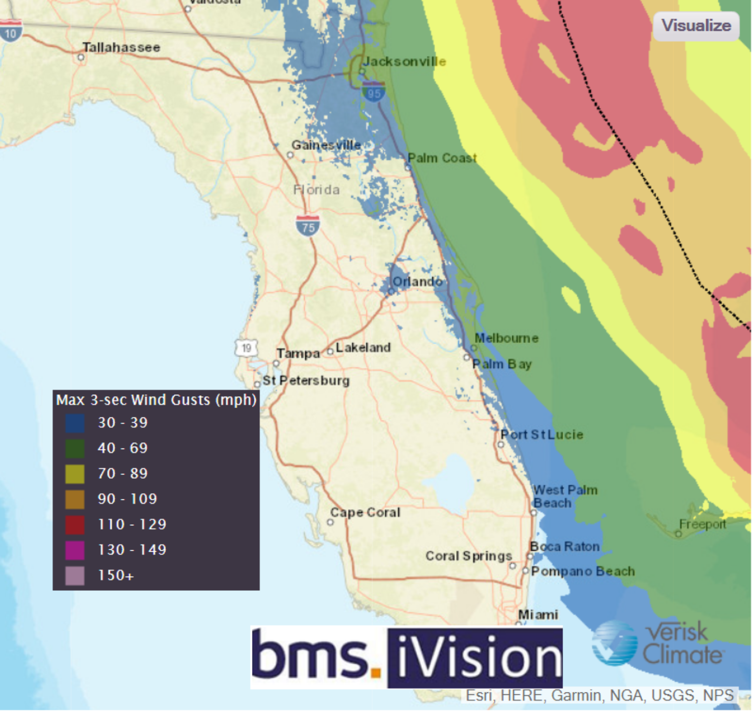
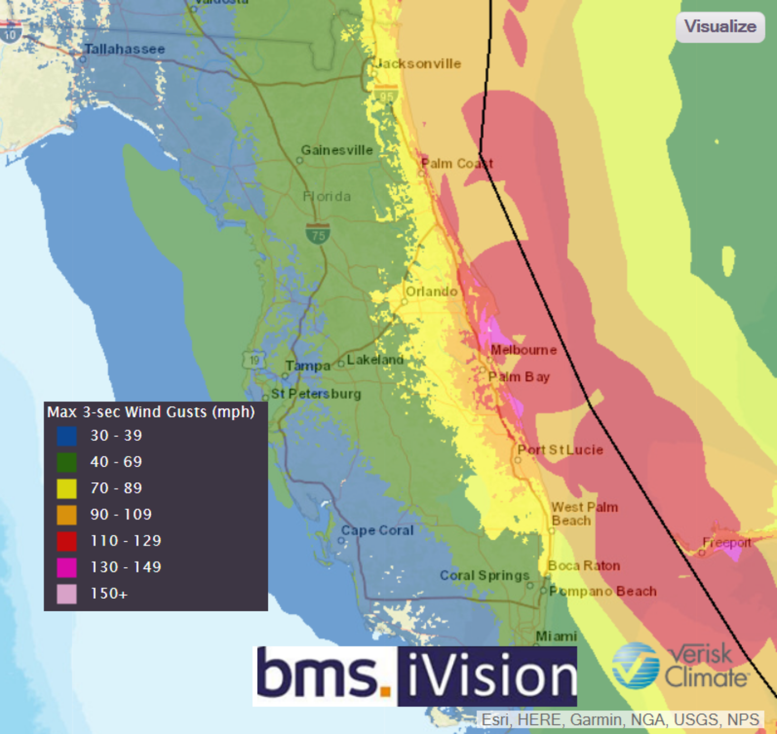
As discussed above, many forecast models have backed away from a Florida landfall. This change is the current outlook that is forecasted by Verisk Weather Solutions, which shows minimal impacts to the Florida coastline. Using BMS iVision users can also select historical storm tracks to understand expected loss. Below I show the BMS iVision Verisk Weather Solutions verification for Hurricane Matthew in 2016 which may also represent an idea of what type of winds to expect along the coastline as another potential forecast scenario for Dorian. It should be noted, however, that depending on the overall storm size, slight shifts in the forecasted track could result in a big difference in what types of wind speeds are experienced along the coastline of Florida which might be the difference in Dorian following Floyd in 1999 or Matthew in 2016.
FloodImpacts
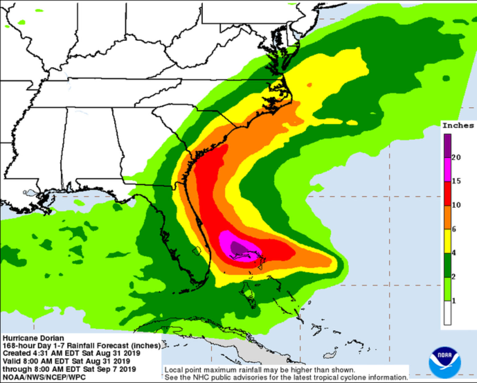
The good news is with Dorian shifting its forecasted track to the east of Florida the trend has moved the heaviest rain eastward as well. This means that freshwater flooding may not be as bad, but the coastal section could still see rain and the compounding impacts of storm surge with waves and coastal erosion. The current forecast expects significant wave heights for the next several days with the storm producing intense swells in excess of 30 feet as it moves north and then northeast. These waves will likely produce dangerous surf along ocean-facing beaches, beach erosion, and potential coastal flooding given the extremely high tides this weekend.
Long Range Ideas Impacts for Dorian
Exactly how close the center of Dorian makes it to the Florida coast is still something we don’t know, and likely won’t until Monday. By Wednesday, the storm is expected to still be offshore near Jacksonville, Florida. The current expectation is that it will begin turning to the northeast in response to an approaching mid-latitude trough. This will bring the storm either over, or very close to, Georgia, South Carolina and North Carolina. Again, the exact track is still uncertain but the general idea is becoming much clearer. On Thursday, the storm will probably be departing North Carolina and heading off to the northeast as it transitions into a powerful extratropical cyclone. The storm may pass close enough to Cape Cod to bring rain and wind to parts of New England, but it’s far too early to tell what the extent of those impacts might be.