As mentioned in the last BMS Tropical Update, a storm is brewing in the Gulf of Mexico. The National Hurricane Center has now named this system Tropical Storm Barry and expects it to potentially become a hurricane by Saturday and make landfall shortly thereafter, with possible impacts along the coasts of Texas and Louisiana, particularly in the city of New Orleans. As many already know, New Orleans sits below sea level and has had its share of flooding problems in the past. Since water is the new wind risk for the insurance industry, this BMS Insight will focus on this threat in a bit more detail, as any wind damage at this time is uncertain given the high forecast uncertainty around the overall intensity and track of the storm.
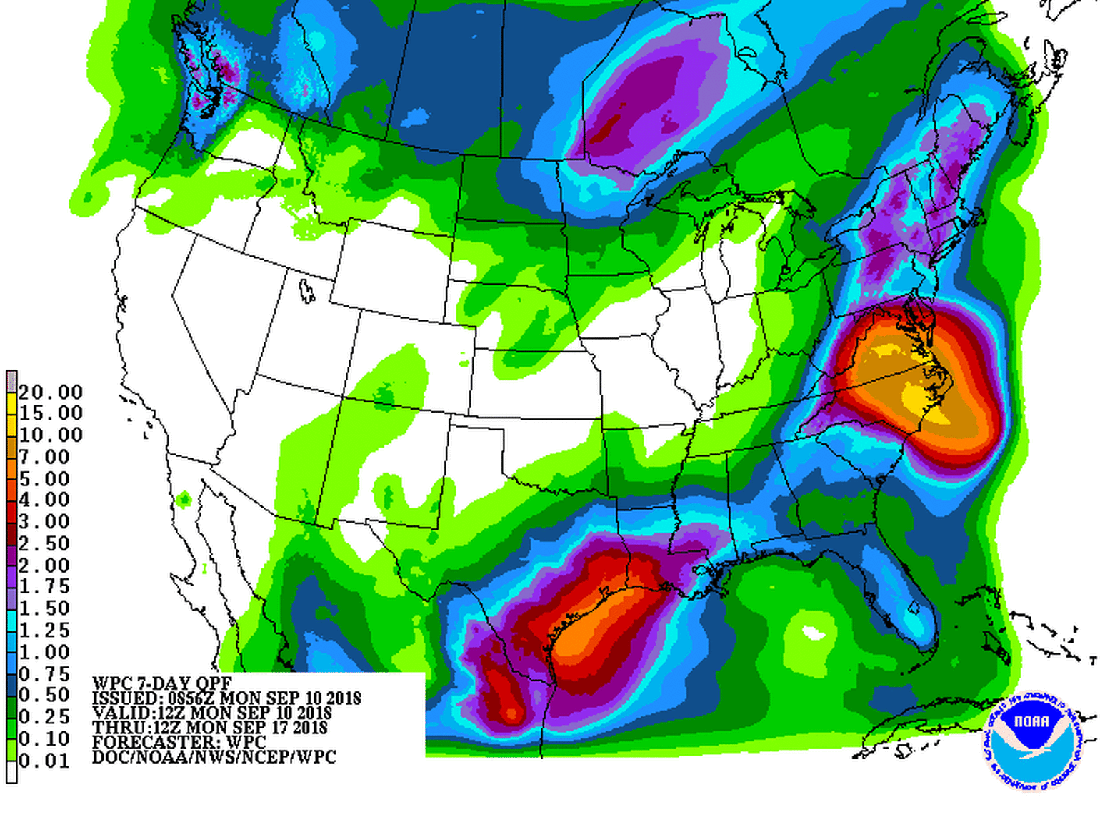
The forecast models are suggesting as much as 18 inches of rain for the region, which isn’t good, considering that the area is already inundated with rain. New Orleans has already flooded this week from rain, with many streets covered with a dangerous amount of water. The Mississippi River is expected to rise to 19 or 20 feet by the weekend, which is near the height of the city’s levees.
By Saturday, it may have winds of 85 mph, making it a Category 1 hurricane on the Saffir-Simpson wind scale. It should be noted, however, that there is a lot of uncertainty around the forecasted intensity of the storm. This intensity will depend on how much wind shear the storm encounters and how much time it spends over the warm waters of the Gulf of Mexico. Currently, the worst-case scenario appears to be a Category 1 hurricane. However, forecasts can change fast, as we experienced with Michael last year. Most of the model guidance is suggesting a lopsided tropical storm with a landfall somewhere along the Louisiana coastline.
Wind speed is just one of the insured loss concerns from the storm. Historically, flooding has not been a big concern for the insurance industry, but the take-up rates of flood insurance are higher in Louisiana, including New Orleans. The reinsurance markets are taking on some of the risk from the National Flood InsuranceProgram, so this flood risk needs to be watched. Also, coastal flooding tends to be the deadliest aspect of a hurricane.
The main concern here is that the storm surge combined with heavy rainfall could reach 3 to 5 feet, which would flood many of the low-lying areas of Louisiana. This storm is expected to generate a lot of rain, with some areas potentially seeing more than a foot, which can contribute to inland flooding along the banks of rivers.
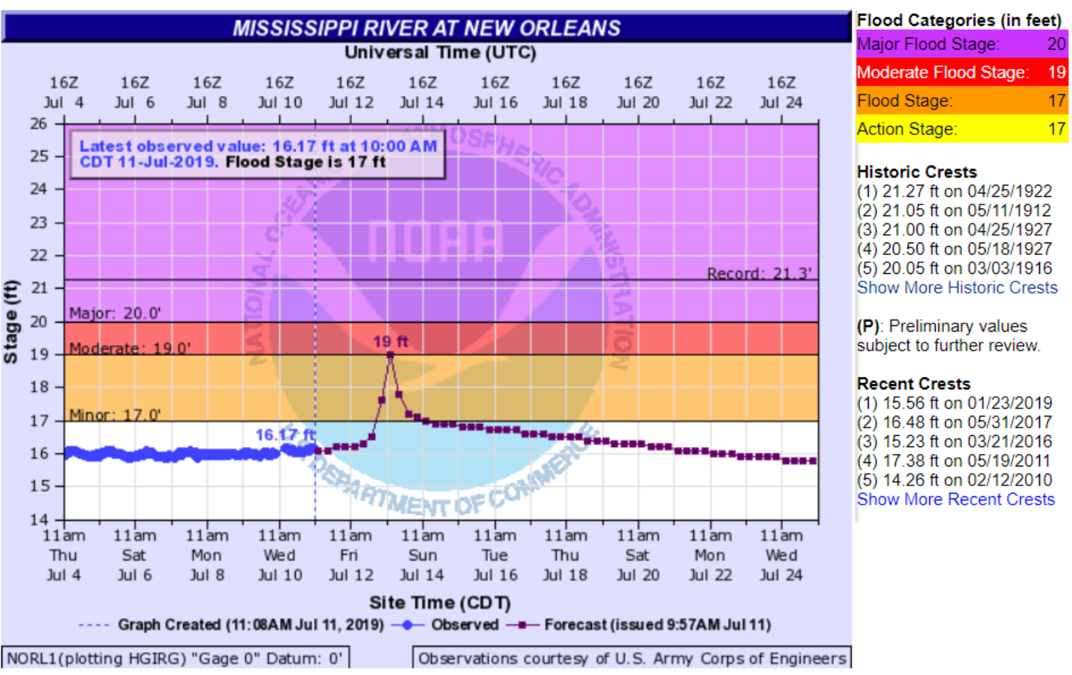
The biggest threat from the storm may be in New Orleans, where the Mississippi River is already at 16 feet due to the very wet spring and summer upstream. Some states along the river have seen their wettest spring in recorded history. All of this water has worked its way down the Mississippi River, which has been high for well over a month now. The National Weather Service is now predicting the river to crest at 19 feet on Saturday. That is one foot below the top of the river levees. This could change given the track of the forecast. This morning the forecasted river height was 20 feet, so the forecast is changing for the better since the newest forecast is now one foot below the top of some of the levees.
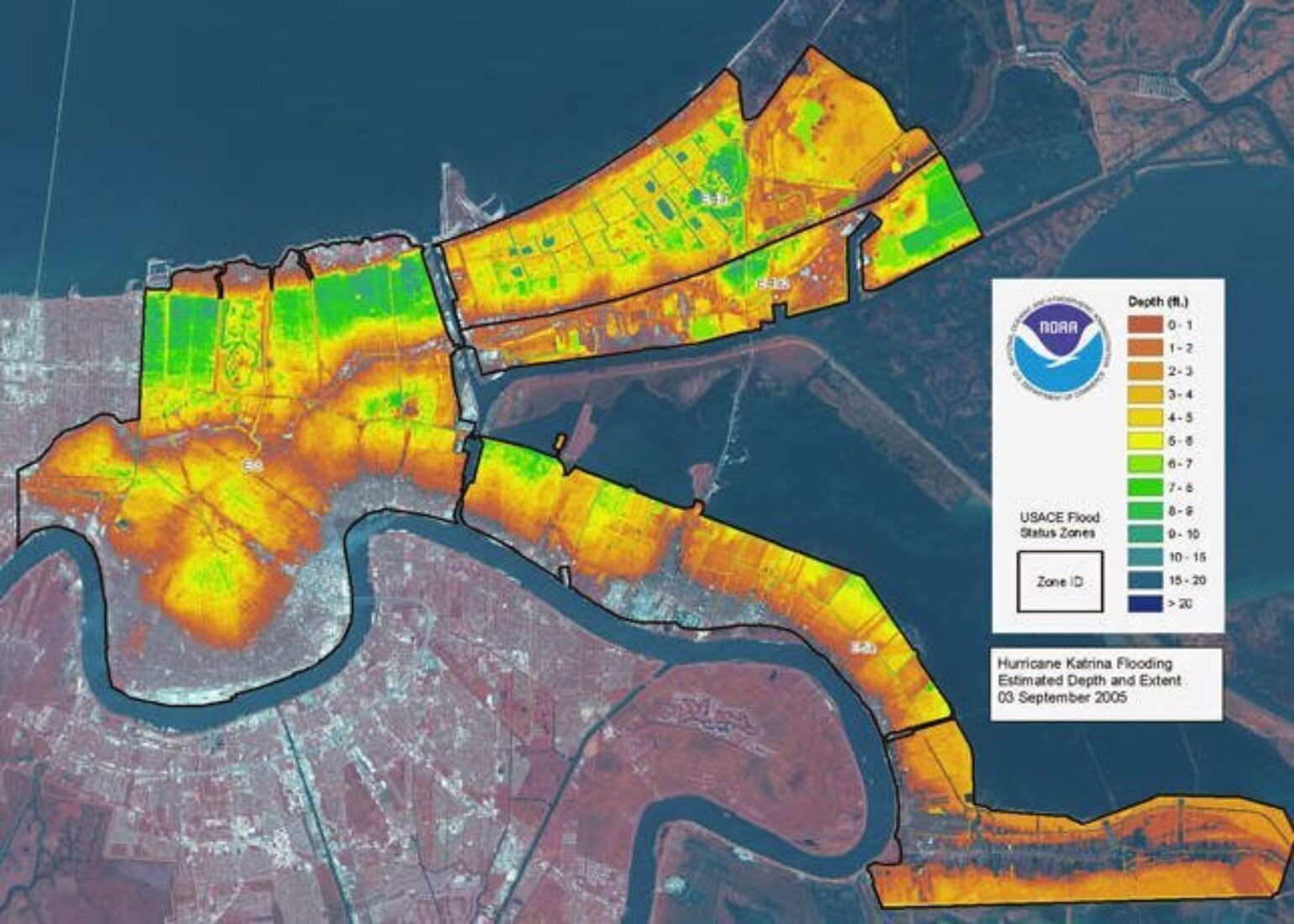
So, why is this a concern? During both Hurricane Katrina in 2005 and Hurricane Isaac in 2012, storm surge pushed well upriver. In those cases, however, the river was only at a level of 3 feet or less. During Katrina, a Category 3 hurricane with top winds of 125 mph, the river swelled to at least 15.25 feet at the Carrollton Gage in New Orleans. The gage stopped operating when the water reached that level. Several barges were deposited on top of the levees in Plaquemines Parish during the storm by surge water. During Isaac, a Category 1 hurricane with top winds of 80 mph, the river rose to 9.5 feet at the Carrollton Gage. While the current river level in New Orleans is 16 feet, levees and floodwalls protect the city up to water heights of about 20 feet.
How high is a 20-foot-high river stage for New Orleans? It is higher than 99.9% of the city's land surface, higher than every human being except those in multi-story buildings and about 30 feet higher than the lowest neighborhoods.

In summary, the precursor for a bad flooding event is set for New Orleans and remains for much of the hurricane season. Many areas of Louisiana are flat, and flooding is a big concern with this upcoming storm. There is uncertainty at this time around the potential strength and track of the storm, which also increases the level of uncertainty around the storm surge that may be expected. However, the rainfall forecasts have been fairly consistent over the last several days, with most of the heaviest rain expected to fall along with the storm’s forecasted path.